Topographic Study guides, Class notes & Summaries
Looking for the best study guides, study notes and summaries about Topographic? On this page you'll find 855 study documents about Topographic.
Popular textbooks 'Topographic'
All 855 results
Sort by
 Popular
-
EPS SCI 9 (UCLA) Final Exam Prep Questions and Answers Best rated A+ Guaranteed Success Latest Update
- Exam (elaborations) • 14 pages • 2024
- $7.99
- 1x sold
- + learn more
What is the rotation period of Mercury (sidereal day)? - 59 Earth days How long is one solar day on Mercury? - 176 Earth days What is orbital period of Mercury? - 88 Earth days What is partially molten and takes up 75% of the diameter of its planet? - Mercury's core What planet is smaller than many moons in the SS? -Mercury What is the range of topography on Mercury like? - very small variety What planet has the most extreme temperatures in the SS? - Mercury (800°F to -350°F) What plane...
 Popular
-
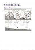
IEB/NSC - Geo - Geomorphology
- Summary • 16 pages • 2023 Popular
- $5.52
- 1x sold
- + learn more
This summary cover the following topics for Grade 12 Geomorphology: Drainage Systems in South Africa • important concepts: drainage basin, catchment area, river system, watershed, tributary, river mouth, source, confluence, water table, surface run-off and groundwater • types of rivers: permanent, periodic, episodic and exotic • drainage patterns: dendritic, trellis, rectangular, radial, centripetal, deranged and parallel • drainage density • stream order • use of topographi...
-
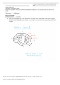
Graded Assignment | Lab Report | Topographic Maps
- Exam (elaborations) • 3 pages • 2023
- $5.49
- 2x sold
- + learn more
Graded Assignment Lap Report: Topographic Maps Answer the questions. When you are finished, submit this assignment to your teacher by the due date for full credit. Total score: ____ of 35 points Map and Profile (Score for Question 1: ___ of 14 points) 1. Draw your topographic map in the space below. Include the name of the island, scale, legend, compass direction, vertical units and contour interval on your map. If you need more room, you can use a full sheet of pap
-
INTERMEDIATE WILDLAND FIRE BEHAVIOR:S-290 EXAM | QUESTIONS & ANSWERS (VERIFIED) | LATEST UPDATE | GRADED A+
- Exam (elaborations) • 19 pages • 2024
- $11.49
- 1x sold
- + learn more
Seven Wild-land Fire Environment Factors. ANSWER: -Terrain - Fuel Characteristic -Fire Triangle -Wind - Fuel Moisture -Stability - Fuel Temperature Weather factors relating to wild and fire behavior. ANSWER: temperature, relative humidity, atmospheric stability, windspeed and direction,precipitation Topographic factors important to woodland fire behavior. ANSWER: Elevation, position on slop, aspect, shape of the country, steepness of slope
-
PA Pesticide Applicator Exam Core Info with correct answers 2023
- Exam (elaborations) • 6 pages • 2023
- $26.49
- 9x sold
- + learn more
PA Pesticide Applicator Exam Core Info with correct answers 2023Bioaccumulation The accumulation of a substance, such as a toxic chemical, in various tissues of a living organism. Biomagnification Accumulation of pollutants at successive levels of the food chain abiotic factors natural control measures within the environment. EX: climactic factors, air/water pollution, topographic features. Biological Control The use of natural enemies to control pests. EX: Predators, ...


-
Tactical Tools (Corporal's Course) questions and answers 2023
- Exam (elaborations) • 39 pages • 2023
- $30.49
- 3x sold
- + learn more
A map is defined as a graphic representation of a portion of the Earth's surface drawn to scale, as seen from above. It uses colors, symbols, and labels to represent features found on the ground. -The ideal representation would be realized if every feature of the area being mapped could be shown in true shape. -The purpose of a map is to provide information on the existence, location, and distance between ground features, such as populated places and routes of travel and communication. I...
-
Topographic Maps Exam Questions with Correct Answers
- Exam (elaborations) • 3 pages • 2023
- $12.99
- + learn more
Topographic Maps Exam Questions with Correct Answers Topographic Map - Answer-shows the surface features, or topography of Earth or a certain area. What does a topographic map show? - Answer-it shows natural features such as rivers and lakes. They also show some features made by people such as brodges. They also show elevation. Elevation - Answer-The height of an object above the surface of the sea. What is the elevation at sea level? - Answer-The elevation at sea level is zero mete...
-
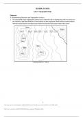
Sketching Assignment - Topographic Maps - Already Graded A+
- Exam (elaborations) • 6 pages • 2023
- $9.99
- + learn more
ESC1000L, GLY1010L Lab 2: Topographic Maps Elaborate A: Understanding Elevations and Topographic Contours 1. The map below shows topographic contours at an interval of 20 m. Starting from the 0 m contour at the shoreline, label the elevations of the contours on the map below. Note that the closed contours with the inward hatches are depressions where the elevation decreases towards the center.

-
Test Bank for Cognitive Neuroscience, The Biology of the Mind 5th Edition by Gazzaniga
- Exam (elaborations) • 182 pages • 2022
- $25.00
- 4x sold
- + learn more
1. What term was coined by Thomas Willis as a consequence of the case of Anne Green? a. psychopathology b. cognition c. neurology d. psychosis ANS: C DIF: Easy REF: 1.1 A Historical Perspective OBJ: 1.1 MSC: Remembering 2. Aside from saving Anne Green’s life, Thomas Willis and Christopher Wren also a. created very accurate drawings of the brain. b. came up with the names of a number of brain structures. c. took the first steps that led to cognitive neuroscience. d. All of the answer options ar...
-
Topographic Map Exam Questions with Correct Answers
- Exam (elaborations) • 2 pages • 2023
- $12.49
- + learn more
Topographic Map Exam Questions with Correct Answers On a topographic map, the difference in elevation between two side-by-side contour lines is called the ___ A. contour interval B. index contour C. depression contour D. hachure - Answer-A. contour interval A point of known elevation on a topographic map is called a/an A. hachure B. contour interval C. topographic profile D. elevation - Answer-C. topographic profile The vertical distance between a given point and the datum plane ...
-
Topographic Maps Test Questions with Correct Answers
- Exam (elaborations) • 2 pages • 2023
- $11.49
- + learn more
Topographic Maps Test Questions with Correct Answers Mapmakers use contour lines to represent what three things on topographic maps? - Answer-elevation, relief, and slope contour line - Answer-A contour line on a topographic map connects points of equal elevation. contour interval - Answer-The change in elevation from contour line to contour line is called the contour interval. index contours - Answer-Every fifth line, known as the index contour, is darker and heavier than the other...
