Topographic Study guides, Class notes & Summaries
Looking for the best study guides, study notes and summaries about Topographic? On this page you'll find 907 study documents about Topographic.
Page 3 out of 907 results
Sort by
-
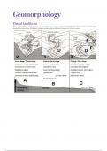
IEB/NSC - Geo - Geomorphology
- Summary • 16 pages • 2023
- $5.67
- 1x sold
- + learn more
This summary cover the following topics for Grade 12 Geomorphology: Drainage Systems in South Africa • important concepts: drainage basin, catchment area, river system, watershed, tributary, river mouth, source, confluence, water table, surface run-off and groundwater • types of rivers: permanent, periodic, episodic and exotic • drainage patterns: dendritic, trellis, rectangular, radial, centripetal, deranged and parallel • drainage density • stream order • use of topographi...

-
Geology Lab Exam II Questions and Answers 2024 with Complete Solution.
- Exam (elaborations) • 15 pages • 2024
- $12.99
- + learn more
Geology Lab Exam II Questions and Answers 2024 with Complete Solution. A topographic map has a ratio scale of 1:250,000. One centimeter on the map equals _____ kilometers in the real world. 2.5 Assuming a contour interval of 50 feet, what is the elevation of the centermost contour line in this figure? Please observe that the first contour line has an elevation of 100 feet above sea level. 300 feet Use the Public Land Survey System to locate the X out to three quarters. Assume that it is...
-
UCLA EPSS 61 Final Questions And Answers Rated A+ New Update Assured Satisfaction
- Exam (elaborations) • 11 pages • 2024
- $7.99
- + learn more
Define Geologic Map - A record of the locations, orientations, and relationships between bodies of rock and geologic structures. List the three things that all maps must convey - 1: The Location of the map 2: The Orientation of the map 3: The Scale of the map Explain how latitude and longitude define a point on Earth's surface - Any point on Earth can be defined by the intersection of its lines of latitude and longitude. Latitude is the flat horizontal lines (flatitude) and longitude are...

-
Topographic Map Exam Questions with Correct Answers
- Exam (elaborations) • 2 pages • 2024
- $8.59
- + learn more
Topographic Map Exam Questions with Correct Answers On a topographic map, the difference in elevation between two side-by-side contour lines is called the ___ A. contour interval B. index contour C. depression contour D. hachure - Answer-A. contour interval A point of known elevation on a topographic map is called a/an A. hachure B. contour interval C. topographic profile D. elevation - Answer-C. topographic profile The vertical distance between a given point and the datum plane ...

-
Topographic Maps Exam Questions with Correct Answers
- Exam (elaborations) • 3 pages • 2024
- $7.99
- + learn more
Topographic Maps Exam Questions with Correct Answers Topographic Map - Answer-shows the surface features, or topography of Earth or a certain area. What does a topographic map show? - Answer-it shows natural features such as rivers and lakes. They also show some features made by people such as brodges. They also show elevation. Elevation - Answer-The height of an object above the surface of the sea. What is the elevation at sea level? - Answer-The elevation at sea level is zero meters...

Get paid weekly? You can!

-
S-290 Questions and Answers Already Passed
- Exam (elaborations) • 23 pages • 2024
- $9.99
- + learn more
S-290 Questions and Answers Already Passed Name the 5 weather factors that effect fire behavior. (WARPT) Windspeed and direction Atmospheric stability Relative Humidity Precipitation Temperature Name the 5 topographic factors that affect fire behavior Elevation Position on slope Aspect Shape of the country Steepness of slope Name the 7 fuel factors that effect fire behavior Fuel loading Size and shape Compactness Horizontal continuity Vertical continuity Chemical content Fuel moisture and Fue...
-
Geology Lab Exam II Questions and Answers 2024 with Complete Solution.
- Exam (elaborations) • 15 pages • 2024
- $14.99
- + learn more
Geology Lab Exam II Questions and Answers 2024 with Complete Solution. A topographic map has a ratio scale of 1:250,000. One centimeter on the map equals _____ kilometers in the real world. 2.5 Assuming a contour interval of 50 feet, what is the elevation of the centermost contour line in this figure? Please observe that the first contour line has an elevation of 100 feet above sea level. 300 feet Use the Public Land Survey System to locate the X out to three quarters. Assume that it is...
-
NCCER Electrical 1 Module 10 Questions and Answers Graded A
- Exam (elaborations) • 6 pages • 2023
- $9.99
- 1x sold
- + learn more
NCCER Electrical 1 Module 10 Questions and Answers Graded A Blue Prints An exact copy of reproduction of an original drawing Floor plan As viewed from above Site plan Location of building on the property Surveys show All property lines, existing public utilities and their location on or near the property Elevation drawings show The exterior face of the building Floor plans are in 2 dimension, length and width Topographic survey shows Property lines, contour lines, notes and symbols Sectio...
-
Grade 12 Geography Summaries Skills & Techniques plus Topic 1 & 2 (Term 1) - Via Afrika
- Summary • 72 pages • 2024
- $8.59
- + learn more
Grade 12 Geography Summaries Topic 1 & 2 (Term 1). This summaries are composed using and combining the Via Afrika textbooks' work with examples and supplementary notes. This product also contains the summaries for Geographic skills and Techniques (Terms 1 - 4). Contents: Geographical Skills and Techniques: Mapwork techniques. Topographic maps. Aerial photographs and orthophoto maps. Geographic Information Systems (GIS). Using atlases. Topic 1: Climate and Weather Mid-latit...
-
LSIT EXAM 2024 WITH 100% CORRECT ANSWERS
- Exam (elaborations) • 20 pages • 2024
- $16.49
- + learn more
LSIT EXAM 2024 WITH 100% CORRECT ANSWERS (i) mathematics, (ii) legal principles, (iii) types of surveys and (iv) survey computations - correct answer Know these forsure Survey Process and Methods - correct answer -Instrumentation (e.g., GNSS/GPS, levels, total stations, robotic total stations, scanners, UAS) -GNSS/GPS surveys (e.g., static, kinematic, OPUS, real-time networks) -Control surveys (e.g., horizontal, vertical, network design, accuracy standards) -Cadastral (e.g., Pub...
