Hazardous Environments Revision
9.1: Hazards resulting from tectonic processes
Hazard: A dangerous phenomenon, substance, human activity or condition that may cause loss of life, injury or other health impacts, property
damage, loss of livelihoods and services, social and economic disruption, or environmental damage.
Earthquake: a sudden and violent series of vibrations/shaking or seismic (shock) waves which originate
from the focus.
Focus: the point within the crust where the earthquake happens and where the plates release their
tension or compression suddenly. Where the earthquake originates.
Epicentre: the point on the ground immediately above the focus.
Earthquakes are strongest at the epicentre but the most damage is caused where there are more buildings. If the epicentre is in the middle
of no-where with barely any population, earthquakes are not as dangerous.
Great earthquakes magnitude 8 or greater occur once a year.
Plates move at a rate of 1.5-7.5 cm a year.
Global Distribution of Earthquakes and Volcanoes
90% of worlds tsunamis occur in Pacific Ocean. Associated with subduction zones.
Earthquakes → clearly defined, linear patterns which follow plate
boundaries.
Broad belts of earthquakes → associated with subduction zones.
Narrower belts of earthquakes → associated with constructive plate
margins.
Isolated occurrences of earthquakes are due to human activities or isolated
plumes of rising magma (hotspots).
Tectonic Plate: one of the structural components that make up the earth’s
lithosphere (crust)
Types of Crust
Continental Crust Oceanic Crust
Thickness 35-70km; thicker 6-10km – thinner
Age Old; 1500 million years Young; <200 million years
Density Less dense; 2.5 (buoyant) Denser; 3
Colour Light Dark
Nature Granitic rock → silica & oxygen, aluminium. Basaltic rock – silica & magnesium.
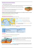
Plate Boundaries
Plate Boundaries – areas where 2 or more plates (pieces of crust) meet each other.
1. Divergent/Constructive eg: North American & Eurasian plates
Plates pull apart/move away from each other.
Sea-Floor Spreading: plates move apart → creates cracks & fissures → allows magma from
mantle to escape from pressurised interior of earth. Magma fills gap → erupts to surface →
cools & solidifies (new land).
Basaltic lava: runny, travels long distances, gently sloping land.
Oceanic Ridge: Elevated above ocean floor as they consist of hotter, less dense, younger
crust.
Ridge pull/push: process which aids the movement of tectonic plates because the ridge is at
a higher elation, gravity causes the ridge to push into the lithosphere causing the plates to move. New crust pushes older crust out of its way
because its less dense (as its hotter therefore rises up → upwelling of magma).
,Radioactive Decay heats magma, drives convection currents, makes it rise towards crust, cools down, becomes dense, sinks. Convection
Currents in opposite directions.
Sea-Floor Spreading: sideways/ lateral expansion/extension of some ocean floors as the oceanic plates move apart from a zone of separation
across a mid-ocean ridge. Caused by convection currents, creation of new sea. → Characterised by parallel magnetic stripping
(palaeomagnetism) & are part of constructive plate margins.
Mid-Ocean-Ridges: ridges of magma. Giant submarine mountain chains, very long (60,000 km), 1000-4000km wide. Where new lithosphere is
created. Rift along the spice/central ridge where magma escapes eg: Mid-Atlantic Ridge, East Pacific Rise. Eurasian plate moves away from the
North American plate.
Two continental diverging plates → rift valley.
2. Convergent/Destructive (3 types)
Plates are moving towards each other → causes earthquakes, volcanoes, deep ocean trenches, fold mountains, chains of island arcs.
a. Oceanic to Continental eg: Nazca plate subducting under S. American Plate
Oceanic plate is denser therefore subduction occurs with less dense continental plate
boundary → convection currents.
Slab-Pull: movement of plates into the asthenosphere.
Subduction Zone: occurs when an oceanic lithospheric plate collides with another plate.
Density of oceanic plate is similar to asthenosphere therefore can easily be subducted.
Subduction zones dip at angles of 30o-70o. The older the lithosphere, the steeper the
dip.
Benioff Zone: narrow zone of earthquakes dipping away from deep sea trench,
bends/dips at average angle 45o. → Earthquake foci exists.
Partial Melting in the Benioff Zone
Dehydration → oceanic crust is wet, subduction occurs, the plate dehydrates, steam is produced, creates magma, creates magma chamber as
rock is melted.
Oceanic Trench: deep v-shape valley, plates bend.
Fold mountains: marine sediments are squeezed between the 2 plates, scraped off the ocean floor them folded on the edge of the continental
plate.
The nature of volcanoes at such margins are mostly andesitic from the incorporation of continental rock with oceanic plate basalt
b. Continental to Continental (collision) eg: Indo-Australian Plate & Eurasian Plate
No subduction but one plate is thrust below the other → this pressure creates
compensatory thrust sheets, up thrust & folding.
Orographic Mountain Belts → fold mountains eg: Himalayas
Denser continental plate sinks underneath less dense plate (not into magma). Light, less
dense plate sediment may be bulked & folded up → fold mountains → forced upwards.
Indian subcontinent moved rapidly north in past 70 million years --> colliding with main body of Asia → huge ocean (Tethys) lost between
continental masses in the collision zones → crust has thickened → uplift of Himalayas.
c. Oceanic to Oceanic eg:
Oceanic Trench
Accretionary Prism → build-up of sediment scraped off oceanic plate as its being
subjected eg: Trinidad & Tobago, Barbados
Benioff Zone & Subduction Zone
Island Arcs: curvilinear group of volcanic islands. Formed when oceanic lithosphere is
subducted beneath oceanic lithosphere. Shrinking oceans (pacific). Located parallel (to
oceanic plate margin) to a trench on overriding plate eg: Grenada, St Kitts.
Eg of Island Arcs → Aleutian Islands, Alaska, USA.
,Hotspot Volcanoes: eg: Hawaiian Hotspot
Area in the mantle from which heat rises as a thermal plume from deep in the earth. Magma rises through the fault lines due to uplift of hot
rock, needs a fault line for magma to break through, erupted lava builds mountains, weight of volcano bends plate down, plate carries
volcanoes away from hotspot and new volcanoes form → chain forms.
**Intensive radioactivity in the Earth’s interior creates a huge column of upwelling lava, known as a “plume”. The plume of plastic rock from
the Asthenosphere pushes upwards; pressure drops and the plastic rocks become molten, melting and pushing through the crust above. This
lies at a fixed position under the Tectonic Plate. As the plate moves over this “hot spot”, the upwelling lava creates a steady succession of new
volcanoes that migrate along with the plate.
The major theory that Geologists believe is that a huge column of upwelling lava, known as a “plume,” lies at a fixed position under the Pacific
Plate. As the ocean floor moves over this “hot spot” at about five inches a year, the upwelling lava creates a steady succession of new
volcanoes that migrate along with the plate - a veritable conveyor belt of volcanic islands. Hawaii itself consists of five connected volcanic
mountains that were built by this lava plume rising from the mantle. Kilauea, the world’s largest active volcano, is still rumbling because the
island has yet to move completely off the hot spot**.
Hot spots are located mainly away from plate margins where magma plumes occur beneath
both continental and oceanic plates. In continental plates the eruptions through the plate are
often rhyolitic (acid) lavas due to the incorporation of granitic crust material. They are initially
explosive but followed by outpourings of basaltic lavas once the rhyolite has been exhausted.
In ocean plate examples, such as the Hawaiian chain, the eruptions are of basalt and less
explosive. Being a more mobile lava the basaltic cones are less steep. As the ocean plates
move over such areas a line of extinct volcanoes are left on, and travel with, the plate. One
type of example of hot spot volcanoes is sufficient.
3. Conservative (transform plate boundary)
Plates slide past each other at different direction or speed.
Friction builds up and plates lock together, tension builds, stress energy suddenly released, shock waves.
No subduction occurs → no melting of crust → no volcanoes.
_________________________________________________________________________________________________________
Seismic Waves
Seismic Waves → 4 types
1) Body Waves - seismic waves that moves through the interior of the earth.
• P-Waves/Compressional Waves (Primary Waves) arrive at surface first.
It is a seismic body wave that shakes the ground back and forth in the same direction and the
opposite direction as the direction the wave is moving. Longitudinal.
P waves travel by compression and expansion → are able to pass through rocks, gases &
liquids.
Speed: 6km/s.
• S-waves/ Transverse Waves (Secondary Waves) arrive at surface second.
A seismic body wave that shakes the ground back and forth perpendicular/right angles to the
direction the wave is moving.
Able to travel through solids but not liquids & gases.
, Speed: 3km/s
2) Surface Waves - a seismic wave that is trapped near the surface of the earth. Speed: < 3km/s
• Rayleigh Waves: a seismic surface wave causing the ground to shake in an elliptical motion, with no
transverse, or perpendicular, motion. Motions are greater closer to the earth’s surface.
• Love Waves: a surface wave having a horizontal motion that is transverse (or perpendicular) to the
direction the wave is traveling.
Love Wave
Shock waves are reflected & refracted when they meet rock with different densities, the denser the
rock the faster they travel.
Nature of rock & sediment beneath ground influences pattern of shocks & vibrations during
earthquake. Unconsolidated sediments eg: sand shake in a less predictable way than solid rock.
Earthquakes and resultant hazards
Shaking: causes the collapse of buildings → immediate deaths and injuries. Also reduces effect of emergency services. Collapse of dams and
bridges.
Foreshocks: a mild tremor preceding the violent shaking movement on an earthquake.
Aftershock: a smaller earthquake following the main shock of a large earthquake. Bad as they cause further damage to already damaged and
vulnerable buildings.
Modern buildings in earthquake threatened areas can be designed to survive earthquakes.
Reduce weight of roofs – thatch prevents falling objects killing people.
Wire mesh holds walls together.
Steel enforcements prevents collapsing.
Dampers – pendulum – prevents buildings swaying side to side (japan)
Shock absorbers – absorb seismic waves – walls don’t move (skyscrapers)
Crossbracing – strengthens walls & floors.
Older buildings more likely to be damaged.
People can be killed/injured by collapsing buildings.
Collapse of earth walls that support dams.
Fault Rupturing - surface Displacement along fault lines → fracture of gas pipes and communication lines → expensive to repair.
Landslides: Ground shaking due to earthquakes destabilises cliffs and steep slopes, causing landslides and rockfalls eg: Anchorange (Alaska)
march 1964. 130 killed, $500 million damage, triggered large avalanches and landslides.
Soil Liquefaction
Occurs when the shaking turns solid ground into mud → buildings sink into mud. Takes place
on unconsolidated/waterlogged sediment containing groundwater. This separates the
grains from each other, reducing their load bearing capacity.
Tsunami: long wavelength ocean waves generated by the violent displacement of the ocean
bed which acts under the influence of gravity. Generated by underwater earthquakes,
submarine volcanic eruptions or landslides. Up to 30 meters in height.
Earthquake must measure at least 7 on the richter scale.
Epicenter must be near earth’s surface. Travel up to 1000/km/h.
The height of a Tsunami wave grows larger as the water becomes more and more shallow.
Factors affecting earthquake damage
• Strength & depth of earthquake and no. of aftershocks → the stronger the earthquake and the more aftershocks there are, the
greater damage is done. Shallow focus earthquakes (occur close to surface) do more damage than deep focus earthquakes (deep
underground) because for deep focus earthquakes, more energy is absorbed by overlying rocks.
• Population Density → earthquake is more dangerous in an area of high population density (perhaps urban areas) than those of
lower population density like rural areas.
• Types of buildings → HIC’s have better quality buildings, more emergency services and funds to recover from disasters, more likely
to have insurance cover.
• Time of day → earthquake at rush hour more likely to cause deaths or earthquake at night as more people are inside buildings
sleeping.
, • Distance from epicentre → the closer a place is to the epicentre, the greater the damage is done.
• Types of rock and sediment → loose materials may cause liquefaction, solid rock is safer.
• Secondary hazards → mudslides, tsunamis, fires, contaminated water, hunger, hypothermia
• Economic development → affects the level of preparedness and effectiveness of emergency response services, access to tech,
quality of health services.
The Richter and Mercalli Scales – measuring the strength of an earthquake
Earthquakes are recorded using a seismometer.
Seismometer: instruments that measure and record motions of the ground like seismic waves.
Seismogram: graph showing the earthquake.
Scales used to measure size/magnitude of an earthquake:
• Richter Scale → earthquake magnitude < 3 is imperceptible whereas magnitude > 7 causes serious damage over large areas.
Richter Scale is logarithmic → an earthquake of magnitude 5.0 is 10 times more powerful than one of 4.0 and 100 times more powerful of
one 3.0.
• Mercalli Scale → measures intensity of shaking, classifies earthquakes by their impacts.
, Case Study Summary Sheet for Haiti Earthquake 2010 (LIC)
Where is Haiti? Haiti is a small island located in the Caribbean, South East of the USA and East of Cuba. Its capital city is Port-au-Prince. Lies
on the boundary of the Caribbean and North American plates.
Background Info about Haiti (factors affecting Haiti’s vulnerability)
- Country of poverty, environmental degradation, corruption, violence.
- IMR: 86 per 1000
- HIV/AIDS (2.2% pop 15-49)
- Only 33% has access to clean tap water.
- Life expectancy: 60
- 86% lived in slum conditions in Port-au-Prince
- 70% live on < $2 a day.
- 2 million residents live in tin-roofed shacks perched on unstable, steep
ravines in Port-au-Prince.
- In 2008, Hurricane Gustav destroyed 3000 houses (damaging 12,000) &
killing nearly 800 people. Haiti was still re-building phase when
earthquake hit → ALREADY VULNERABLE.
About the Earthquake
Date: 12th January 2010, 4:53pm → earthquake happened in the late afternoon → populations were spread out in risky areas (workplace,
home, transportation). No foreshocks had been recorded.
Population (2009): 9.8 million. Population in Port-au-Prince 2 million.
Magnitude: 7 & aftershocks 5.9, 5.5 & 6.1 (week later). Mercalli Scale level 9.
In the proceeding 12 days, a total of 52 aftershocks were recorded each further weakening and damaging infrastructure.
Location of earthquake: epicentre 15 km SW of Port-au-Prince, depth of 13km.
Cause: NA Plate sliding past the Caribbean Plate at a conservative plate margin (both plates move in the same direction, but one moves
faster than the other). Earthquake occurred on the Enriquillo Fault → marks the northern edge of the Caribbean tectonic plate. This fault had
been locked for over 250 years → energy was released along 65km of the fault.
Primary and Secondary Impacts
Primary Impacts
• 316,000 people died, 3+ million injured
• 250,000 homes destroyed, 1 million people were made homeless, 800,000 had to live outdoors.
• Transport and communication links were also badly damaged/blocked from rubble → airport (Aeroport International Toussaint
L’Ouverture) and sea port collapsed.
• 70% of buildings collapsed - in capital Port-au-Prince. 8 hospitals, 80% schools, 19 university buildings destroyed. → Of the
remaining buildings, once assessed, 21% (red) had to be demolished, 26% (yellow) required repairs, 54% (green) were safe.
• 30,000 commercial buildings collapsed leading to a loss of trade and income for the already crippled economy.
Secondary Impacts
• Cholera epidemic 10 months later (Nov) → pollution of water supply, poor water & sanitation infrastructure. 7000 deaths
attributed to cholera, > 500,000 cases reported. Spread within the 1500 impoverished camps. Vomiting and diarrhoea lead to
dehydration and death can occur within 4 hours.
• No policing in camps → bad lighting → gangs of youths & men carried out rapes & sexual attacks knowing they won’t be caught.
• $8 billion cost of damage & losses. Airport damaged, only half available for use → damage to imports and exports
• 1 in 5 people lost their jobs due to destroyed buildings. Haiti’s largest industry, clothing industry was one of worst affected
(accounts for 2/3 of Haiti’s exports).
• Large no. of deaths → hospitals & morgues became full → bodies had to be piled up on streets & unretrieved corpses trapped in
buildings began to decay with high heat and humidity → disease.
Short term and long-term Response
Short Term Response:
• Unequal distribution of aid, immediate relief effort lacked leadership → important government officials died (25% of civil servants).
• No emergency plan in place.
• Some areas only had 1 delivery of drinking water a week → people forced to consume untreated water.