
Notes: Chapter 3 Drainage
Class IX Subject: Geography
Drainage: The term drainage describes the river system of an area.
River system: A river along with a network of tributaries and distributaries is called a river
system.
Drainage basin: The area drained by a single river system is called a drainage basin.
The Amazon River is the world’s largest drainage basin.
The Ganga River has the largest drainage basin in India.
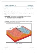
Water divide: Any elevated area, such as a mountain or an upland, separates two drainage
basins, such an upland is known as a water divide.
Figure 1: Water Divide
CHAPTER-3 DRAINAGE RAHAT JAHAN
,Drainage Systems in India
The Indian rivers are divided into two major groups:
The Himalayan rivers
The Peninsular rivers
The Himalayan rivers The Peninsular rivers
Most of the Himalayan rivers are perennial, which Peninsular rivers are seasonal.
means they have water throughout the year.
These rivers receive water from rain as well as from The flow of these rivers is dependent on rainfall.
melted snow from high mountains.
Two major Himalayan rivers, the Indus and the Most of the rivers of peninsular India originate in
Brahmaputra originate from the north of the the Western Ghats and flow towards the Bay of
mountain ranges. Bengal.
The Himalayan rivers have long and deep courses These rivers have shorter and shallower courses
from their source to the sea. as compared to the Himalayan rivers.
They cut through mountains making gorges. They do not make gorges.
They perform intensive erosional activity in their They do not perform intensive erosional activity.
upper courses and carry huge loads of silt and sand.
In middle and lower courses, rivers forms meanders, No such depositional features are formed by these
ox-bow lakes and other depositional features. rivers.
These rivers form deltas. These rivers form deltas and estuaries.
Examples are: the Indus, the Ganga and the Examples are: the Narmada, the Tapi, the
Brahmaputra. Krishna, the Godavari, etc,.
CHAPTER-3 DRAINAGE RAHAT JAHAN
, Figure 2: Delta and Estuary
Figure 3: A Gorge
CHAPTER-3 DRAINAGE RAHAT JAHAN
Class IX Subject: Geography
Drainage: The term drainage describes the river system of an area.
River system: A river along with a network of tributaries and distributaries is called a river
system.
Drainage basin: The area drained by a single river system is called a drainage basin.
The Amazon River is the world’s largest drainage basin.
The Ganga River has the largest drainage basin in India.
Water divide: Any elevated area, such as a mountain or an upland, separates two drainage
basins, such an upland is known as a water divide.
Figure 1: Water Divide
CHAPTER-3 DRAINAGE RAHAT JAHAN
,Drainage Systems in India
The Indian rivers are divided into two major groups:
The Himalayan rivers
The Peninsular rivers
The Himalayan rivers The Peninsular rivers
Most of the Himalayan rivers are perennial, which Peninsular rivers are seasonal.
means they have water throughout the year.
These rivers receive water from rain as well as from The flow of these rivers is dependent on rainfall.
melted snow from high mountains.
Two major Himalayan rivers, the Indus and the Most of the rivers of peninsular India originate in
Brahmaputra originate from the north of the the Western Ghats and flow towards the Bay of
mountain ranges. Bengal.
The Himalayan rivers have long and deep courses These rivers have shorter and shallower courses
from their source to the sea. as compared to the Himalayan rivers.
They cut through mountains making gorges. They do not make gorges.
They perform intensive erosional activity in their They do not perform intensive erosional activity.
upper courses and carry huge loads of silt and sand.
In middle and lower courses, rivers forms meanders, No such depositional features are formed by these
ox-bow lakes and other depositional features. rivers.
These rivers form deltas. These rivers form deltas and estuaries.
Examples are: the Indus, the Ganga and the Examples are: the Narmada, the Tapi, the
Brahmaputra. Krishna, the Godavari, etc,.
CHAPTER-3 DRAINAGE RAHAT JAHAN
, Figure 2: Delta and Estuary
Figure 3: A Gorge
CHAPTER-3 DRAINAGE RAHAT JAHAN


