
STD 9 Maths [Manjari] Total Marks : 8
* Case study based questions. [8]
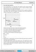
1. Arun is participating in an 8 miles walk. The organizers used a square coordinate
grid to plot the course. The starting point is at A (3, 1). At B (3, 4), there's a water
station to make sure the walkers stay hydrated.
From water station, the walkway turns right and at C(6, 4), a garden is situated to
keep walkers fresh. From the garden, the walkway turns left and finally, Arun
reaches at destination D to complete 8 miles.
Based on the above information, answer the following questions:
Q.1. How far is the water station B from the starting point A?
Q.2. How far is the water station B from garden C?
Q.3. What is the abscissa of destination point D?
Q.4. What are the coordinates of destination point D?
Ans. : 1. 3 miles
2. 3 miles
3. 6
4. (6, 6)
2. National Park: A national park is an area set aside by the government to preserve
and protect natural environment.
The graph below shows a map of the National Park. The shaded areas indicate
woods. The plain areas indicate meadows and fields without trees. Point O on the
graph represents the location of the park's supervisor's office, and points P and Q
are the ranger's towers.
Page 1
https://studentbro.in/
https://studentbro.in/
https://studentbro.in/
* Case study based questions. [8]
1. Arun is participating in an 8 miles walk. The organizers used a square coordinate
grid to plot the course. The starting point is at A (3, 1). At B (3, 4), there's a water
station to make sure the walkers stay hydrated.
From water station, the walkway turns right and at C(6, 4), a garden is situated to
keep walkers fresh. From the garden, the walkway turns left and finally, Arun
reaches at destination D to complete 8 miles.
Based on the above information, answer the following questions:
Q.1. How far is the water station B from the starting point A?
Q.2. How far is the water station B from garden C?
Q.3. What is the abscissa of destination point D?
Q.4. What are the coordinates of destination point D?
Ans. : 1. 3 miles
2. 3 miles
3. 6
4. (6, 6)
2. National Park: A national park is an area set aside by the government to preserve
and protect natural environment.
The graph below shows a map of the National Park. The shaded areas indicate
woods. The plain areas indicate meadows and fields without trees. Point O on the
graph represents the location of the park's supervisor's office, and points P and Q
are the ranger's towers.
Page 1
https://studentbro.in/
https://studentbro.in/
https://studentbro.in/


