

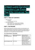
Oregon Land Surveying
Boundary Law Exam:
The Elite Universal Test
Bank
PART 0: TABLE OF CONTENTS
● (#part-i-the-preview)
○ The Mission
○ The "Critical Axioms" Cheat Sheet
● (#part-ii-the-elite-test-bank)
○ (#tier-1-questions-115---foundational-syntax--application)
○ (#tier-2-questions-1635---complex-application--simulation)
○ (#tier-3-questions-3660---grandmaster-synthesis)
PART I: THE PREVIEW
Mastering Oregon boundary law is not merely an exercise in memorizing statutes; it is the
rigorous, surgical application of legal frameworks to physical ground to protect enduring
property rights. By executing this comprehensive assessment, the practitioner hardwires the
analytical precision required to navigate complex cadastral regulations, defend boundary
determinations in court, and bulletproof their professional licensure.
The "Critical Axioms" Cheat Sheet
Core Doctrine Statutory/Legal Mechanism Operational Directive
The 45-Day Map Mandate ORS 209.250 A permanent map, or a
temporary map with a written
extension request (maximum
180 days), must be filed within
45 days of establishing a
boundary monument.
Adverse Possession Intent ORS 105.620 Post-1990 statutory claims
absolutely require the claimant
to possess an objective,
reasonable, and "honest belief"
of true ownership at the time of
,Core Doctrine Statutory/Legal Mechanism Operational Directive
entry.
The Priority of Calls Common Law / Rules of Natural Monuments > Artificial
Construction Monuments > Distances >
Bearings > Area. Physical
reality always supersedes
mathematical estimations.
Water Boundary Ambulation ORS 274 / Equal Footing Accretion (gradual change)
Doctrine shifts the boundary alongside
the water; Avulsion (sudden
change) freezes the boundary
at its historic location.
The OCRS Paradigm OAR 734-005-0010 The Oregon Coordinate
Reference System (OCRS)
utilizes low distortion
projections. Grid distances
inherently mirror ground
distances, rendering legacy
ellipsoid scaling obsolete.
PART II: THE ELITE TEST BANK
Tier 1 (Questions 1–15) - Foundational Syntax & Application
Q1: A registered professional land surveyor establishes a boundary monument. Due to
unforeseen weather, the survey map cannot be finalized within the statutory timeframe. Based
on the principles of ORS 209.250, which action is IMMEDIATELY required to maintain legal
compliance? A) Submit a permanent map of the survey within 90 days with an attached affidavit
of administrative delay. B) File an affidavit of correction with the State Board of Examiners within
30 days of the missed deadline. C) Provide written notice to the county surveyor within 45 days,
estimating completion within 180 days, and include a temporary map. D) Suspend all field
operations and notify adjoining landowners of the delay via certified mail.
● The Answer: C (Provide written notice to the county surveyor within 45 days, estimating
completion within 180 days, and include a temporary map.)
● Distractor Analysis:
○ A is incorrect: The statutory extension limit is 180 days, requiring an initial written
notice and a temporary map filed within the primary 45-day window, not a 90-day
grace period.
○ B is incorrect: Affidavits of correction apply to amending already filed permanent
maps, not circumventing expired filing deadlines.
○ D is incorrect: Notification to adjoining landowners is not a statutory requirement
under ORS 209 for mapping delays.
The Mentor's Analysis: The 45-day mapping rule is an absolute statutory ceiling. When field
operations stall, Oregon law strictly demands administrative transparency and an interim public
record to protect spatial data integrity. By utilizing the temporary map mechanism, the surveyor
bypasses the trap of regulatory non-compliance. Professional/Academic Intuition: Never
allow the 45-day statutory window to close without filing either a permanent map or a
temporary map.
, Q2: When analyzing conflicting elements within an 1890 property deed, which hierarchy reflects
the MOST ACCURATE priority of calls under established boundary law? A) Area > Bearings >
Distances > Artificial Monuments > Natural Monuments B) Natural Monuments > Artificial
Monuments > Distances > Bearings > Area C) Artificial Monuments > Natural Monuments >
Bearings > Distances > Area D) Bearings > Distances > Natural Monuments > Artificial
Monuments > Area
● The Answer: B (Natural Monuments > Artificial Monuments > Distances > Bearings >
Area)
● Distractor Analysis:
○ A is incorrect: This represents the exact inverse of the correct legal hierarchy. Area
is universally recognized as the least reliable element.
○ C is incorrect: Natural monuments control over artificial monuments because they
are inherently permanent and created by the earth, not man.
○ D is incorrect: Measurements (bearings and distances) always yield to the physical
certainty of monuments.
The Mentor's Analysis: Measurements contain inherent human error; the physical earth does
not. The priority of calls forms the bedrock of retracement surveying jurisprudence. By
prioritizing Natural Monuments, the surveyor respects the original intent over subsequent
mathematical miscalculations. Professional/Academic Intuition: Monuments control
measurements, and nature controls man.
Q3: A rural landowner attempts to claim title to an adjacent unmonumented strip of land via
statutory adverse possession under ORS 105.620. Their sole evidence of possession is the
seasonal grazing of cattle over a 12-year period. Based on Oregon statute, which conclusion is
the MOST ACCURATE? A) The claim succeeds because the land use exceeds the 10-year
continuous possession requirement. B) The claim succeeds because livestock grazing
establishes open and notorious dominion. C) The claim fails because the grazing of livestock,
absent additional supporting facts, is statutorily insufficient. D) The claim fails because adverse
possession requires a 15-year vesting period in rural zones.
● The Answer: C (The claim fails because the grazing of livestock, absent additional
supporting facts, is statutorily insufficient.)
● Distractor Analysis:
○ A is incorrect: Time alone cannot cure the statutory insufficiency of the specific
possessory act (grazing).
○ B is incorrect: While grazing is a visible activity, ORS 105.620(2)(b) explicitly
legislates that it is insufficient on its own.
○ D is incorrect: The vesting period for adverse possession in Oregon is strictly 10
years, not 15 years.
The Mentor's Analysis: Boundary disputes in rural regions frequently rely on informal fencing
and seasonal grazing. The legislature explicitly neutralized this common occurrence to protect
vast agricultural tracts. By demanding additional supporting facts, the law prevents the
accidental forfeiture of title through casual use. Professional/Academic Intuition: Livestock do
not capture title; adverse possession demands profound, unequivocal dominion.
Q4: Under ORS 209.150, a road construction crew accidentally destroys a public land survey
corner monument. The responsible agency hires a registered professional land surveyor to
restore it. What is the maximum statutory timeframe allowed to reference and replace the
destroyed monument? A) 30 days B) 45 days C) 90 days D) 180 days
● The Answer: C (90 days)
● Distractor Analysis:
Boundary Law Exam:
The Elite Universal Test
Bank
PART 0: TABLE OF CONTENTS
● (#part-i-the-preview)
○ The Mission
○ The "Critical Axioms" Cheat Sheet
● (#part-ii-the-elite-test-bank)
○ (#tier-1-questions-115---foundational-syntax--application)
○ (#tier-2-questions-1635---complex-application--simulation)
○ (#tier-3-questions-3660---grandmaster-synthesis)
PART I: THE PREVIEW
Mastering Oregon boundary law is not merely an exercise in memorizing statutes; it is the
rigorous, surgical application of legal frameworks to physical ground to protect enduring
property rights. By executing this comprehensive assessment, the practitioner hardwires the
analytical precision required to navigate complex cadastral regulations, defend boundary
determinations in court, and bulletproof their professional licensure.
The "Critical Axioms" Cheat Sheet
Core Doctrine Statutory/Legal Mechanism Operational Directive
The 45-Day Map Mandate ORS 209.250 A permanent map, or a
temporary map with a written
extension request (maximum
180 days), must be filed within
45 days of establishing a
boundary monument.
Adverse Possession Intent ORS 105.620 Post-1990 statutory claims
absolutely require the claimant
to possess an objective,
reasonable, and "honest belief"
of true ownership at the time of
,Core Doctrine Statutory/Legal Mechanism Operational Directive
entry.
The Priority of Calls Common Law / Rules of Natural Monuments > Artificial
Construction Monuments > Distances >
Bearings > Area. Physical
reality always supersedes
mathematical estimations.
Water Boundary Ambulation ORS 274 / Equal Footing Accretion (gradual change)
Doctrine shifts the boundary alongside
the water; Avulsion (sudden
change) freezes the boundary
at its historic location.
The OCRS Paradigm OAR 734-005-0010 The Oregon Coordinate
Reference System (OCRS)
utilizes low distortion
projections. Grid distances
inherently mirror ground
distances, rendering legacy
ellipsoid scaling obsolete.
PART II: THE ELITE TEST BANK
Tier 1 (Questions 1–15) - Foundational Syntax & Application
Q1: A registered professional land surveyor establishes a boundary monument. Due to
unforeseen weather, the survey map cannot be finalized within the statutory timeframe. Based
on the principles of ORS 209.250, which action is IMMEDIATELY required to maintain legal
compliance? A) Submit a permanent map of the survey within 90 days with an attached affidavit
of administrative delay. B) File an affidavit of correction with the State Board of Examiners within
30 days of the missed deadline. C) Provide written notice to the county surveyor within 45 days,
estimating completion within 180 days, and include a temporary map. D) Suspend all field
operations and notify adjoining landowners of the delay via certified mail.
● The Answer: C (Provide written notice to the county surveyor within 45 days, estimating
completion within 180 days, and include a temporary map.)
● Distractor Analysis:
○ A is incorrect: The statutory extension limit is 180 days, requiring an initial written
notice and a temporary map filed within the primary 45-day window, not a 90-day
grace period.
○ B is incorrect: Affidavits of correction apply to amending already filed permanent
maps, not circumventing expired filing deadlines.
○ D is incorrect: Notification to adjoining landowners is not a statutory requirement
under ORS 209 for mapping delays.
The Mentor's Analysis: The 45-day mapping rule is an absolute statutory ceiling. When field
operations stall, Oregon law strictly demands administrative transparency and an interim public
record to protect spatial data integrity. By utilizing the temporary map mechanism, the surveyor
bypasses the trap of regulatory non-compliance. Professional/Academic Intuition: Never
allow the 45-day statutory window to close without filing either a permanent map or a
temporary map.
, Q2: When analyzing conflicting elements within an 1890 property deed, which hierarchy reflects
the MOST ACCURATE priority of calls under established boundary law? A) Area > Bearings >
Distances > Artificial Monuments > Natural Monuments B) Natural Monuments > Artificial
Monuments > Distances > Bearings > Area C) Artificial Monuments > Natural Monuments >
Bearings > Distances > Area D) Bearings > Distances > Natural Monuments > Artificial
Monuments > Area
● The Answer: B (Natural Monuments > Artificial Monuments > Distances > Bearings >
Area)
● Distractor Analysis:
○ A is incorrect: This represents the exact inverse of the correct legal hierarchy. Area
is universally recognized as the least reliable element.
○ C is incorrect: Natural monuments control over artificial monuments because they
are inherently permanent and created by the earth, not man.
○ D is incorrect: Measurements (bearings and distances) always yield to the physical
certainty of monuments.
The Mentor's Analysis: Measurements contain inherent human error; the physical earth does
not. The priority of calls forms the bedrock of retracement surveying jurisprudence. By
prioritizing Natural Monuments, the surveyor respects the original intent over subsequent
mathematical miscalculations. Professional/Academic Intuition: Monuments control
measurements, and nature controls man.
Q3: A rural landowner attempts to claim title to an adjacent unmonumented strip of land via
statutory adverse possession under ORS 105.620. Their sole evidence of possession is the
seasonal grazing of cattle over a 12-year period. Based on Oregon statute, which conclusion is
the MOST ACCURATE? A) The claim succeeds because the land use exceeds the 10-year
continuous possession requirement. B) The claim succeeds because livestock grazing
establishes open and notorious dominion. C) The claim fails because the grazing of livestock,
absent additional supporting facts, is statutorily insufficient. D) The claim fails because adverse
possession requires a 15-year vesting period in rural zones.
● The Answer: C (The claim fails because the grazing of livestock, absent additional
supporting facts, is statutorily insufficient.)
● Distractor Analysis:
○ A is incorrect: Time alone cannot cure the statutory insufficiency of the specific
possessory act (grazing).
○ B is incorrect: While grazing is a visible activity, ORS 105.620(2)(b) explicitly
legislates that it is insufficient on its own.
○ D is incorrect: The vesting period for adverse possession in Oregon is strictly 10
years, not 15 years.
The Mentor's Analysis: Boundary disputes in rural regions frequently rely on informal fencing
and seasonal grazing. The legislature explicitly neutralized this common occurrence to protect
vast agricultural tracts. By demanding additional supporting facts, the law prevents the
accidental forfeiture of title through casual use. Professional/Academic Intuition: Livestock do
not capture title; adverse possession demands profound, unequivocal dominion.
Q4: Under ORS 209.150, a road construction crew accidentally destroys a public land survey
corner monument. The responsible agency hires a registered professional land surveyor to
restore it. What is the maximum statutory timeframe allowed to reference and replace the
destroyed monument? A) 30 days B) 45 days C) 90 days D) 180 days
● The Answer: C (90 days)
● Distractor Analysis:


