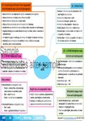
U4: Interpreting information from topographic U1: Contour lines
and orthophoto maps and aerial photographs
• Contours – lines on a map that join places of the
• Rural settlements are dispersed (far apart) or nucleated (close together). same height above sea level.
• Urban settlements are circular unless affected by relief. • Contour lines never cross or split.
• Rural settlements develop due to basic needs. • Contour lines far apart = gentle slope.
• Urban settlements develop due to the reason for its founding. • Contour lines close together = steep slope.
• Animal farms are identified on maps by fences, dams, reservoirs and wind pumps. • Evenly spaced contour lines = uniform slope.
• Irrigation farming shows canals/furrows leading from dams, rivers or reservoirs to • Concave slope - contours close at the top of a hill
cultivated land. and gentle at the bottom.
• The darker the grey of a built-up part of town, the higher the density of buildings. • Convex slope – contours are gentle at the top of a
• Industrial areas are found on the outskirts of cities, on flat land with good hill and close together at the bottom.
electricity, road and rail connections. •
Sample
U3: 1:50 000 Topographic maps
U2: 1:10 000 Orthophoto maps
Vertical aerial photographs
• Representative fractions (RFs) – the ratio of • Aerial photographs – taken from an aeroplane at
Summaries after sample
distance on a map to distance on the ground.
• 1:50 000 topographic maps have latitude and
longitude in degrees and minutes at the edges.
M1: Map
skills
different angles.
• Vertical aerial photographs are used to survey an
area from the air with an arial camera on a
stabilising mount in an aircraft pointing vertically
downward.
Map symbols: • Low oblique angle - < 45°.
• Natural features on topographic maps: • High oblique angle - > 45°.
o Brown – contour lines, rocky outcrops, •
Height clues on topographic maps:
sand, erosion and secondary roads. Orthophoto images made
o Blue – water features. • Height is shown by contours, trigonometrical from aerial photographs
o Green – natural features/vegetation. stations, spot heights and bench marks.
• Contours of a valley (point upstream) and • Aerial Orthophoto map – vertical aerial
• Constructed features on topographic maps: spurs (point downhill) also indicate height. photograph with contour lines and some other
o Red – roads. features of a topographic map.
o Green – agricultural features of vegetation. • They have spot heights, place names and route
• numbers.
•
GR9 SS T1-M1 Mind Map Spot On Copyright © www.summariessa.co.za (DO NOT COPY)
,Sample
Summaries after sample
and orthophoto maps and aerial photographs
• Contours – lines on a map that join places of the
• Rural settlements are dispersed (far apart) or nucleated (close together). same height above sea level.
• Urban settlements are circular unless affected by relief. • Contour lines never cross or split.
• Rural settlements develop due to basic needs. • Contour lines far apart = gentle slope.
• Urban settlements develop due to the reason for its founding. • Contour lines close together = steep slope.
• Animal farms are identified on maps by fences, dams, reservoirs and wind pumps. • Evenly spaced contour lines = uniform slope.
• Irrigation farming shows canals/furrows leading from dams, rivers or reservoirs to • Concave slope - contours close at the top of a hill
cultivated land. and gentle at the bottom.
• The darker the grey of a built-up part of town, the higher the density of buildings. • Convex slope – contours are gentle at the top of a
• Industrial areas are found on the outskirts of cities, on flat land with good hill and close together at the bottom.
electricity, road and rail connections. •
Sample
U3: 1:50 000 Topographic maps
U2: 1:10 000 Orthophoto maps
Vertical aerial photographs
• Representative fractions (RFs) – the ratio of • Aerial photographs – taken from an aeroplane at
Summaries after sample
distance on a map to distance on the ground.
• 1:50 000 topographic maps have latitude and
longitude in degrees and minutes at the edges.
M1: Map
skills
different angles.
• Vertical aerial photographs are used to survey an
area from the air with an arial camera on a
stabilising mount in an aircraft pointing vertically
downward.
Map symbols: • Low oblique angle - < 45°.
• Natural features on topographic maps: • High oblique angle - > 45°.
o Brown – contour lines, rocky outcrops, •
Height clues on topographic maps:
sand, erosion and secondary roads. Orthophoto images made
o Blue – water features. • Height is shown by contours, trigonometrical from aerial photographs
o Green – natural features/vegetation. stations, spot heights and bench marks.
• Contours of a valley (point upstream) and • Aerial Orthophoto map – vertical aerial
• Constructed features on topographic maps: spurs (point downhill) also indicate height. photograph with contour lines and some other
o Red – roads. features of a topographic map.
o Green – agricultural features of vegetation. • They have spot heights, place names and route
• numbers.
•
GR9 SS T1-M1 Mind Map Spot On Copyright © www.summariessa.co.za (DO NOT COPY)
,Sample
Summaries after sample