Geography: Geomorphology
Chapter 1: Drainage systems in South Africa
Drainage systems are river systems that “drain” water off land
Catchment area = the drainage area that supplies water to a river; the water comes from rainwater, which flows down the slope, and from
underground water, which seeps into the river.
Drainage basin = area drained by a river system
Source = place where a river begins
Mouth = where the river flows into a sea or lake
What happens to the precipitation that falls in a drainage basin?
Rainwater that does not infiltrate underground flows over the surface, eventually flows into sea.
Surface runoff = rainwater flower over the surface
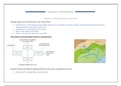
,Features of a drainage basin:
Watershed = high ground separating one drainage basin from the
adjacent drainage basin
Stream or river network = individual streams and rivers that are
connected
Tributaries = individual river channels forming the stream network
Confluence = point where one river in the network joins another
Interfluves = ridges of high ground between individual channels
Source (usually mountainous source)
River mouth
Important watersheds in SA:
- Drakensburg
- Witwatersrand
- Mountains south of plateau
Some rainwater may flow over the surface, creating small streams, and join to
form wider, deeper channels in which water flows as channel flow. Water can
also infiltrate soil as throughflow. Water could also infiltrate rocks underground
and become groundwater and flows as groundwater flow.
Overland flow = rainwater flowing over the surface
Channel flow = water flowing in a river channel
Throughflow = water flowing through the rocks
Groundwater flow = water flowing through underground rocks
Factors that determine how much water enters drainage basin + how much go into ground or flow on surface
, Relief - Steep gradient means more surface runoff, not enough time to infiltrate ground
Soil type - More surface runoff if soil is thin and not porous
Rock type - More surface runoff if rock is impermeable
Soil moisture - More surface runoff if soil is saturated, i.e. cannot absorb more water
Vegetation - More surface runoff if no vegetation does not allow for infiltration
Rainfall - Storms lead to more quick flowing water, therefore more surface runoff
Land use – More runoff in urban areas, concrete is impermeable
Water Table:
Water table = upper surface of groundwater
Water that infiltrate permeable rock come to a layer of impermeable rock.
This water then collects in pore spaces and cracks of permeable rocks.
Upper level of this saturated rock (no more water can be absorbed) is the
water table. When the water table lies above the bed of the river
groundwater will seep into the river as baseflow.
Baseflow = groundwater that seeps into a river
Not a lot of water in dry Bigger zone of
season, therefore not saturation (more water),
lots of the rock will get therefore a smaller
saturated, therefore water table
there is a bigger water
table
Unit 2: Types of rivers
Chapter 1: Drainage systems in South Africa
Drainage systems are river systems that “drain” water off land
Catchment area = the drainage area that supplies water to a river; the water comes from rainwater, which flows down the slope, and from
underground water, which seeps into the river.
Drainage basin = area drained by a river system
Source = place where a river begins
Mouth = where the river flows into a sea or lake
What happens to the precipitation that falls in a drainage basin?
Rainwater that does not infiltrate underground flows over the surface, eventually flows into sea.
Surface runoff = rainwater flower over the surface
,Features of a drainage basin:
Watershed = high ground separating one drainage basin from the
adjacent drainage basin
Stream or river network = individual streams and rivers that are
connected
Tributaries = individual river channels forming the stream network
Confluence = point where one river in the network joins another
Interfluves = ridges of high ground between individual channels
Source (usually mountainous source)
River mouth
Important watersheds in SA:
- Drakensburg
- Witwatersrand
- Mountains south of plateau
Some rainwater may flow over the surface, creating small streams, and join to
form wider, deeper channels in which water flows as channel flow. Water can
also infiltrate soil as throughflow. Water could also infiltrate rocks underground
and become groundwater and flows as groundwater flow.
Overland flow = rainwater flowing over the surface
Channel flow = water flowing in a river channel
Throughflow = water flowing through the rocks
Groundwater flow = water flowing through underground rocks
Factors that determine how much water enters drainage basin + how much go into ground or flow on surface
, Relief - Steep gradient means more surface runoff, not enough time to infiltrate ground
Soil type - More surface runoff if soil is thin and not porous
Rock type - More surface runoff if rock is impermeable
Soil moisture - More surface runoff if soil is saturated, i.e. cannot absorb more water
Vegetation - More surface runoff if no vegetation does not allow for infiltration
Rainfall - Storms lead to more quick flowing water, therefore more surface runoff
Land use – More runoff in urban areas, concrete is impermeable
Water Table:
Water table = upper surface of groundwater
Water that infiltrate permeable rock come to a layer of impermeable rock.
This water then collects in pore spaces and cracks of permeable rocks.
Upper level of this saturated rock (no more water can be absorbed) is the
water table. When the water table lies above the bed of the river
groundwater will seep into the river as baseflow.
Baseflow = groundwater that seeps into a river
Not a lot of water in dry Bigger zone of
season, therefore not saturation (more water),
lots of the rock will get therefore a smaller
saturated, therefore water table
there is a bigger water
table
Unit 2: Types of rivers