Geography: Climate and Weather
Chapter 1: Mid-lati tude Cyclones
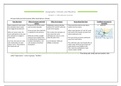
Pressure belts and wind systems affect South Africa’s climate
How they form Effect of pressure and wind Effect of air masses Areas where they form Conditions necessary for
pattern formation
Warm tropical air mass meets Pressure is low at the centre Midlatitude cyclones develop They move from west to east. Occur Jetstream
the cold polar mass in polar and increases outwards between 40° and 60° north and mainly over the oceans
front triggered by jetstream. south of the equator.
Pressure lower than 1000 hPa Affect areas between 35° and 70° north
When air masses meet, the is regarded as low pressure. This is where the cold polar air and south of the equator at polar front
warm subtropical air rises and mass meets the warm (where jetstreams are).
the cold polar air wedges in Winds do not blow straight subtropical air mass in a zone
underneath. along pressure gradient due called the polar front. The warm fronts are bent southwards
to Coriolis force. (Clockwise in away from South Africa.
As it rises, the warm air cools Southern Hemisphere, and Can be between 1000 and
and condensation of water anti-clockwise in Northern 3000km in diameter The cold fronts only reach South Africa in
vapour occurs. This produces Hemisphere winter when all the pressure belts and
the clouds and rain. wind systems move slightly north.
This is why the southwestern Cape
receives winter rainfall.
Mid-latitude cyclone = a low-pressure cell which develops in the mid-latitudes and travel from west to east. They bring cold, windy and wet weather. Also
called “depressions”. Come in groups: “families”
,Coriolis force = force that cause the deflection of moving objects due to the rotation of Earth on its axis, greatest at poles, least at equator
Polar front = a zone where the cold polar mass meets the warm tropical air mass
Jet stream = a band of strong westerly winds high in the atmosphere, which partly controls development of mid-latitude cyclones
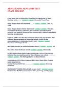
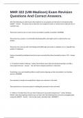
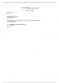
Unit 4: Stages of developemnt and related weather conditi ons (Southern Hemisphere)
Bend forms in polar front
1. Initial Stage Low pressure cell forms, winds deflect and blow into cell.
Moist air rises and cools
Weather: Start of strengthening winds, clouds appear
Bend deepens and pressure gradient increases
2. Mature Stage Air blows clockwise into the cell
Polar front now forms a cold front and a warm front
The fronts divide into a warm and cold sector
Weather: Cold sector = strong winds, overcast skies. Warm sector = warm weather and broken cloud
Warm sector air rises and cold sector air wedges underneath it
3. Partially occluded Stage Warm sector narrows as cold front overtakes it, eventually there is mainly cold air on the ground
Weather: Cold with nimbus clouds and light rain
Cyclone ends up as a little gust of cold air on ground level
4. Degeneration Stage Warm air has lifted high above ground
Pressure cells disappear, isobars even out
Weather: Cold with clouds and rain clearing
, Cold front = the border zone between a cold air mass and a warm air mass. Winds in the cold sector blow against the cold front
Initial Stage Partially occluded Stage
Warm front = the border zone between a warm air mass and a cold air mass. Winds in the warm sector blow against the warm front
Mature Stage
Warm sector = the area on the ground affected by warm air in a mid-latitude cyclone
Cold sector = the area on the ground affected by cold air in a mid-latitude cycloone
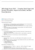
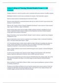
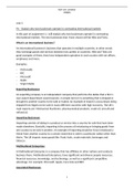
Cold fronts and Warm fronts:
Cold Fronts: Warm fronts:
Moves west to east. If you stand at X, the weather you will experience include: Moves west to eat. Standing at X you will experience:
Temperature decrease as cold front passes (from warm to cold sector) Temperature increase as warm front passes (from cold to warm
Pressure decrease as cold front approaches and increase as cold sector)
sector comes (pressure rises with increasing temperatures) Pressure decrease as warm sector arrives
Humidity decreases as cold sector comes (cold air holds less water Humidity increase as warm sector arrives
vapour) Warm. Moist, unstable air is lifted up the warm front. However,
Warm, moist, unstable air in warm sector is lifted up the front. Front is different clouds form along front (gradient of warm front is gentler)
steep so uplift is intense. Air cools + condenses to form cumulonimbus Cirrus and altostratus clouds appear. Later nimbostratus clouds appear
clouds (rain and thunderstorms occur) (soft, soaking rain)
Wind direction changes: “backs”. Blows Northeast, West, Southwest
(anticlockwise direction). In Northern hemisphere, the wind “veers” in
a clockwise direction
Chapter 1: Mid-lati tude Cyclones
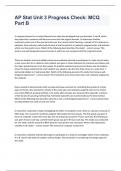
Pressure belts and wind systems affect South Africa’s climate
How they form Effect of pressure and wind Effect of air masses Areas where they form Conditions necessary for
pattern formation
Warm tropical air mass meets Pressure is low at the centre Midlatitude cyclones develop They move from west to east. Occur Jetstream
the cold polar mass in polar and increases outwards between 40° and 60° north and mainly over the oceans
front triggered by jetstream. south of the equator.
Pressure lower than 1000 hPa Affect areas between 35° and 70° north
When air masses meet, the is regarded as low pressure. This is where the cold polar air and south of the equator at polar front
warm subtropical air rises and mass meets the warm (where jetstreams are).
the cold polar air wedges in Winds do not blow straight subtropical air mass in a zone
underneath. along pressure gradient due called the polar front. The warm fronts are bent southwards
to Coriolis force. (Clockwise in away from South Africa.
As it rises, the warm air cools Southern Hemisphere, and Can be between 1000 and
and condensation of water anti-clockwise in Northern 3000km in diameter The cold fronts only reach South Africa in
vapour occurs. This produces Hemisphere winter when all the pressure belts and
the clouds and rain. wind systems move slightly north.
This is why the southwestern Cape
receives winter rainfall.
Mid-latitude cyclone = a low-pressure cell which develops in the mid-latitudes and travel from west to east. They bring cold, windy and wet weather. Also
called “depressions”. Come in groups: “families”
,Coriolis force = force that cause the deflection of moving objects due to the rotation of Earth on its axis, greatest at poles, least at equator
Polar front = a zone where the cold polar mass meets the warm tropical air mass
Jet stream = a band of strong westerly winds high in the atmosphere, which partly controls development of mid-latitude cyclones
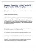
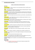
Unit 4: Stages of developemnt and related weather conditi ons (Southern Hemisphere)
Bend forms in polar front
1. Initial Stage Low pressure cell forms, winds deflect and blow into cell.
Moist air rises and cools
Weather: Start of strengthening winds, clouds appear
Bend deepens and pressure gradient increases
2. Mature Stage Air blows clockwise into the cell
Polar front now forms a cold front and a warm front
The fronts divide into a warm and cold sector
Weather: Cold sector = strong winds, overcast skies. Warm sector = warm weather and broken cloud
Warm sector air rises and cold sector air wedges underneath it
3. Partially occluded Stage Warm sector narrows as cold front overtakes it, eventually there is mainly cold air on the ground
Weather: Cold with nimbus clouds and light rain
Cyclone ends up as a little gust of cold air on ground level
4. Degeneration Stage Warm air has lifted high above ground
Pressure cells disappear, isobars even out
Weather: Cold with clouds and rain clearing
, Cold front = the border zone between a cold air mass and a warm air mass. Winds in the cold sector blow against the cold front
Initial Stage Partially occluded Stage
Warm front = the border zone between a warm air mass and a cold air mass. Winds in the warm sector blow against the warm front
Mature Stage
Warm sector = the area on the ground affected by warm air in a mid-latitude cyclone
Cold sector = the area on the ground affected by cold air in a mid-latitude cycloone
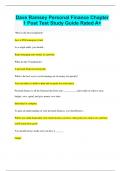
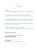
Cold fronts and Warm fronts:
Cold Fronts: Warm fronts:
Moves west to east. If you stand at X, the weather you will experience include: Moves west to eat. Standing at X you will experience:
Temperature decrease as cold front passes (from warm to cold sector) Temperature increase as warm front passes (from cold to warm
Pressure decrease as cold front approaches and increase as cold sector)
sector comes (pressure rises with increasing temperatures) Pressure decrease as warm sector arrives
Humidity decreases as cold sector comes (cold air holds less water Humidity increase as warm sector arrives
vapour) Warm. Moist, unstable air is lifted up the warm front. However,
Warm, moist, unstable air in warm sector is lifted up the front. Front is different clouds form along front (gradient of warm front is gentler)
steep so uplift is intense. Air cools + condenses to form cumulonimbus Cirrus and altostratus clouds appear. Later nimbostratus clouds appear
clouds (rain and thunderstorms occur) (soft, soaking rain)
Wind direction changes: “backs”. Blows Northeast, West, Southwest
(anticlockwise direction). In Northern hemisphere, the wind “veers” in
a clockwise direction