Geographical Mapwork Skill
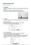
Types of Photograph
1. Horizonta
• This type of photograph is taken when the photographer stands on the
ground
• The axis of the camera is parallel to the ground surface.
• Uses: Features, vegetation, climate region, land use, season
2. Aeria
• Aerial photographs record the landscape as observed from an aircraf
a) High oblique Aeria
• This is when the camera is tilted at about 60o to the vertica
• The horizon can be seen on the photograph
b) Low oblique Aeria
• This is when the camera is tilted at about 30o to the vertica
• The horizon can’t be seen on the photograp
• oblique photographs are used to show large area, particularly features
such as communications, topography, vegetation and settlement
patterns
.
.
l
l
l
l
s
s
h
l
.
t
, Advantages of oblique photographs: Can see the height of building
Disadvantages of oblique photographs: Objects in the front block out
objects in the back, objects in the front look bigger than objects behind
3. Vertica
• This is when the camera is tilted at 90o to the earth’s surface.
Advantages
• The scale is accurat
• All objects can be see
• Used to draw topographic map
Disadvantages
• Dif cult to determine heigh
• Shadows obscure object
How aerial photographs are take
• Aerial photographs are taken by means of a special camera mounted
on an airplane
• The airplane is own at a constant altitude above sea level, NOT a
constant height above the ground
• The pilot ies in a pattern from east to west and west to east
• The photographs are taken in strips, each photograph overlaps the
one before by 60%. As the strip are completed the airplane turns
around and photographs the next strip. The two strips overlap by 30%
• Aerial photographs would be useful to cartographers, historians, town
planners, geographers, geologists, researchers
fi fll
:
.
:
fl e
n
s
t
s
.
n
.
.
s
.
.
, Orthophotos
An orthophoto is a black and white aerial photograph with a scale of
1:100000
Features
• 1cm= 100
• Contour interval = 5
• Spot heights and trig beacons are show
• The names of some roads are presen
• Some landmarks are name
Advantages
• Can see a lot more detail because of the large scale
• Orthophotos are produced more cheaply so they are quicker to
update
Scal
How much the actual area of the map has been shrunk to t on the map
is known as the scale of the map
• 1:350 000 000 is a smaller scale and 1:10 000 is a larger scale
• The larger the scale the less reality has been struck and thus the more
detail is shown
• The smaller the scale the more reality has been shrunk and thus the
less detail is shown
• In South Africa we use 1:50 000 topographic maps
1:50 000 map referencing system/map code/ grid referencin
Steps to complete a map code
1. Put your Latitude- oS
2. Put your longitude - oE
3. Split the single block up into 4 smaller blocks- A B C D
4. Split the single smaller block into 4 even smaller blocks- A B C D
5. Put a X into the correct block reference
6. EG 2531CC
e
.
:
.
m
:
.
.
.
m
.
.
d
:
.
t
.
n
.
.
.
fi .
g
.