Topic 3: Geomorphology
Unit 1: Drainage Systems in South Africa – Important Concepts
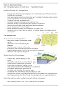
Landform features of a drainage basin:
- Drainage basin: the bowl-shaped depression from which water drains off the land; the area
occupied by a river system
- River system (stream network): a system made up of a number of individual stream channels
that join together that flows in a drainage basin
- Tributaries: rivers than join the main river
- Confluence: the point where one river joins the main river
- Watershed: the high ground separating two adjacent drainage basins
- Interfluve or spur: an area of high ground that separates tributaries
- Source: the place where the river begins
- Mouth: where the river ceases to flow and flows into a lake or sea
- Catchment area: the area of land that ‘catches’ the rain that falls and that supplies water to
a river system
The drainage basin:
The source of water in a drainage basin:
- Main source of water = precipitation (mainly
rainfall)
- Interception: water is intercepted by the
vegetation
- Retention: water is retained on the surface
- Evaporation: water evaporates back into the atmosphere
- Evapotranspiration: water is given off by plants and then evaporates
- Infiltration: water seeps into the ground
Surface Runoff and Groundwater:
- Overland flow: rainwater flowing over the
surface
- Channel flow: water flowing in a river channel
- Surface runoff or overland flow erode small
streams that eventually join together forming
wider, deeper channels in which water flows as channel flow
- Throughflow: water flowing through the soil
- Permeable rocks: rocks that allow water to seep in
- Groundwater flow: water flowing through underground rocks
- Rainwater may infiltrate as throughflow or percolate into permeable rocks underground and
become groundwater which flows through these underground rocks as groundwater flow
Factors that determine surface runoff and how much infiltrates underground:
- Relief: steeper gradient = more surface runoff (less time to infiltrate)
Unit 1: Drainage Systems in South Africa – Important Concepts
Landform features of a drainage basin:
- Drainage basin: the bowl-shaped depression from which water drains off the land; the area
occupied by a river system
- River system (stream network): a system made up of a number of individual stream channels
that join together that flows in a drainage basin
- Tributaries: rivers than join the main river
- Confluence: the point where one river joins the main river
- Watershed: the high ground separating two adjacent drainage basins
- Interfluve or spur: an area of high ground that separates tributaries
- Source: the place where the river begins
- Mouth: where the river ceases to flow and flows into a lake or sea
- Catchment area: the area of land that ‘catches’ the rain that falls and that supplies water to
a river system
The drainage basin:
The source of water in a drainage basin:
- Main source of water = precipitation (mainly
rainfall)
- Interception: water is intercepted by the
vegetation
- Retention: water is retained on the surface
- Evaporation: water evaporates back into the atmosphere
- Evapotranspiration: water is given off by plants and then evaporates
- Infiltration: water seeps into the ground
Surface Runoff and Groundwater:
- Overland flow: rainwater flowing over the
surface
- Channel flow: water flowing in a river channel
- Surface runoff or overland flow erode small
streams that eventually join together forming
wider, deeper channels in which water flows as channel flow
- Throughflow: water flowing through the soil
- Permeable rocks: rocks that allow water to seep in
- Groundwater flow: water flowing through underground rocks
- Rainwater may infiltrate as throughflow or percolate into permeable rocks underground and
become groundwater which flows through these underground rocks as groundwater flow
Factors that determine surface runoff and how much infiltrates underground:
- Relief: steeper gradient = more surface runoff (less time to infiltrate)