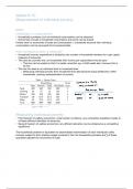
HURRICANE KATRINA CASE STUDY
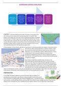
August 25th -
August 29th -
strengthened into August 27th -
August 23rd - August 26th - made 2nd
a hurricane and 18,000 cars an
Katrina orginates Katrina emerged landfall as a
made landfall at hour evacuating
over The onto the Gulf of category 3
Hallandale due to evacuation
Bahamas as a Mexico as a hurricane in
Beach, Florida. notices being
depression. tropical storm. South East
80mph wind enforced.
Louisiana.
speeds.
CONTEXT – Hurricane Katrina hit the state of Louisiana in the south of the
USA. Hurricane force winds were recorded along 200m of coastline. New
Orleans is the largest city in the state, with an es%mated popula%on of 393,000
and more than 1.2 million living in the surrounding metropolitan area. The city
of New Orleans has a poverty rate of 23.2% (twice the na%onal average), which
majorly affected the impact hurricane Katrina had on the popula%on. The black
popula%on of New Orleans is 59.8%, and an Asian popula%on of 3%. The city
has a popula%on density of 2,292 people per square mile.
Of the popula%on of New Orleans, 20% did not have access to cars/ transporta%on (due largely to the poverty rate in
New Orleans). Many people depended on well-fare cheques, which
due to the %me of the month the hurricane occurred, would most
likely have run out and le8 them unable to afford transport or hotels
in other places. This reduced the effec%veness of the whole
emergency strategy because the plan relied on people being able to
leave the city – this should have been considered by those developing
emergency strategies.
New Orleans is built almost en%rely below sea level, on the
Mississippi Delta. The Mississippi basin drains 1/3 of the United
States, so it has a flow rate of approximately 600,000 cubic feet per
second. It is shaped like a crescent, so is almost surrounded by water,
with Lake Pontchartrain (which covers an area of 630 square miles)
just above the city. It has the worlds largest system of levees, some of
which are sinking due to erosion, and some are damaged due to lack of funding to repair them. The ninth ward (one
of the poorest communi%es in New Orleans) has most of its housing 48 below sea level.
PREPARATION.
In July 2004, The States modelled a hurricane (Hurricane Pam) of category 5. It
es%mated that with the best, most efficient response possible, the hurricane would
cause the death of 61,000 people, and destroyed 500,000 homes. It showed that levees
were overcame and flooded New Orleans, but they didn’t think that the levees needed repairing. If they had been
willing to learn and adapt from this modelling, then the impacts of Katrina may not have been as detrimental.