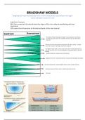
BRADSHAW MODELS
Geographical model that describes how a rivers characteristic vary between the upper
course and lower course of a river
Load from 2 sources:
90% from movement of material down the slopes of the river valley by weathering and mass
movement
10% comes from the erosion of the bed and banks of the river channel.
¸
The volume of water that passes through a cross-section per unit of time]
increases due to the input from a greeter amount of the river basin above
that point
Distance across the actual channel measured at the water surface . Increases
due to the increase in discharge, input from tributaries
The height from the water surface to the stream bed. increase downstream as
does the size of the river. Line connecting places of greatest depth is called the
thalweg
Speed of water flow. Steady increase downstream.
Capacity of the river. Total load of all sizes. Increases with discharge and velocity
Decreases downstream. Angular pebbles become more rounded. Attrition
Decreases because of fewer stones. Smaller load particle size etc
Decreases
, WHAT IS GIS? RESOLUTION
Using computers, a gis processes huge - takes 3 forms
volumes of spatially-referenced data and CONCEPTS: SPATIAL – refers to the size of the object that can be recorded:
analyses spatial location and organizes layers REMOTE SENSING? and the mostly measured in pixel size. Many pixels will be
of information into visualizations using maps Aircraft and satellites collect data about used to make hp a high-resolution image.
and 3d scenes. for use in more efficient features of the earth without coming in SPECTRAL - refers to the width of the wavelength intervals
management of the environment, resources contact with them. that are being measured in the electromagnetic spectrum.
and the economy. Every surface reflects electromagnetic TEMPORAL - (AKA repeat cycle or orbital) describes the
energy, instruments (remote sensors) frequency with which images are collected for the same area.
WHAT IS IT USED FOR? measure this energy.
USES? § Measures the electromagnetic
Identify problems, monitor change, manage radiation that is: emitted by the PIXEL
and respond to events, forecasting and sun and then reflected back -Short for pix and element: the smallest single elements in an
understand trends. into space continuously. image on a computer screen. Each pixel has an address defined
Collect data from satelites to make best use of § Emitted by satellite in the form by its coordinates
resources. of microwave energy that is
Help find the best sites for photovoltaic solar reflected back to the satellite. DATA
panels to reduce the use of fossil fuels SPATIAL
Collect atmospheric data and change in global GEOGRAPHICAL Data or info that identifies the geographic location and
average temperature boundaries of features on earth. Usually stored as
Aquaculture is the farming aquatic organisms INFORMATION SYSTEMS coordinates and altitude.
DATA STANDARDISATION: RASTER ATTRIBUTE
- Global map projections used Each given is divided into rectangular grid cells, Descriptive information about spatial objects i.e. income
- Methods of georeferencing which are sometimes referred to as pixels. Each levels, unemployment, soil loss, mean temperatures.
- Geographical names cell in the grid contains attribute value and its
- Units of measurement used location coordinates. i.e. digital images from
- Terms used satellites VECTOR
- Method and processing digital data Advantages Uses points, lines and areas inside polygons to define data
– simple data structure stored on a computer
-Efficient for remotely sensed or scanned data Advantages
DATA SHARING: -point, line and area data shown more correctly.
-Simple GIS analysis
Data available to people all over the world, avoids -Needs less disk storage space for data
Disadvantages
expensive repitition of data, reduces workload and costs - Needs more storage space on computer -Lines (like roads) and areas fit together correctly.
-Pixels are big = graphics less pleasing -Graphics look more like hand drawn maps
-Projection transformations can be difficult Disadvantages
DATA SECURITY – more complex data structure
-Lines and areas don’t fit together well
- Aircraft control, defence and crime detection -Inefficient for remotely – sensed data
VECTOR AND RASTER BEST USES
- Backed up Detached features -Some GIS procedures are more complex and slower
- Secure from fraud -Overlaying multiple vector maps is time consuming
Areas with precise boundaries