scale and type - correct answer-How are military maps categorized?
small, medium, large - correct answer-different scale categories for military maps
small (scale) - correct answer-Maps with scales of 1:1,000,000 and smaller are used for general planning
and strategic studies
medium (scale) - correct answer-Maps with scales between 1:1,000,000 and 1:75,000 are used for
operational planning
large (scale) - correct answer-Maps with scales of 1:75,000 and larger are used for tactical,
administrative, and logistical planning
topographic, digital, terrain model - correct answer-different type categories for military maps
grid zone designators - correct answer-Two letter prefix prior to grid coordinate, found in the grid
reference box
4 digit grid coordinate - correct answer-within 1,000 meters of your point
, 6 digit grid coordinate - correct answer-within 100 meters of your point
8 digit grid coordinate - correct answer-within 10 meters of your point
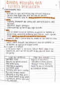
Hill
Valley
Ridge
Saddle
Depression - correct answer-five major terrain features (hidden valley ranch salad dressing)
spur, draw, cliff - correct answer-three minor terrain features
cut, fill - correct answer-two supplemental terrain features
ridge - correct answer-a line of high ground with height variations along its crest, all points of crest are
higher than the ground on both sides of this terrain feature
, hill - correct answer-a point of small area of high ground, ground slopes down in all directions at the
peak
saddle - correct answer-a dip or low point along the crest of a ridge, not necessarily the lower ground
between two hilltops, may be a break along an otherwise level ridge crest
valley - correct answer-reasonably level ground bordered on the sides by higher ground, may or may not
contain a stream course, generally has maneuver room within its confines, contour lines are U-shaped
and tend to parallel a stream before crossing it, course of the contour line crossing the stream always
points upstream
depression - correct answer-low point or hole in the ground, surrounded on all sides by higher ground
spurs - correct answer-usually a short continuously sloping line of higher ground, normally jutting out
from the side of a ridge, often formed by two thoroughly parallel streams cutting draws down the side
of a ridge
draws - correct answer-similar to a valley, except that it normally is a less developed stream course in
which there is generally no level ground and, therefore, little or no maneuver room, ground slopes
upward on each side and toward the head of this terrain feature, caused by flash floods, can be found
small, medium, large - correct answer-different scale categories for military maps
small (scale) - correct answer-Maps with scales of 1:1,000,000 and smaller are used for general planning
and strategic studies
medium (scale) - correct answer-Maps with scales between 1:1,000,000 and 1:75,000 are used for
operational planning
large (scale) - correct answer-Maps with scales of 1:75,000 and larger are used for tactical,
administrative, and logistical planning
topographic, digital, terrain model - correct answer-different type categories for military maps
grid zone designators - correct answer-Two letter prefix prior to grid coordinate, found in the grid
reference box
4 digit grid coordinate - correct answer-within 1,000 meters of your point
, 6 digit grid coordinate - correct answer-within 100 meters of your point
8 digit grid coordinate - correct answer-within 10 meters of your point
Hill
Valley
Ridge
Saddle
Depression - correct answer-five major terrain features (hidden valley ranch salad dressing)
spur, draw, cliff - correct answer-three minor terrain features
cut, fill - correct answer-two supplemental terrain features
ridge - correct answer-a line of high ground with height variations along its crest, all points of crest are
higher than the ground on both sides of this terrain feature
, hill - correct answer-a point of small area of high ground, ground slopes down in all directions at the
peak
saddle - correct answer-a dip or low point along the crest of a ridge, not necessarily the lower ground
between two hilltops, may be a break along an otherwise level ridge crest
valley - correct answer-reasonably level ground bordered on the sides by higher ground, may or may not
contain a stream course, generally has maneuver room within its confines, contour lines are U-shaped
and tend to parallel a stream before crossing it, course of the contour line crossing the stream always
points upstream
depression - correct answer-low point or hole in the ground, surrounded on all sides by higher ground
spurs - correct answer-usually a short continuously sloping line of higher ground, normally jutting out
from the side of a ridge, often formed by two thoroughly parallel streams cutting draws down the side
of a ridge
draws - correct answer-similar to a valley, except that it normally is a less developed stream course in
which there is generally no level ground and, therefore, little or no maneuver room, ground slopes
upward on each side and toward the head of this terrain feature, caused by flash floods, can be found