TEMA 3
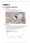
3.1 – MÉTODO DE ITINERARIOS
CONDICIONES:
1. Es necesario observar una serie de puntos.
2. No es posible observar todos los puntos desde un único punto E.
3. Es necesario realizar varios cambios de estación.
CARACTERÍSTICAS:
• El error sufre un encadenamiento, al determinar un punto se transmite a los siguientes.
• Al posicionar el equipo en puntos diferentes se cambia el sistema de referencia.
• Método utilizado principalmente en el cálculo de redes de segundo orden.
• Utiliza coordenadas polares en las observaciones de campo.
• Es una sucesión encadenada de radiaciones.
→ ESTACIONES: Los puntos A, B, C…
→ TRAMOS O EJES: Las distancias AB, BC, CD…
,CLASIFICACIÓN:
• Itinerario cerrado.
Abiertos colgados.
• Itinerario abierto.
Abiertos encuadrados.
ITINERARIO ABIERTO
ITINERARIO CERRADO
ENLACE ENTRE ESTACIONES, MÉTODO DE MOINOT:
Es el método de observación más utilizado:
• Proporciona PRECISIÓN en las medidas.
• Se pueden realizar COMPROBACIONES.
Sistemática:
• En cada estación se observa al punto anterior y siguiente de la poligonal
aplicando la REGLA DE BESSEL:
o 4 medidas de distancia.
o 2 medidas de cada ángulo del itinerario.
• Se obtienen valores promedio únicos para esas medidas.
• Se manifiestan errores en las observaciones de campo, mejorando la precisión de
los resultados.
CLASIFICACIÓN CON ERRORES:
CON ERROR TOTAL ORIENTADO: θ< =
= = θ< ± 200
g
• Con brújula por estaciones recíprocas.
• Con brújula por estaciones alternas.
CON ERROR TOTAL DESORIENTADO:
• θ<= = θ<? + (L<= − L<? )
• θ<= = θ<? + Â 0
, PROCEDIMIENTO DE UNA POLIGONAL:
1. Hacer estación en el punto A.
2. Tomar una referencia angular (dirección AR). DATOS NECESARIOS:
3. Observar el punto B por radiación.
-Puntos y ejes que conformarán el
4. Hacer estación en el punto B.
itinerario.
5. Tomar la referencia angular (dirección BA).
-Acimutes de los distintos ejes del itinerario.
6. Observar el punto C por radiación.
7. Hacer estación en el punto C.
8. Tomar una referencia angular (dirección CB).
9. … etcétera.
CÁLCULO DE ACIMUTES, ERROR ANGULAR:
Punto A:
θ<= = θ<? + (L<= − L<? )
θ<= = θ<? + Â − 400
Punto B: θ=< = θ<= ± 200
θ=O = θ=< + (L=O − L=< )
θ=O = θ=< + B