AP HUMAN GEOGRAPHY QUARTER 1
EXAM QUESTIONS WITH CORRECT
ANSWERS
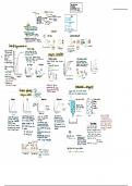
How do maps help describe where things are located - Answer-shows where thing and
places are, shows absolute location, displays features and patterns
What was early map making like? - Answer-it was hard, they were accurate in specific
places and were distorted everywhere because tech was not good and Earth was
believed to be flat
How does map scale impact our understanding and interpretation of different places -
Answer-scale is the relationship of a features size on a map to its actual size on Earth
- large scale : more Detail - small scale: less detail
What types of distortion can occur from map projection? Examples? - Answer-- Shape :
Florida is just u shape like on vals study guide
-Distance: Europe is too close to the U.s.
-Relative size: Australia is too big
-Direction
What are some contemporary tools for mapping Earth's surface and how d they differ
from one another? - Answer--Remote sensing:Data from satellites
- GPS : shows map to go somewhere
-GIS: computer system analyzes geographic data
- Mashups : overlaying data
What are the four way to identify location? - Answer--Name
-Absolute location
-Site
-Situation
what is the difference between site and situation? - Answer-Site: physical characteristics
of a place
Situation: location of a place relative to other places
What is the difference between latitude and longitude? - Answer-Longitude: North to
South
Latitude: West to East
How does one determine longitude? - Answer-Meridians, degrees
0 degrees is prime Meridian in Europe
What are the three types of regions? - Answer-Formal/union region
EXAM QUESTIONS WITH CORRECT
ANSWERS
How do maps help describe where things are located - Answer-shows where thing and
places are, shows absolute location, displays features and patterns
What was early map making like? - Answer-it was hard, they were accurate in specific
places and were distorted everywhere because tech was not good and Earth was
believed to be flat
How does map scale impact our understanding and interpretation of different places -
Answer-scale is the relationship of a features size on a map to its actual size on Earth
- large scale : more Detail - small scale: less detail
What types of distortion can occur from map projection? Examples? - Answer-- Shape :
Florida is just u shape like on vals study guide
-Distance: Europe is too close to the U.s.
-Relative size: Australia is too big
-Direction
What are some contemporary tools for mapping Earth's surface and how d they differ
from one another? - Answer--Remote sensing:Data from satellites
- GPS : shows map to go somewhere
-GIS: computer system analyzes geographic data
- Mashups : overlaying data
What are the four way to identify location? - Answer--Name
-Absolute location
-Site
-Situation
what is the difference between site and situation? - Answer-Site: physical characteristics
of a place
Situation: location of a place relative to other places
What is the difference between latitude and longitude? - Answer-Longitude: North to
South
Latitude: West to East
How does one determine longitude? - Answer-Meridians, degrees
0 degrees is prime Meridian in Europe
What are the three types of regions? - Answer-Formal/union region