, Annie and Harrison
Soil Erosion by water
Definition: detachment and removal of soil material by water
4 types:
1. Rill erosion
2. Sheet erosion
3. Gully erosion
4. River bank erosion
Rill erosion: occurs when run off water forms small channels (rills) as it concentrates down a slope - are not big enough to effect agriculture
Sheet erosion: detachment of soil particles due to rain action cases topsoil to transport in a uniform fashion
Gully erosion: rills can develop into larger gullies if they are left unattended and they pose as a threat to agriculture and farm machinery
River bank erosion: soil is removed by rivers as they meander across surrounding land
Problems for agriculture:
• Each year it destroys up to 75 billion tonnes of the fertile, nutrient rich topsoil that is needed for farming
o Seeds and plants are affected by this lack of natural nutrients
• This equates to 9 million hectares of productive land
• Reduces water quality and increases pollutants which negatively affects the biodiversity
• Structure of soil is weakened as layers are removed by the water
• Sediment that reaches streams can accelerate bank erosion, obstruct drainage and damage fish habitats
• Diminished water supply and quality
Management - The key to reducing soil erosion is to reduce the amount of surface flow of the water, demonstrated with these techniques
Grow forages
• Forages can be grown on poorer soils or steep slopes (not suitable for other crops).
• Forage cover protects the soil from erosion as the roots hold the soil in place.
• Forages also add organic matter, improving the quality of the soil to absorb more water and reduce runoff/erosion.
Crop Rotation
• Planting different crops (cereals) on the same plot to improve soil health, and optimise nutrients
• It also stabilises the soil and absorbs excess water
Direct seeding
• Annual crops such as barley, oats and peas can be directly seeded into pasture after the pasture vegetation has been killed by herbicide, using
glyphosate/roundup. Full spaying is preferred as it leads to better moisture conservation
Grassed waterways
• Wide, shallow grassed channel that can carry a large volume of water quickly down a steep slope.
• Used to carry peak runoff events, such as storms
Lined channels
• Ways of dropping water to lower elevations along steep parts of a waterway.
Terracing
• A channel with a 1m difference in elevation
• Built across the slope of the crops to intercept runoff
Drop structures
• Constructed along waterways to drop water to lower elevations without causing erosion. They are constructed of concrete, wood, metal or rock. Drop structures
are the most costly but can be most effective in most situations
• Cross section of a pipe drop structure - Less expensive and very effective. Water drains through small plastic pipe and runs under berm, down the slope and
outlets at the bottom
Planting lines of trees/hedgerows
• Trees can reduce evaporation by up to 20%
• This in return causes less precipitation and therefore less soil erosion
Case study – South Africa
• South Africa is the country most affected by rill and gully erosion.
• South Africa’s mainly produces peanuts, sunflowers, bean and soybeans
• This is because of the intensive agricultural culture, and overuse of the soil. This
in return makes the soil arid and more susceptible to soil erosion.
• The country Is now losing as much soil as it is gaining, making the soil and
farming techniques non sustainable.
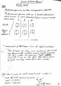
• The top map on the left show the distribution of soil loss, and the bottom map
shows the distribution of Gullies (which are landforms created by rubbing water
eroding sharply into the soil
• The top graph shows the provinces which have the most soil loss annually.
• The bottom graph on the right shows the provinces which are affected the most
by Gully erosion (which can be compared to the distribution of Gullies.
Soil Erosion by water
Definition: detachment and removal of soil material by water
4 types:
1. Rill erosion
2. Sheet erosion
3. Gully erosion
4. River bank erosion
Rill erosion: occurs when run off water forms small channels (rills) as it concentrates down a slope - are not big enough to effect agriculture
Sheet erosion: detachment of soil particles due to rain action cases topsoil to transport in a uniform fashion
Gully erosion: rills can develop into larger gullies if they are left unattended and they pose as a threat to agriculture and farm machinery
River bank erosion: soil is removed by rivers as they meander across surrounding land
Problems for agriculture:
• Each year it destroys up to 75 billion tonnes of the fertile, nutrient rich topsoil that is needed for farming
o Seeds and plants are affected by this lack of natural nutrients
• This equates to 9 million hectares of productive land
• Reduces water quality and increases pollutants which negatively affects the biodiversity
• Structure of soil is weakened as layers are removed by the water
• Sediment that reaches streams can accelerate bank erosion, obstruct drainage and damage fish habitats
• Diminished water supply and quality
Management - The key to reducing soil erosion is to reduce the amount of surface flow of the water, demonstrated with these techniques
Grow forages
• Forages can be grown on poorer soils or steep slopes (not suitable for other crops).
• Forage cover protects the soil from erosion as the roots hold the soil in place.
• Forages also add organic matter, improving the quality of the soil to absorb more water and reduce runoff/erosion.
Crop Rotation
• Planting different crops (cereals) on the same plot to improve soil health, and optimise nutrients
• It also stabilises the soil and absorbs excess water
Direct seeding
• Annual crops such as barley, oats and peas can be directly seeded into pasture after the pasture vegetation has been killed by herbicide, using
glyphosate/roundup. Full spaying is preferred as it leads to better moisture conservation
Grassed waterways
• Wide, shallow grassed channel that can carry a large volume of water quickly down a steep slope.
• Used to carry peak runoff events, such as storms
Lined channels
• Ways of dropping water to lower elevations along steep parts of a waterway.
Terracing
• A channel with a 1m difference in elevation
• Built across the slope of the crops to intercept runoff
Drop structures
• Constructed along waterways to drop water to lower elevations without causing erosion. They are constructed of concrete, wood, metal or rock. Drop structures
are the most costly but can be most effective in most situations
• Cross section of a pipe drop structure - Less expensive and very effective. Water drains through small plastic pipe and runs under berm, down the slope and
outlets at the bottom
Planting lines of trees/hedgerows
• Trees can reduce evaporation by up to 20%
• This in return causes less precipitation and therefore less soil erosion
Case study – South Africa
• South Africa is the country most affected by rill and gully erosion.
• South Africa’s mainly produces peanuts, sunflowers, bean and soybeans
• This is because of the intensive agricultural culture, and overuse of the soil. This
in return makes the soil arid and more susceptible to soil erosion.
• The country Is now losing as much soil as it is gaining, making the soil and
farming techniques non sustainable.
• The top map on the left show the distribution of soil loss, and the bottom map
shows the distribution of Gullies (which are landforms created by rubbing water
eroding sharply into the soil
• The top graph shows the provinces which have the most soil loss annually.
• The bottom graph on the right shows the provinces which are affected the most
by Gully erosion (which can be compared to the distribution of Gullies.