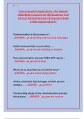
Geomorphology
Drainage systems in South Africa
Important concepts:
Baseflow: Groundwater that seeps into a river.
Catchment area: The area of land over which rain falls forming the drainage basin.
Cone of A depression in the groundwater table that has the shape
depression: of an inverted cone and develops around a well from
which water is being withdrawn.
Confluence: The place where two rivers join
Drainage basin: Area drained by a river system
Ground water: Water found under the ground
Impermeable rock: Do not have pore spaces or cracks through which water is able to pass
Infiltration: Movement of water through soil into the ground
Percolation: The process of a liquid moving slowly through a substance that has very small
holes in it
Permeable rock: Rocks which allow water to seep in
River mouth: Sea or lake where a river ends.
River system: A main river with all its tributaries:
Source: Where the river begins.
Springs: A place where water moving underground finds an opening to the land surface
and emerges
Surface run-off: Rainwater flowing over the surface.
Tributary: A river that joins another larger river.
Water shed: An area of high ground separating two
drainage basins.
Interfluve: Ridges of high ground between
individua channels
Water table: The upper level of underground saturated rock
Zone of aeration: The area of an unconfined aquifer above the water table where the pore spaces
among soil particles and rock formations are filled with air.
Zone of saturation: The zone of saturation is the ground
immediately below the water table. The pores
and fractures in soil and rocks are saturated
with water.
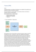
Input, Storage, Flows/transfers, and output of a river system:
Page | 1
, Types of rivers:
Perennial Rivers:
Permanent rivers flow all year round and are always in contact with the water table e.g., The Tugela River.
Exotic rivers span two types of climatic regions. These rivers usually rise in high rainfall areas and flow
into dry regions The Orange River (or Gariep) rises in Lesotho and flows through the drier western side
(Northern Cape) before it reaches the Atlantic Ocean.
Non-Perennial rivers:
Periodic rivers only flow during the rainy season. They are in contact
with the water table and receive groundwater only in the rainy
season e.g., The Limpopo River.
Episodic rivers only flow after heavy rain (not from underground water). The water table is below the
riverbed. These rivers are found in regions where there is low rainfall, which evaporates quickly e.g., The
Auob and Nossob Rivers of the Kalahari in Northern Cape.
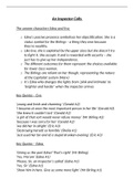
Drainage patterns:
Pattern Picture Requirements Characteristics
• Forms on sedimentary,
igneous, or metamorphic • Most common
Dendritic rocks • Flows randomly
• Rock is uniformly resistant to • Tree shaped
erosion
• Main streams flow
• Found in valleys or folded
parallel to each other
mountains
Trellis • Tributaries are short
• Occurs on alternate bands of
and join the mainstream
hard and soft rock
at 90°
• Well jointed rocks with
• Streams have 90° bends
Rectangular joints/faults exposed at the
along their course
surface
• Streams radiate
• Dome shaped hill, mesa, butte,
Radial outwards from a high
or conical hill
central point.
• Streams radiate
• A central basin or low-lying inwards from
Centripetal
area such as a lake or marsh surrounding higher
areas
• Has irregular route with
swamps and lakes
Deranged • Geologically young areas
• No direction
• Haphazard pattern
• Main streams flow
• Recently uplifted sloping plain
parallel to each other,
Parallel • Rock type uniformly resistant
and tributaries join at
to erosion
very small angles
Page | 2
Drainage systems in South Africa
Important concepts:
Baseflow: Groundwater that seeps into a river.
Catchment area: The area of land over which rain falls forming the drainage basin.
Cone of A depression in the groundwater table that has the shape
depression: of an inverted cone and develops around a well from
which water is being withdrawn.
Confluence: The place where two rivers join
Drainage basin: Area drained by a river system
Ground water: Water found under the ground
Impermeable rock: Do not have pore spaces or cracks through which water is able to pass
Infiltration: Movement of water through soil into the ground
Percolation: The process of a liquid moving slowly through a substance that has very small
holes in it
Permeable rock: Rocks which allow water to seep in
River mouth: Sea or lake where a river ends.
River system: A main river with all its tributaries:
Source: Where the river begins.
Springs: A place where water moving underground finds an opening to the land surface
and emerges
Surface run-off: Rainwater flowing over the surface.
Tributary: A river that joins another larger river.
Water shed: An area of high ground separating two
drainage basins.
Interfluve: Ridges of high ground between
individua channels
Water table: The upper level of underground saturated rock
Zone of aeration: The area of an unconfined aquifer above the water table where the pore spaces
among soil particles and rock formations are filled with air.
Zone of saturation: The zone of saturation is the ground
immediately below the water table. The pores
and fractures in soil and rocks are saturated
with water.
Input, Storage, Flows/transfers, and output of a river system:
Page | 1
, Types of rivers:
Perennial Rivers:
Permanent rivers flow all year round and are always in contact with the water table e.g., The Tugela River.
Exotic rivers span two types of climatic regions. These rivers usually rise in high rainfall areas and flow
into dry regions The Orange River (or Gariep) rises in Lesotho and flows through the drier western side
(Northern Cape) before it reaches the Atlantic Ocean.
Non-Perennial rivers:
Periodic rivers only flow during the rainy season. They are in contact
with the water table and receive groundwater only in the rainy
season e.g., The Limpopo River.
Episodic rivers only flow after heavy rain (not from underground water). The water table is below the
riverbed. These rivers are found in regions where there is low rainfall, which evaporates quickly e.g., The
Auob and Nossob Rivers of the Kalahari in Northern Cape.
Drainage patterns:
Pattern Picture Requirements Characteristics
• Forms on sedimentary,
igneous, or metamorphic • Most common
Dendritic rocks • Flows randomly
• Rock is uniformly resistant to • Tree shaped
erosion
• Main streams flow
• Found in valleys or folded
parallel to each other
mountains
Trellis • Tributaries are short
• Occurs on alternate bands of
and join the mainstream
hard and soft rock
at 90°
• Well jointed rocks with
• Streams have 90° bends
Rectangular joints/faults exposed at the
along their course
surface
• Streams radiate
• Dome shaped hill, mesa, butte,
Radial outwards from a high
or conical hill
central point.
• Streams radiate
• A central basin or low-lying inwards from
Centripetal
area such as a lake or marsh surrounding higher
areas
• Has irregular route with
swamps and lakes
Deranged • Geologically young areas
• No direction
• Haphazard pattern
• Main streams flow
• Recently uplifted sloping plain
parallel to each other,
Parallel • Rock type uniformly resistant
and tributaries join at
to erosion
very small angles
Page | 2