- Facilities
- Provide goods and/or services
- Demand points
- Consume goods and/or services
- Goal of location-allocation: locate the facilities in a way
that supplies the demand points most efficiently
- Twofold problem: simultaneously locates facilities and
allocates the demand points to the facilities
Location-allocation refers to algorithms
used primarily in a GIS to determine an
optimal location for one or more facilities that
will service demand from a given set of points.
Location-Allocation
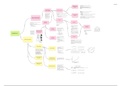
Figure 1 Synergy Between GIS and MCDA
- Identifies the best locations to site something to site something or preserve an area
- For example: housing development, a school, or a corporate headquarters
- Multiple criteria
- In the case of bobcat habitat:
- Slope
- Land use types
- Distance to streams
- Weight criteria relative to one another and combine them to create a suitability map
Spatial Complexity Suitability Modelling
- Multidimensional problem - "Set of techniques and models that are explicitly concerned with spatial patterns and processes"
- Influenced by several criteria (with different - "A distinctive feature of spatial analysis is that its results dependent on the locations or objects (events) and their attributes"
es
importance) - "The results would be different under rearrangements of the spatial distribution of attributes of reconfiguration of the spatial
d
Inclu
- Different decision-makers (with often structure"
conflictual preferences)
Spatial Analysis - From the perspective of decision analysis, we can classify spatial
Introduction to modelling approaches into two categories:
Spatial Complexity - Statistical modelling
- Mathematical modeling
and MCDA
Multi-criteria Decision
Analysis (MCDA)
In
integration in GIS
cl
u de
s
- One of the central elements of GIScience
Confluence of the two research areas:
- The need to expand GIS capabilities for tackling
complex spatial decision problems - System components are mathematically defined
- Improve the performance of decision makers, - Components are related to each other in a series of functional relationships
managers, and citizens when they confront spatial Simulation
Includes
- Results: a mathematical description of a decision process
- A class of SDSS that is based on the concept of integrating GIS and decision problems
Ver
- Model is solved repeatedly, using different parameters and different decision
MCDA
- As these values are changed, a range of solutions are obtained for the problem and the 'best' solution can be chosen from that
sus
- At the most fundamental level, GIS-based MCDA (GIS-MCDA) is a
range
procedure that transforms and combines geographic data (input
maps)
and the decision maker’s (expert or agent) preferences into a decision
(output) map Simulation
“A Spatial Decision Support System (SDSS) can be versus
defined as an interactive, computer- based system - "seek to find the best (optimal) solution to well defined spatial decision or management problems"
designed to support a user or group of users in - Decision/management alternatives (or decision variables) have a geographic (spatial) meaning Optimization
achieving higher effectiveness in decision making
while solving a semi-structured spatial decision
GIS-MCDA methods problem” Optimization Common to all optimization models:
s
rsu
- Quantity (quantities) to be minimized or maximized - Simulation modeling starts with the actions and studies the
effects on the overall system objectives by testing different
Ve
- Quantity is often termed as objective or criterion function
- Set of constraints imposed on the decision variables policies under various external conditions
- Define the set of feasible solutions - Optimization procedures start with a definition of the
- Solution to an optimization problem determines the values of decision variables subject to a set of constraints system objectives and specify the actions that will satisfy those
objectives at the optimum level
- Once the optimum conditions are established, the vicinity
Spatial Decision Minimize or maximize f(x), subject to: x ∈ X of the optimal points is analyzed to determine the effect of
variations in the system
Spatially Explicit
Synergy Between Support Systems
f(x): a criterion (objective) function
MCDA
GIS and MCDA Julia
x: a set of decision variables
X: a set of feasible alternatives
(figure 1)
Julia
Julia If the problem involves a single criterion function: single-criterion (objective) model
"A model is said to be spatially explicit
If more than one criterion function is to be optimized simultaneously: multicriteria (multi-objective) model
when it differentiates behaviors and
predictions according to spatial
location"
MCDA model is considered as
- The primary aim of SDSS is to improve the
Spatial Multi-
effectiveness of decision making by
spatially explicit if:
- Its decision outcomes (ranking or
incorporating decision makers’ knowledge and
Semi-Structured objective
orderings of decision alternatives) are Conventional MCDA Spatial MCDA experience into computer-based procedures
Optimization
not invariant under relocation of the
- Central to the concept of SDSS is the interaction of Decisions
the user(s) with a computer-based system
feasible alternatives
Julia Julia - The ability of a GIS to handle preferences, judgments, Julia
- Decision alternatives in a spatially - Specifically designed for modeling spatial systems and solving
arguments, and opinions involved in the planning
explicit MCDA model be spatial problems such as:
process is very important
geographically defined - Site search problems
Three GIS-MCDA methods: - Common methods in GIS-MCDA - One way of achieving this is to incorporate MCDA
- Such alternatives consists of, at - Location allocation
- Mainly aspatial techniques into the GIS-based procedures
least, two elements: action (what to - Transportation problem
- Conventional MCDA for spatial - Extensions of existing MCDA
do)? and location (where to do it)? - Vehicle routing
decision making methods to analyze spatial
- It contains spatial concepts such as
- Spatially explicit MCDA decision problems
location, distance, contiguity,
- Spatial multi-objective (multicriteria) o Spatial heterogeneity and spatial
connectivity, adjacency, or direction
optimization dependency are not considered
o spatial variability is involved only
implicitly by defining evaluation
criteria based on
the concept of spatial relations such
as proximity, adjacency, and
contiguity
- Provide goods and/or services
- Demand points
- Consume goods and/or services
- Goal of location-allocation: locate the facilities in a way
that supplies the demand points most efficiently
- Twofold problem: simultaneously locates facilities and
allocates the demand points to the facilities
Location-allocation refers to algorithms
used primarily in a GIS to determine an
optimal location for one or more facilities that
will service demand from a given set of points.
Location-Allocation
Figure 1 Synergy Between GIS and MCDA
- Identifies the best locations to site something to site something or preserve an area
- For example: housing development, a school, or a corporate headquarters
- Multiple criteria
- In the case of bobcat habitat:
- Slope
- Land use types
- Distance to streams
- Weight criteria relative to one another and combine them to create a suitability map
Spatial Complexity Suitability Modelling
- Multidimensional problem - "Set of techniques and models that are explicitly concerned with spatial patterns and processes"
- Influenced by several criteria (with different - "A distinctive feature of spatial analysis is that its results dependent on the locations or objects (events) and their attributes"
es
importance) - "The results would be different under rearrangements of the spatial distribution of attributes of reconfiguration of the spatial
d
Inclu
- Different decision-makers (with often structure"
conflictual preferences)
Spatial Analysis - From the perspective of decision analysis, we can classify spatial
Introduction to modelling approaches into two categories:
Spatial Complexity - Statistical modelling
- Mathematical modeling
and MCDA
Multi-criteria Decision
Analysis (MCDA)
In
integration in GIS
cl
u de
s
- One of the central elements of GIScience
Confluence of the two research areas:
- The need to expand GIS capabilities for tackling
complex spatial decision problems - System components are mathematically defined
- Improve the performance of decision makers, - Components are related to each other in a series of functional relationships
managers, and citizens when they confront spatial Simulation
Includes
- Results: a mathematical description of a decision process
- A class of SDSS that is based on the concept of integrating GIS and decision problems
Ver
- Model is solved repeatedly, using different parameters and different decision
MCDA
- As these values are changed, a range of solutions are obtained for the problem and the 'best' solution can be chosen from that
sus
- At the most fundamental level, GIS-based MCDA (GIS-MCDA) is a
range
procedure that transforms and combines geographic data (input
maps)
and the decision maker’s (expert or agent) preferences into a decision
(output) map Simulation
“A Spatial Decision Support System (SDSS) can be versus
defined as an interactive, computer- based system - "seek to find the best (optimal) solution to well defined spatial decision or management problems"
designed to support a user or group of users in - Decision/management alternatives (or decision variables) have a geographic (spatial) meaning Optimization
achieving higher effectiveness in decision making
while solving a semi-structured spatial decision
GIS-MCDA methods problem” Optimization Common to all optimization models:
s
rsu
- Quantity (quantities) to be minimized or maximized - Simulation modeling starts with the actions and studies the
effects on the overall system objectives by testing different
Ve
- Quantity is often termed as objective or criterion function
- Set of constraints imposed on the decision variables policies under various external conditions
- Define the set of feasible solutions - Optimization procedures start with a definition of the
- Solution to an optimization problem determines the values of decision variables subject to a set of constraints system objectives and specify the actions that will satisfy those
objectives at the optimum level
- Once the optimum conditions are established, the vicinity
Spatial Decision Minimize or maximize f(x), subject to: x ∈ X of the optimal points is analyzed to determine the effect of
variations in the system
Spatially Explicit
Synergy Between Support Systems
f(x): a criterion (objective) function
MCDA
GIS and MCDA Julia
x: a set of decision variables
X: a set of feasible alternatives
(figure 1)
Julia
Julia If the problem involves a single criterion function: single-criterion (objective) model
"A model is said to be spatially explicit
If more than one criterion function is to be optimized simultaneously: multicriteria (multi-objective) model
when it differentiates behaviors and
predictions according to spatial
location"
MCDA model is considered as
- The primary aim of SDSS is to improve the
Spatial Multi-
effectiveness of decision making by
spatially explicit if:
- Its decision outcomes (ranking or
incorporating decision makers’ knowledge and
Semi-Structured objective
orderings of decision alternatives) are Conventional MCDA Spatial MCDA experience into computer-based procedures
Optimization
not invariant under relocation of the
- Central to the concept of SDSS is the interaction of Decisions
the user(s) with a computer-based system
feasible alternatives
Julia Julia - The ability of a GIS to handle preferences, judgments, Julia
- Decision alternatives in a spatially - Specifically designed for modeling spatial systems and solving
arguments, and opinions involved in the planning
explicit MCDA model be spatial problems such as:
process is very important
geographically defined - Site search problems
Three GIS-MCDA methods: - Common methods in GIS-MCDA - One way of achieving this is to incorporate MCDA
- Such alternatives consists of, at - Location allocation
- Mainly aspatial techniques into the GIS-based procedures
least, two elements: action (what to - Transportation problem
- Conventional MCDA for spatial - Extensions of existing MCDA
do)? and location (where to do it)? - Vehicle routing
decision making methods to analyze spatial
- It contains spatial concepts such as
- Spatially explicit MCDA decision problems
location, distance, contiguity,
- Spatial multi-objective (multicriteria) o Spatial heterogeneity and spatial
connectivity, adjacency, or direction
optimization dependency are not considered
o spatial variability is involved only
implicitly by defining evaluation
criteria based on
the concept of spatial relations such
as proximity, adjacency, and
contiguity