Hazardous Earth
GEOGRAPHICAL DEBATES
,NOT IN AI
Continental Drift and Plate Tectonics
In the past 20 years, 4.4 billion people (⅔ of the world’s population) have been caught up in natural disasters, causing $2 trillion in
damage (equivalent to the world’s annual aid budget twenty-five times over)
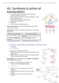
Earth’s interior = concentric structure
3 concentric layers: More research with improved techniques = upper mantle has two layers.
1. Core - inner (solid) 4300 °C, outer (liquid) 3700 °C - Asthenosphere:
made of iron - Layer extends from 100km → 300km
2. Crust - oceanic (younger, more dense), continental - Semi- molten/ viscous and flows slowly
3. Mantle - 1000 °C, made of Fe,Mg, Al, o - Below lithosphere, 180 km thick
- Convection currents exist caused by vast amounts of heat
Core and mantle = separated by a sharp boundary at a depth generated deep in the mantle = semi - molten
of 2900 km asthenosphere flows carrying with it the solid lithosphere
Mantle crust boundary is marked by the Mohorovicic (Moho) and crust
discontinuity - Lithosphere:
Depth below the continents = 35 km - Rigid
Depth under the oceans = 10-15 km - Sandwiched between the crust and asthenosphere
- Varies in thickness and its boundary with the
Thickness Density Mineral asthenosphere is hard to define as it starts to melt and
(kg/m3) composition becomes incorporated
- Lithosphere + crust = oceanic and continental plates
Crust Continental Continental Continental
Mean: 35 km 2.6-2.7 Mainly Continental drift and the theory of plate tectonics
Min: <30 km Oceanic 3.0 granitic, 18th century = maps of the world became more accurate and shapes of
Max: 70 km silicon,
continents and relationships attracted interest
Oceanic: 5-10 aluminium
1801, German geographer Alexander von Humboldt wrote about the fit
km Oceanic
(ballistic, between NE South America and the West Coast of Africa.
silicon & mg) Not until the 20th century that ideas concerning the geographical
positions of the continents received attention
Mantle Depth of 3.3 at Moho Rich in mg
2,900 km 5.6 at core and iron
, NOT IN AI
CONTINENTAL CRUST:
- Thick (10-70 km)
- Buoyant (less dense than oceanic crust)
- Mostly old
- Granitic silica and aluminium SIAL
OCEANIC CRUST:
- Thin (7 km)
- Dense (sinks under continental crust)
- Young
- Basaltic silica and magnesium SIMA
Convergence/ destructive plate boundary
Oceanic crust = heavier therefore subducts =
friction = pressure = heat = melting
, NOT IN AI
CONVECTION CURRENTS EVOLUTION OF PLATE TECTONICS THEORY
- Very slow convection currents flow in this asthenosphere - Mackenzie and Parker - 1967
- Hot magma in the earth moves toward the surface, cools and - Plate tectonics has proven to be as important to the
then sinks again earth sciences as the discovery of atoms to physics and
- Creates convection currents beneath the plates that cause the chemistry
plates to move 4 major scientific developments:
- The movement is caused by thermal convection of the plastic 1. Demonstration of the ruggedness and youth of the
rocks of the atmosphere which drag along the overlying ocean floor
lithospheric plates Collected data (technology had innovated)
Ocean floor was younger than land
Deepest part of the ocean on the edges
2. Confirmation of repeated reversals of the Earth
magnetic field in the geologic past
Iron in rocks = magnetism
When it is liquid the iron naturally rotates to the
polarity of the earth (north and south poles)
When it is solid it becomes fossilised - different
memories of magnetic field prints into the seafloor=
shows the middle of the earth is younger -
paleomagnetism
The next layer of rock went the other direction etc. =
alternating ridges under the ocean where it altered
directions
3. Emergence of the seafloor spreading hypothesis and
associated recycling of oceanic crust
- Slab pull → part of the motion of the tectonic plates caused by 4. Precise documentation that the world's earthquakes
subduction and volcanic activity is concentrated along oceanic
- Ridge push → occurs at mid- ocean ridges due to the trenches and submarine mountain ranges
lithosphere sliding down the hot, raised asthenosphere
GEOGRAPHICAL DEBATES
,NOT IN AI
Continental Drift and Plate Tectonics
In the past 20 years, 4.4 billion people (⅔ of the world’s population) have been caught up in natural disasters, causing $2 trillion in
damage (equivalent to the world’s annual aid budget twenty-five times over)
Earth’s interior = concentric structure
3 concentric layers: More research with improved techniques = upper mantle has two layers.
1. Core - inner (solid) 4300 °C, outer (liquid) 3700 °C - Asthenosphere:
made of iron - Layer extends from 100km → 300km
2. Crust - oceanic (younger, more dense), continental - Semi- molten/ viscous and flows slowly
3. Mantle - 1000 °C, made of Fe,Mg, Al, o - Below lithosphere, 180 km thick
- Convection currents exist caused by vast amounts of heat
Core and mantle = separated by a sharp boundary at a depth generated deep in the mantle = semi - molten
of 2900 km asthenosphere flows carrying with it the solid lithosphere
Mantle crust boundary is marked by the Mohorovicic (Moho) and crust
discontinuity - Lithosphere:
Depth below the continents = 35 km - Rigid
Depth under the oceans = 10-15 km - Sandwiched between the crust and asthenosphere
- Varies in thickness and its boundary with the
Thickness Density Mineral asthenosphere is hard to define as it starts to melt and
(kg/m3) composition becomes incorporated
- Lithosphere + crust = oceanic and continental plates
Crust Continental Continental Continental
Mean: 35 km 2.6-2.7 Mainly Continental drift and the theory of plate tectonics
Min: <30 km Oceanic 3.0 granitic, 18th century = maps of the world became more accurate and shapes of
Max: 70 km silicon,
continents and relationships attracted interest
Oceanic: 5-10 aluminium
1801, German geographer Alexander von Humboldt wrote about the fit
km Oceanic
(ballistic, between NE South America and the West Coast of Africa.
silicon & mg) Not until the 20th century that ideas concerning the geographical
positions of the continents received attention
Mantle Depth of 3.3 at Moho Rich in mg
2,900 km 5.6 at core and iron
, NOT IN AI
CONTINENTAL CRUST:
- Thick (10-70 km)
- Buoyant (less dense than oceanic crust)
- Mostly old
- Granitic silica and aluminium SIAL
OCEANIC CRUST:
- Thin (7 km)
- Dense (sinks under continental crust)
- Young
- Basaltic silica and magnesium SIMA
Convergence/ destructive plate boundary
Oceanic crust = heavier therefore subducts =
friction = pressure = heat = melting
, NOT IN AI
CONVECTION CURRENTS EVOLUTION OF PLATE TECTONICS THEORY
- Very slow convection currents flow in this asthenosphere - Mackenzie and Parker - 1967
- Hot magma in the earth moves toward the surface, cools and - Plate tectonics has proven to be as important to the
then sinks again earth sciences as the discovery of atoms to physics and
- Creates convection currents beneath the plates that cause the chemistry
plates to move 4 major scientific developments:
- The movement is caused by thermal convection of the plastic 1. Demonstration of the ruggedness and youth of the
rocks of the atmosphere which drag along the overlying ocean floor
lithospheric plates Collected data (technology had innovated)
Ocean floor was younger than land
Deepest part of the ocean on the edges
2. Confirmation of repeated reversals of the Earth
magnetic field in the geologic past
Iron in rocks = magnetism
When it is liquid the iron naturally rotates to the
polarity of the earth (north and south poles)
When it is solid it becomes fossilised - different
memories of magnetic field prints into the seafloor=
shows the middle of the earth is younger -
paleomagnetism
The next layer of rock went the other direction etc. =
alternating ridges under the ocean where it altered
directions
3. Emergence of the seafloor spreading hypothesis and
associated recycling of oceanic crust
- Slab pull → part of the motion of the tectonic plates caused by 4. Precise documentation that the world's earthquakes
subduction and volcanic activity is concentrated along oceanic
- Ridge push → occurs at mid- ocean ridges due to the trenches and submarine mountain ranges
lithosphere sliding down the hot, raised asthenosphere