ATPL (A)
Review Worksheets
061 GENERAL NAVIGATION
BY KDMN
2020
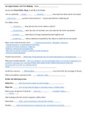
, I/ THE EARTH
01 SHAPE OF THE EARTH
• Considered as being a sphere, flattened at its poles.
• For navigation purpose, mathematically represented by ellipsoid WGS 84 model (World Geodic System 84).
• Rotation: 360°/day, compression ratio = 0.3%, circumference = 40 000 km
• Earth’s axis is 23°6’ tilted.
02 GREAT CIRCLE = ORTHODROMIC LINE
• Shortest distance between 2 points on the surface of the sphere. It cuts the earth in 2 equals parts
• The great circle vertex is the point with the greatest latitude.
• Meridian, equator, other:
03 SMALL CIRCLE
• All the other types of circles
04 GEOCENTRIC & GEOGRAPHIC/GEODETIC LATITUDE
•Difference max at LAT= 45°
Review Worksheets
061 GENERAL NAVIGATION
BY KDMN
2020
, I/ THE EARTH
01 SHAPE OF THE EARTH
• Considered as being a sphere, flattened at its poles.
• For navigation purpose, mathematically represented by ellipsoid WGS 84 model (World Geodic System 84).
• Rotation: 360°/day, compression ratio = 0.3%, circumference = 40 000 km
• Earth’s axis is 23°6’ tilted.
02 GREAT CIRCLE = ORTHODROMIC LINE
• Shortest distance between 2 points on the surface of the sphere. It cuts the earth in 2 equals parts
• The great circle vertex is the point with the greatest latitude.
• Meridian, equator, other:
03 SMALL CIRCLE
• All the other types of circles
04 GEOCENTRIC & GEOGRAPHIC/GEODETIC LATITUDE
•Difference max at LAT= 45°