Science Olympiad - Dynamic Planet Exam Study Guide
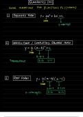
Science Olympiad - Dynamic Planet Exam Study Guide USGS topographic maps - answerdetailed record of a land area, giving geographic positions and elevations for both natural and man-made features. They show the shape of the land the mountains, valleys, and plains by means of brown contour lines stream order - answerThe concept that describes the hierarchy of stream types (see image) Perennial streams - answerWater flows in the stream at least 90 percent of the time in a well defined channel. Intermittent streams - answerFlow generally occurs only during the wet season (50 percent of the time or less). Ephemeral streams - answerFlow generally occurs for a short time after extreme storms. The channel is usually not well defined. drainage patterns - answerPatterns in which water drains: dendritic (dentrites), trellis (like in farming), rectangular (like those sand shaking things), and radial (run down the mountain). (See and review image) Main channel - answerthe largest channel into which smaller streams flow. Tributaries - answersmall river or stream that flows in to a larger river or stream; a branch of the river Watershed - answera land area that channels rainfall and snowmelt to creeks, streams, and rivers, and eventually to outflow points braided channel - answerA channel that is divided into smaller channels by temporary islands called eyots. These channels tend to form in rivers that have a significant amount of sedimentary load. meandering channel - answera single channel that winds snakelike over the area it covers Straight channel - answerA channel that flows in a relatively straight path; these often develop along the lines of faults and master joints. Calculations of sinuosity - answerThe length of the stream/channel divided by the distance between the beginning and end point of that stream/channel +The greater the number, the more tortuous (strongly meandering) the path the river takes. +this calculates the curvature of the body. Weathering - answerthe breaking down of rocks, soils and minerals through contact with water, atmospheric gases, and/or biological organisms. Erosion - answerthe geological process in which earthen materials are worn away and transported by natural forces such as wind or water. This creates sediment Clasts - answerFragments of rocks or minerals ranging in size Very Fine Clast: Clay/Mud - answerClasts that are less than 0.0039mm in size Fine Clast: Silt/Mud - answerClasts that are 0.0039mm - 0.0625mm in size Medium Clast: Sand - answerClasts that are 0.0625mm - 2.0mm in size Coarse Clast: Gravel/Pebbles - answerClasts that are greater than 2.0mm in size Transportation of sediment - answerthe movement of organic and inorganic particles by water, gravity, wind, ice, etc. (Sediment) Capacity - answerthe maximum load of sediment that a given body of water, ice, wind, etc. can carry/transport (Sediment) Competence - answerthe maximum size of the pieces of sediment that a given body of water, ice, wind, etc. can carry/transport. (Sediment) Deposition - answerwhen the amount of sediment becomes greater than the carrying capacity of the force that is moving it; sediment from eroded materials settles. geology - answerthe science that deals with the earth's physical structure and substance, its history, and the processes that act on it. Gradient - answer(Slope) the change in elevation between the two points found on your topographic map divided by their horizontal distance. +high gradient = rapid flow of water +change in x over change in y but in topo map terms base level - answerThe lowest level to which a stream can erode or running water can flow (the part of the slide where a kid starts to slow down - the flattened bottom) Floodplain - answerthe flat, wide area of land along a river; an area that is subject to natural flooding from an adjoining waterway
Written for
- Institution
- Science Olympiad
- Course
- Science Olympiad
Document information
- Uploaded on
- June 7, 2024
- Number of pages
- 10
- Written in
- 2023/2024
- Type
- Exam (elaborations)
- Contains
- Questions & answers
Subjects
-
science olympiad dynamic planet exam study guide
Also available in package deal