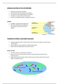
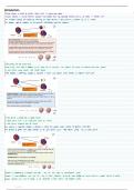
MID-LATITUDE CYCLONES
A low pressure system that develops in the westerlies and moves from west to
east
Moist, warm air from the subtropics meets the dry, cold air from the poles
along the polar front
General characteristics:
1. Form at the Polar front due to the large temperature distance
between the cold polar & warm subtropical air
(between 40° & 60° north and south)
2. Carried by westerly winds
3. Consists of a warm & cold front (does not have an ‘eye’)
4. Air pressure at the centre = 996hPa
5. Diameter = between 1500-3000km
6. Usually occur in ‘families’ - lots of systems form one after the other
& travel together
7. Travel at about 60kph
8. Last between 4-14 days
9. Responsible for most winter storms within the middle latitudes
[the ITCZ shifts north during winter (winter solstice) which then causes the
LP systems to shift north with it causing winter rainfall]
[In summer, the ITCZ shifts south and the MLC’s are usually too far to
affect South Africa]
, Conditions necessary for the formation of MLC’s:
A mass of warm air meeting a mass of cold air
Upper air divergence so that more air can rise
A disturbance in the upper air winds to trigger the formation
CROSS-SECTION OF A MID-LATITUDE CYCLONE
FRONTS
Warm fronts are much shorter than cold fronts, meaning that often a
location won’t experience both fronts but rather one or the other
WARM FRONT COLD FRONT
CLOUDS Cirrus, altostratus & Tall cumulonimbus clouds
nimbostratus clouds
AIR Gentle pressure gradient Steep pressure gradient
Air rises relatively slowly Rising of air is rapid
RAINFALL Gentle steady rain & Thunderstorms & heavy rain
sometimes none ahead & behind the front