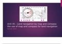
Unit 35 – Land navigation by map and compass
the use of map and compass for land navigation
RACHEL ROUT
, M1 – explain grid references on maps
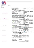
Eastings-
Eastings are lines which 4 Figure Grid References –
run up and down the A 4 figure grid reference is often used to
map, you can use them get a rough idea of the area/ checkpoint
to measure how far to that you are at or are heading to. To find
travel east. any grid reference you always go ‘along
the corridor and up the stairs’.
Northings –
Northings are lines 6 Figure Grid References –
which run across the A six figure grid reference will give you
map horizontally. You the exact point in that square that you
are heading towards. The square can be
can use them to
broken into 10 small lines across and 10
measure how far to lines up. This is put at the end of the 4
travel north. figure grid reference to give you an exact
location.
the use of map and compass for land navigation
RACHEL ROUT
, M1 – explain grid references on maps
Eastings-
Eastings are lines which 4 Figure Grid References –
run up and down the A 4 figure grid reference is often used to
map, you can use them get a rough idea of the area/ checkpoint
to measure how far to that you are at or are heading to. To find
travel east. any grid reference you always go ‘along
the corridor and up the stairs’.
Northings –
Northings are lines 6 Figure Grid References –
which run across the A six figure grid reference will give you
map horizontally. You the exact point in that square that you
are heading towards. The square can be
can use them to
broken into 10 small lines across and 10
measure how far to lines up. This is put at the end of the 4
travel north. figure grid reference to give you an exact
location.