

Indian Ocean Tsunami, 2004
Date: 26th December 2004
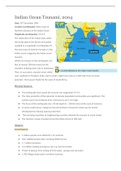
Location (earthquake): West Coast of
Northern Sumatra in the Indian Ocean
Magnitude (earthquake): 9.0-9.3
The subduction of the Indian plate under
the Sunda plate & the Burma microplate
resulted in a magnitude 9 earthquake off
the west coast of northern Sumatra in the
indian ocean, triggering the Indian ocean
tsunami.
Within 20 minutes of the earthquake, the
first of several 100-foot waves hit the
shoreline of Banda Aceh (city in Indonesia).
Then, in succession, tsunami waves rolled
over coastlines in Thailand, India, and Sri Lanka . Eight hours later & 5,000 miles from its Asian
epicenter, the tsunami finally hit the coast of South Africa.
Physical features:
● The earthquake that caused the tsunami was magnitude 9.0-9.3
● The close proximity of the epicenter to densely populated communities was significant. The
earliest waves struck Banda Ache, Indonesia & were 17m high.
● The focus of the earthquake was ~30 km depth & ~ 200 km west of the coast of Sumatra.
● In some coastal areas, mangrove forests had been removed to make way for tourist
developments reducing natural protection.
● The low-lying coastlines of neighbouring countries allowed the tsunami to travel inland.
● The tsunami’s waves traveled across the Indian Ocean at 500 mph.
Impacts:
Social impacts:
● 5 million people were affected in 14 countries
● Over 230000 people died, including 9000 tourists.
● 1.7 million homeless.
● 5-6 million needing emergency aid, e.g. food and water.
● Threat of disease from mixing of fresh water, sewage and salt water.
● 1,500 villages destroyed in northern Sumatra.
Date: 26th December 2004
Location (earthquake): West Coast of
Northern Sumatra in the Indian Ocean
Magnitude (earthquake): 9.0-9.3
The subduction of the Indian plate under
the Sunda plate & the Burma microplate
resulted in a magnitude 9 earthquake off
the west coast of northern Sumatra in the
indian ocean, triggering the Indian ocean
tsunami.
Within 20 minutes of the earthquake, the
first of several 100-foot waves hit the
shoreline of Banda Aceh (city in Indonesia).
Then, in succession, tsunami waves rolled
over coastlines in Thailand, India, and Sri Lanka . Eight hours later & 5,000 miles from its Asian
epicenter, the tsunami finally hit the coast of South Africa.
Physical features:
● The earthquake that caused the tsunami was magnitude 9.0-9.3
● The close proximity of the epicenter to densely populated communities was significant. The
earliest waves struck Banda Ache, Indonesia & were 17m high.
● The focus of the earthquake was ~30 km depth & ~ 200 km west of the coast of Sumatra.
● In some coastal areas, mangrove forests had been removed to make way for tourist
developments reducing natural protection.
● The low-lying coastlines of neighbouring countries allowed the tsunami to travel inland.
● The tsunami’s waves traveled across the Indian Ocean at 500 mph.
Impacts:
Social impacts:
● 5 million people were affected in 14 countries
● Over 230000 people died, including 9000 tourists.
● 1.7 million homeless.
● 5-6 million needing emergency aid, e.g. food and water.
● Threat of disease from mixing of fresh water, sewage and salt water.
● 1,500 villages destroyed in northern Sumatra.


