Kenocia Fernandes 244890
Unit 29 P3
Dilip Desai
AVIATION METEOROLOGY FOR GROUND
STAFF
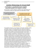
P3 Interpret synoptic weather charts and aviation
weather reports produced by the Met Office.
What is a synoptic chart?
The term 'synoptic' apparently means an overview of the
present circumstance. This indicates the pressure pattern,
fronts, wind direction and intensity in weather terms, and
how they will shift and develop over the next few days. In
order to maintain this balance, temperature, pressure, and
winds are all in balance and the atmosphere is constantly
changing which is why the United Kingdom sees
such a changing climate. The letter
L indicates
Isoba Low
rs pressure
Occluded
, Kenocia Fernandes 244890
Unit 29 P3
Dilip Desai
What do the symbols on the chart above symbolise:
Isobars
Isobars, which join areas of the same barometric pressure,
are the circular lines you see on the diagram. The pattern of
pressure is important because we can use it to tell us where
the wind comes from and how strong it is. It also displays
high- and low-pressure zones. In terms of the wind direction,
air travels in the clockwise direction around high pressure
and in the anticlockwise direction around low pressure, so
isobars also tell us the wind direction and velocity. If the
difference between high- and low-pressure areas is larger,
then we have a wide gradient and to try to manage this
difference, the air will move faster. This is seen on a synoptic
graph with isobars that are very close together and, as a
result, we experience strong winds.
Fronts
Also on a synoptic chart are the lines, triangles and semi-
circles representing 'fronts'. There are various kinds of air
masses moving around the world as the atmosphere needs to
control temperature, pressure, and wind. The variations are
mainly between how wet, cold, dry, and humid the air is, and
the boundary between these different air types is simply
marked by fronts.
Warm and Cold front- The boundary line where a warm
air mass replaces a cold air mass is known as a warm
front. A warm front is shown with a red line and red
semi-circles. A cold weather front is the transition zone
where a cold air mass replaces a warmer air mass. A
Unit 29 P3
Dilip Desai
AVIATION METEOROLOGY FOR GROUND
STAFF
P3 Interpret synoptic weather charts and aviation
weather reports produced by the Met Office.
What is a synoptic chart?
The term 'synoptic' apparently means an overview of the
present circumstance. This indicates the pressure pattern,
fronts, wind direction and intensity in weather terms, and
how they will shift and develop over the next few days. In
order to maintain this balance, temperature, pressure, and
winds are all in balance and the atmosphere is constantly
changing which is why the United Kingdom sees
such a changing climate. The letter
L indicates
Isoba Low
rs pressure
Occluded
, Kenocia Fernandes 244890
Unit 29 P3
Dilip Desai
What do the symbols on the chart above symbolise:
Isobars
Isobars, which join areas of the same barometric pressure,
are the circular lines you see on the diagram. The pattern of
pressure is important because we can use it to tell us where
the wind comes from and how strong it is. It also displays
high- and low-pressure zones. In terms of the wind direction,
air travels in the clockwise direction around high pressure
and in the anticlockwise direction around low pressure, so
isobars also tell us the wind direction and velocity. If the
difference between high- and low-pressure areas is larger,
then we have a wide gradient and to try to manage this
difference, the air will move faster. This is seen on a synoptic
graph with isobars that are very close together and, as a
result, we experience strong winds.
Fronts
Also on a synoptic chart are the lines, triangles and semi-
circles representing 'fronts'. There are various kinds of air
masses moving around the world as the atmosphere needs to
control temperature, pressure, and wind. The variations are
mainly between how wet, cold, dry, and humid the air is, and
the boundary between these different air types is simply
marked by fronts.
Warm and Cold front- The boundary line where a warm
air mass replaces a cold air mass is known as a warm
front. A warm front is shown with a red line and red
semi-circles. A cold weather front is the transition zone
where a cold air mass replaces a warmer air mass. A

