

Chapter 4.1: UK’s physical landscape
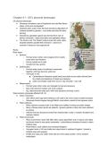
UK physical landscape
● Grampian mountains: part of Highlands and has Ben Nevis -
steep, rocky and unpopulated
● Cheshire plain: area of low, flat land formed by deposition of
material eroded by glaciers - very fertile and used for dairy
farming
● Snowdonia: glaciated upland area formed from rock of
extinct volcanoes - steep mountains and glaciated valleys
● The Downs and The Weald: lowland area with wide valley
situated between parallel hills of Downs - used to be
covered in forest but now agricultural
Rocks
Rock types:
● Igneous:
○ Formed when molten rock (magma) from mantle
cools down and hardens
○ Forms crystals as it cools
○ Usually hard eg. granite
● Sedimentary:
○ Formed when layers of sediment compacted
together until they become solid rock
○ Two types in UK:
■ Carboniferous limestone (quite hard) and chalk (much softer) formed from
tiny shells and skeletons of dead sea creatures
■ Clays and shales made from mud or clay minerals - very soft
● Metamorphic:
○ Formed when other rocks are changed by heat and pressure
○ New rocks become harder and more compact
○ Eg. shale becomes slate and, with more pressure and heat, schist
Ways tectonic processes affected UK: (3)
● Active volcanoes:
○ 520 million years ago land making up UK used to be much closer to plate boundary
○ Volcanoes forced magma through Earth’s crust which cooled to form igneous rocks
● Plate collisions:
○ Plate collisions caused rocks to be folded and uplifted, forming mountain ranges
○ Many of these areas remain as uplands - igneous granite is hard and more resistant
to erosion
○ Intense heat and pressure formed hard metamorphic rocks in northern Scotland and
northern Ireland
● Plate movements:
○ Plate movements meant 345-280 million years ago Britain was in tropics and higher
sea levels meant it was partly underwater - carboniferous limestone formed in warm
shallow seas
○ Peak District, south Wales and southwest England
○ Youngest rocks in UK are chalks and clays found in southern England - formed in
shallow seas and swamps
○ Chalks and clays are softer rocks that are more easily eroded - forms lowland
landscapes
,Rock characteristics (4)
● Granite:
○ Very resistant and forms upland landscapes
○ Has lots of unevenly spread cracks - where rock wears down faster
○ Areas with fewer joints weathered more slowly than surrounding rock and stick out at
surface, forming tors
○ Granite is impermeable (doesn’t let water through) - creates moorlands (large areas
of waterlogged land and acidic soil with low-growing vegetation)
● Slate and schist:
○ Slate forms in layers creating weak planes in rock
○ Generally very hard and resistant to weathering but easily split into thin slabs
○ Schist has bigger crystals and splits easily into small flakes
○ Slate and schist form rugged, upland landscapes
○ Impermeable - forms acidic and waterlogged soils
● Carboniferous limestone:
○ Rainwater slowly eats away at limestone through carbonation weathering
○ Most weathering happens along joints in rock, creating features eg. pavements (flat
areas with deep weathered cracks)
○ Limestone is permeable so limestone areas have dry valleys and resurgent rivers
(rivers that pop out at surface when limestone is on top of impermeable rock)
● Chalk and clay:
○ Chalk harder than clay - forms escarpments (hills) in lowlands and cliffs at coast
○ One side of hill is usually steep and other side is more gentle
○ Chalk is permeable - water flows through it and emerges as spring where it meets
impermeable rock
○ Clay is very soft and easily eroded - forms wide flat valleys in UK lowlands
○ Impermeable so water flows over surface
Glacial ice
● Has been lots of glacial periods during last 2.6 million years
● During glacial periods, parts of UK were covered in large ice sheet
● At its peak, ice covered most of Scotland, Ireland and Wales and
came up to Bristol Channel
● Ice very powerful so able to erode landscape - carved out u-shaped
valleys in upland areas
● Deposited lots of material when melted
Physical landscape processes
Physical processes
● Physical processes are constantly changing landscape of UK
● Weathering: breakdown of rock into smaller pieces - mechanical, chemical or biological
● Erosion: wears away rock - ice eroded landscape, rivers and sea constantly erode landscape
● Post-glacial river processes: melting ice at end of glacial periods - made rivers much bigger
than normal with more power to erode and left distinctive landforms when melted
● Slope processes - including mass movements eg. landslides
● Physical processes affected by climate eg. col climate increases chance of freeze-thaw
Distinctive upland landscapes
● Snowdonia: upland landscape - map
shows tightly packed contours and lots of
rocky crags
, Distinctive lowland landscapes
● The Downs and The Weald: lowland
landscape - chalk escarpments (The
Downs) lie either side of a large flat areas
of clay (The Weald)
● Valley is flat (contour lines on map are
widely spaced)
Human landscape processes (3)
Agriculture
● People have cleared land of forest to make space for farming
● Over time hedgerows and walls have been put in to mark fields
● Different landscapes suitable for different types of farming:
○ Flat land with good soil eg. East England suitable for arable farming (growing crops)
○ Warm and wet areas eg. Southwest England good for dairy farming - lots of large,
grassy fields
○ Sheep farming in harsher conditions in uplands - caused lack of trees in hills
● OS maps show influence of agriculture, including field boundaries and drainage ditches
Forestry
● Management of areas of woodland - can be used for timber, recreation or conservation
● UK used to be covered in deciduous woodland but very little natural woodland left
● Coniferous (evergreen) forests planted for timber - often planted in straight lines (unnatural)
and landscape is left bare when areas felled
● In some places, deciduous woodland is replanted to try and return area to natural state
● OS maps show forestry plantations and areas being managed
Settlement
● Lots of factors influence where settlements have developed eg. water availability
● Other factors such as bridging points over rivers and availability of resources played a part
● As settlements grew they further influenced landscape eg. :
○ Land concreted over for roads and buildings, affecting drainage patterns
○ Some rivers diverted through underground channels
○ Some river channels straightened or had embankments built to prevent flooding
● Most of biggest cities are ports and industrial areas - more urban than natural
● OS maps show buildings, railways, canals and embankments
Chapter 4.2: Coastal change and conflict
Coastal weathering and erosion
Weathering (3)
● Mechanical weathering:
○ Breakdown of rock without changing chemical composition
○ Salt weathering:
■ Seawater gets into cracks in rock
■ When water evaporates, salt crystals form. As they form they expand, putting
pressure on rock
■ Repeated evaporation of saltwater and forming of salt crystals widens cracks
and causes rock to break up
● Chemical weathering:
○ Breakdown of rock by changing its chemical composition
○ Carbonation weathering: happens in warm and wet conditions:
UK physical landscape
● Grampian mountains: part of Highlands and has Ben Nevis -
steep, rocky and unpopulated
● Cheshire plain: area of low, flat land formed by deposition of
material eroded by glaciers - very fertile and used for dairy
farming
● Snowdonia: glaciated upland area formed from rock of
extinct volcanoes - steep mountains and glaciated valleys
● The Downs and The Weald: lowland area with wide valley
situated between parallel hills of Downs - used to be
covered in forest but now agricultural
Rocks
Rock types:
● Igneous:
○ Formed when molten rock (magma) from mantle
cools down and hardens
○ Forms crystals as it cools
○ Usually hard eg. granite
● Sedimentary:
○ Formed when layers of sediment compacted
together until they become solid rock
○ Two types in UK:
■ Carboniferous limestone (quite hard) and chalk (much softer) formed from
tiny shells and skeletons of dead sea creatures
■ Clays and shales made from mud or clay minerals - very soft
● Metamorphic:
○ Formed when other rocks are changed by heat and pressure
○ New rocks become harder and more compact
○ Eg. shale becomes slate and, with more pressure and heat, schist
Ways tectonic processes affected UK: (3)
● Active volcanoes:
○ 520 million years ago land making up UK used to be much closer to plate boundary
○ Volcanoes forced magma through Earth’s crust which cooled to form igneous rocks
● Plate collisions:
○ Plate collisions caused rocks to be folded and uplifted, forming mountain ranges
○ Many of these areas remain as uplands - igneous granite is hard and more resistant
to erosion
○ Intense heat and pressure formed hard metamorphic rocks in northern Scotland and
northern Ireland
● Plate movements:
○ Plate movements meant 345-280 million years ago Britain was in tropics and higher
sea levels meant it was partly underwater - carboniferous limestone formed in warm
shallow seas
○ Peak District, south Wales and southwest England
○ Youngest rocks in UK are chalks and clays found in southern England - formed in
shallow seas and swamps
○ Chalks and clays are softer rocks that are more easily eroded - forms lowland
landscapes
,Rock characteristics (4)
● Granite:
○ Very resistant and forms upland landscapes
○ Has lots of unevenly spread cracks - where rock wears down faster
○ Areas with fewer joints weathered more slowly than surrounding rock and stick out at
surface, forming tors
○ Granite is impermeable (doesn’t let water through) - creates moorlands (large areas
of waterlogged land and acidic soil with low-growing vegetation)
● Slate and schist:
○ Slate forms in layers creating weak planes in rock
○ Generally very hard and resistant to weathering but easily split into thin slabs
○ Schist has bigger crystals and splits easily into small flakes
○ Slate and schist form rugged, upland landscapes
○ Impermeable - forms acidic and waterlogged soils
● Carboniferous limestone:
○ Rainwater slowly eats away at limestone through carbonation weathering
○ Most weathering happens along joints in rock, creating features eg. pavements (flat
areas with deep weathered cracks)
○ Limestone is permeable so limestone areas have dry valleys and resurgent rivers
(rivers that pop out at surface when limestone is on top of impermeable rock)
● Chalk and clay:
○ Chalk harder than clay - forms escarpments (hills) in lowlands and cliffs at coast
○ One side of hill is usually steep and other side is more gentle
○ Chalk is permeable - water flows through it and emerges as spring where it meets
impermeable rock
○ Clay is very soft and easily eroded - forms wide flat valleys in UK lowlands
○ Impermeable so water flows over surface
Glacial ice
● Has been lots of glacial periods during last 2.6 million years
● During glacial periods, parts of UK were covered in large ice sheet
● At its peak, ice covered most of Scotland, Ireland and Wales and
came up to Bristol Channel
● Ice very powerful so able to erode landscape - carved out u-shaped
valleys in upland areas
● Deposited lots of material when melted
Physical landscape processes
Physical processes
● Physical processes are constantly changing landscape of UK
● Weathering: breakdown of rock into smaller pieces - mechanical, chemical or biological
● Erosion: wears away rock - ice eroded landscape, rivers and sea constantly erode landscape
● Post-glacial river processes: melting ice at end of glacial periods - made rivers much bigger
than normal with more power to erode and left distinctive landforms when melted
● Slope processes - including mass movements eg. landslides
● Physical processes affected by climate eg. col climate increases chance of freeze-thaw
Distinctive upland landscapes
● Snowdonia: upland landscape - map
shows tightly packed contours and lots of
rocky crags
, Distinctive lowland landscapes
● The Downs and The Weald: lowland
landscape - chalk escarpments (The
Downs) lie either side of a large flat areas
of clay (The Weald)
● Valley is flat (contour lines on map are
widely spaced)
Human landscape processes (3)
Agriculture
● People have cleared land of forest to make space for farming
● Over time hedgerows and walls have been put in to mark fields
● Different landscapes suitable for different types of farming:
○ Flat land with good soil eg. East England suitable for arable farming (growing crops)
○ Warm and wet areas eg. Southwest England good for dairy farming - lots of large,
grassy fields
○ Sheep farming in harsher conditions in uplands - caused lack of trees in hills
● OS maps show influence of agriculture, including field boundaries and drainage ditches
Forestry
● Management of areas of woodland - can be used for timber, recreation or conservation
● UK used to be covered in deciduous woodland but very little natural woodland left
● Coniferous (evergreen) forests planted for timber - often planted in straight lines (unnatural)
and landscape is left bare when areas felled
● In some places, deciduous woodland is replanted to try and return area to natural state
● OS maps show forestry plantations and areas being managed
Settlement
● Lots of factors influence where settlements have developed eg. water availability
● Other factors such as bridging points over rivers and availability of resources played a part
● As settlements grew they further influenced landscape eg. :
○ Land concreted over for roads and buildings, affecting drainage patterns
○ Some rivers diverted through underground channels
○ Some river channels straightened or had embankments built to prevent flooding
● Most of biggest cities are ports and industrial areas - more urban than natural
● OS maps show buildings, railways, canals and embankments
Chapter 4.2: Coastal change and conflict
Coastal weathering and erosion
Weathering (3)
● Mechanical weathering:
○ Breakdown of rock without changing chemical composition
○ Salt weathering:
■ Seawater gets into cracks in rock
■ When water evaporates, salt crystals form. As they form they expand, putting
pressure on rock
■ Repeated evaporation of saltwater and forming of salt crystals widens cracks
and causes rock to break up
● Chemical weathering:
○ Breakdown of rock by changing its chemical composition
○ Carbonation weathering: happens in warm and wet conditions:


