

The Coast and Littoral zone
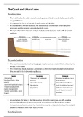
The Littoral Zone
This is defined as the wider coastal including adjacent land areas & shallow parts of the
sea just offshore.
It is exposed to the air at low tide & underwater at high tide.
It is divided into different sections. The backshore & foreshore are where physical
processes and the greatest amount of activity occur.
The type of coastline may vary and can include: sandy beaches, rocky cliffs & coastal
wetlands.
Nearshore
Usually above the Intertidal zone Breaker zone Beyond the influence
influence of the water. of waves
The coastal system
The coast is constantly moving/changing & may be seen as a system that is driven by the
energy of the waves.
The system has inputs, outputs & processes & when the inputs & outputs are balanced
they are said to be in dynamic equilibrium.
Inputs Processes Outputs
-Atmospheric -Transport (of sediment) -Erosional landforms (arch,
(weather/climate, solar -Erosion stack, stump)
energy) -Mass Movement -Depositional landforms
-Land (rock type & structure). -Weathering (spits, tombolos, beaches)
-People (human activity,
-Deposition -Different types of coast
coastal management)
(sandy beaches, coastal
-Marine (waves, tides, storm
wetlands)
Surges)
An example is The Wash & Norfolk beaches where the main input are cliffs eroding
between West Runton & Weytome as well as in Holderness. This sediment is then
transported southwards along the Lincolnshire coast & is deposited on beaches (output).
Sediment may also come from tidal currents.
Classifying Coasts
, Coasts may be classified based on geology, energy, the balance between deposition &
erosion & sea level.
However, no classification is definitive for example Cornwall is a high energy coastline
which is mainly rocky but also has long stretches of sand.
Factors affecting Coasts
Terrestrial
Rock type of the coast will make a significant difference for example; soft rock erodes
faster than hard.
Deltas form where rivers meet the sea which will alter the shape of coasts.
Composition of rock layers will affect their shape.
Tectonics may affect coasts. Earthquakes can move rock & cause tsunamis which can
destroy coastlines.
Mangroves/coral reefs can alter the shape as they slow incoming waves.
Human
Ports, docks & transport can be constructed altering the shape. Boats may als9o destroy
coral reefs, increasing erosion.
Coasts can be used for recreation & tourism. Increased foot traffic.
Humans may settle on coastlines.
Global warming is altering their shape due to rising sea temperatures.
Atmospheric
Certain types of weather may affect coasts. E.g. high winds & heavy rain.
The moon affects the tide which can alter the shape of coasts.
Temperatures may also later their shape.
Marine
Biotic creatures such as coral may alter coastal shape.
Waves, tide & salt spray may also alter their shape.
High/low energy coastlines
High energy coastlines have more powerful waves & so the rate of erosion is higher than
the rate of deposition. Examples include Cornwall & North-West Scotland due to them
being Atlantic-facing.
Landforms such as headlands, cliffs may be found at high energy coastlines.
Low Energy coastlines have less powerful waves & so the rate of deposition is higher
than the rate of erosion. An example is the Northumberland Coastline.
Depositional landforms such as spits & beaches may be found here.
The Littoral Zone
This is defined as the wider coastal including adjacent land areas & shallow parts of the
sea just offshore.
It is exposed to the air at low tide & underwater at high tide.
It is divided into different sections. The backshore & foreshore are where physical
processes and the greatest amount of activity occur.
The type of coastline may vary and can include: sandy beaches, rocky cliffs & coastal
wetlands.
Nearshore
Usually above the Intertidal zone Breaker zone Beyond the influence
influence of the water. of waves
The coastal system
The coast is constantly moving/changing & may be seen as a system that is driven by the
energy of the waves.
The system has inputs, outputs & processes & when the inputs & outputs are balanced
they are said to be in dynamic equilibrium.
Inputs Processes Outputs
-Atmospheric -Transport (of sediment) -Erosional landforms (arch,
(weather/climate, solar -Erosion stack, stump)
energy) -Mass Movement -Depositional landforms
-Land (rock type & structure). -Weathering (spits, tombolos, beaches)
-People (human activity,
-Deposition -Different types of coast
coastal management)
(sandy beaches, coastal
-Marine (waves, tides, storm
wetlands)
Surges)
An example is The Wash & Norfolk beaches where the main input are cliffs eroding
between West Runton & Weytome as well as in Holderness. This sediment is then
transported southwards along the Lincolnshire coast & is deposited on beaches (output).
Sediment may also come from tidal currents.
Classifying Coasts
, Coasts may be classified based on geology, energy, the balance between deposition &
erosion & sea level.
However, no classification is definitive for example Cornwall is a high energy coastline
which is mainly rocky but also has long stretches of sand.
Factors affecting Coasts
Terrestrial
Rock type of the coast will make a significant difference for example; soft rock erodes
faster than hard.
Deltas form where rivers meet the sea which will alter the shape of coasts.
Composition of rock layers will affect their shape.
Tectonics may affect coasts. Earthquakes can move rock & cause tsunamis which can
destroy coastlines.
Mangroves/coral reefs can alter the shape as they slow incoming waves.
Human
Ports, docks & transport can be constructed altering the shape. Boats may als9o destroy
coral reefs, increasing erosion.
Coasts can be used for recreation & tourism. Increased foot traffic.
Humans may settle on coastlines.
Global warming is altering their shape due to rising sea temperatures.
Atmospheric
Certain types of weather may affect coasts. E.g. high winds & heavy rain.
The moon affects the tide which can alter the shape of coasts.
Temperatures may also later their shape.
Marine
Biotic creatures such as coral may alter coastal shape.
Waves, tide & salt spray may also alter their shape.
High/low energy coastlines
High energy coastlines have more powerful waves & so the rate of erosion is higher than
the rate of deposition. Examples include Cornwall & North-West Scotland due to them
being Atlantic-facing.
Landforms such as headlands, cliffs may be found at high energy coastlines.
Low Energy coastlines have less powerful waves & so the rate of deposition is higher
than the rate of erosion. An example is the Northumberland Coastline.
Depositional landforms such as spits & beaches may be found here.


