AP HUMAN GEOGRAPHY
UNIT 1 VOCABULARY
Thinking Geographically
29 essential terms, organized by topic and aligned to the official College Board framework.
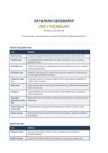
Maps & Geographic Data
Term Definition
Reference map A map showing general locational information such as roads, borders, and cities.
Thematic map A map displaying the spatial pattern of a specific data theme, such as income or
population density.
Choropleth map A thematic map using color shading intensity across predefined areas (e.g., counties)
to represent data values.
Dot density map A thematic map using dots to represent the presence or quantity of a phenomenon,
showing spatial distribution/clustering.
Graduated symbol A map using symbols of varying size (often circles) to represent the magnitude of a
map variable at point locations.
Isoline map A map using lines that connect points of equal value (e.g., isotherms for temperature,
isobars for pressure).
Cartogram A map that distorts the size of areas based on a data variable (such as population)
rather than land area.
Geographic Software that layers and analyzes multiple sets of spatial data to reveal patterns and
Information System relationships.
(GIS)
Global Positioning A satellite-based technology used to pinpoint exact locations on Earth's surface.
System (GPS)
Remote sensing Gathering information about Earth's surface from a distance, typically via satellite or
aerial imagery.
Spatial Concepts
Term Definition
Absolute location A precise, fixed position on Earth's surface, typically given as coordinates
(latitude/longitude).
Relative location A location described in relation to other places or features (e.g., distance and
UNIT 1 VOCABULARY
Thinking Geographically
29 essential terms, organized by topic and aligned to the official College Board framework.
Maps & Geographic Data
Term Definition
Reference map A map showing general locational information such as roads, borders, and cities.
Thematic map A map displaying the spatial pattern of a specific data theme, such as income or
population density.
Choropleth map A thematic map using color shading intensity across predefined areas (e.g., counties)
to represent data values.
Dot density map A thematic map using dots to represent the presence or quantity of a phenomenon,
showing spatial distribution/clustering.
Graduated symbol A map using symbols of varying size (often circles) to represent the magnitude of a
map variable at point locations.
Isoline map A map using lines that connect points of equal value (e.g., isotherms for temperature,
isobars for pressure).
Cartogram A map that distorts the size of areas based on a data variable (such as population)
rather than land area.
Geographic Software that layers and analyzes multiple sets of spatial data to reveal patterns and
Information System relationships.
(GIS)
Global Positioning A satellite-based technology used to pinpoint exact locations on Earth's surface.
System (GPS)
Remote sensing Gathering information about Earth's surface from a distance, typically via satellite or
aerial imagery.
Spatial Concepts
Term Definition
Absolute location A precise, fixed position on Earth's surface, typically given as coordinates
(latitude/longitude).
Relative location A location described in relation to other places or features (e.g., distance and