Module 1 – Contour lines
SOCIAL SCIENCE
Grade 9
,Concepts of
Contour Lines
Explore the fundamental principles and key features that define contour lines,
a crucial tool for understanding and interpreting topographical maps.
,How Contour Lines Work
Imaginary Lines Measurement Tools Topographic Maps
Contour lines are imaginary lines that Contour lines can be used to measure the On a map, contour lines represent the
connect points of the same elevation height of mountains, depth of seafloors, shape of the earth's surface, like a bird's
above sea level. and steepness of slopes. eye view of hills and valleys.
, Contour Lines and
Intervals
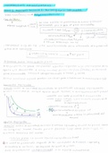
● In the figure we can see that the land rises from 0 m at sea level to 125 m
at the top of the hill.
● The map also shows that there is a 20 m height difference between each
contour - this is the contour interval.
● A contour line is a line drawn on a topographic map to indicate an
elevation or depression of the ground.
● A contour interval is a vertical distance or difference in elevation
between contour lines.
● Index contours are bold or thicker lines that appear every fifth contour
line.
SOCIAL SCIENCE
Grade 9
,Concepts of
Contour Lines
Explore the fundamental principles and key features that define contour lines,
a crucial tool for understanding and interpreting topographical maps.
,How Contour Lines Work
Imaginary Lines Measurement Tools Topographic Maps
Contour lines are imaginary lines that Contour lines can be used to measure the On a map, contour lines represent the
connect points of the same elevation height of mountains, depth of seafloors, shape of the earth's surface, like a bird's
above sea level. and steepness of slopes. eye view of hills and valleys.
, Contour Lines and
Intervals
● In the figure we can see that the land rises from 0 m at sea level to 125 m
at the top of the hill.
● The map also shows that there is a 20 m height difference between each
contour - this is the contour interval.
● A contour line is a line drawn on a topographic map to indicate an
elevation or depression of the ground.
● A contour interval is a vertical distance or difference in elevation
between contour lines.
● Index contours are bold or thicker lines that appear every fifth contour
line.