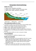
Geography-Geomorphology
stages of a river:
Lower course: Floodplains and deltas
Middle course: Valleys, meanders and oxbow lakes
Upper course: rapids, waterfalls, and gorges
The longitudinal profile of a river:
Longitudinal profile: Visual representation of the gradient down
which the river flows from the source to its mouth.
Upper course: steeper upstream towards the source.
Middle course: down stream towards the mouth.
Lower course: Final stage of a river as it gets closer to the sea.
The gradient of a river becomes less steep as it moves closer to
the sea.
The longitudinal profile of a river is concave in shape.
Fluvial landforms:
Fluvial landforms: Landforms created by rivers.
Rapids and waterfalls:
Rapids and waterfalls are fluvial landforms that form in areas
of high relief and steep gradient. Near the source, in the
upper part of the valley the river flows high above sea-level.
The gradient of the land is steep and the river has great
potential to erode.
Rapids: form when the river flows over a layer of resistant
rock that is inclined downstream, and the bed of the river is
, uneven and rocky. The change in gradient and the uneven
bed cause the flow of water to be turbulent.
Waterfalls: Form when a river crosses a horizontal or vertical
layer of resistant rock that is dipping upstream. The softer
rock is eroded by the flow of water leaving a steep drop in
the channel.
River meanders and alluvial fans:
Form in areas of a medium relief and a gradual gradient.
Meanders: Bends in the river channel.
Alluvial fans: Deposition as the river flows off the mountains
onto flatter plains.
Levees, braided streams, river meanders, oxbow lakes
and floodplains:
Form in areas of little relief and a gentle gradient.
Levees: Raised banks of a river
Braided streams: Deposits of alluvium in the middle of the
channel, splitting the river into separate channels.
Meander: Bend in a river
Oxbow lake and meander scar: Oxbow lake- a meander that
is cut off when a river takes a new course across the neck of
a meander loop. Meander scar- dried up oxbow lake.
Types of rivers: