MAPWORK
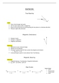
True Bearing
A
B
STEPS:
Draw a line through start point
Join two given places with a straight line
Draw an arrow from the True North joining the two places in a clockwise direction
Measure angle with protractor
Magnetic Declination
Change in years:
Change in ‘ (degrees):
Magnetic Declination:
FORMULA:
Difference in year x Annual change
Add this to True Bearing
If change is greater than 60’ then convert into degrees and minutes
o E.g. 75’ = 1° 15’
If annual change is given in east subtract from True Bearing
Magnetic Bearing
FORMULA:
Magnetic Bearing = True Bearing + Magnetic Declination
E.g. 140° + 18° 30’W = 158° 30’
Map Scales
Types of scales:
Linear
KM M CM MM Representative
fraction (ratio)
X 1000 ÷ X 100 ÷ X 10 ÷ Word
, Grid References & Exact Positions
STEPS:
1. Divide grid into 4 blocks
2. Find the block that contains your area
3. Divide the Longitude and Latitude line of
your block into minutes, annotating them
along the line
4. Divide your block into 4 parts
5. Draw two straight lines connecting your area
to the longitude and latitude line
6. Find the minute closest to your line
7. Add the result to the degree of your block
Latitude = North or South
Longitude = East or west 20° N 35° W (Latitude comes first)
Vertical Exaggeration
The vertical exaggeration is the amount by which the vertical scale of a cross-section
is larger than the horizontal scale
FORMULA: STEPS:
VS (vertical scale) To determine the vertical scale, refer to the scale
VE (vertical exaggeration) = given when asked to draw a cross-section
HS (horizontal scale)
E.g. 5mm = 50m in reality
This scale then needs to be converted into centimeter
units
Cross-section As all units have been converted into centimeters,
enter units into formula
1
VS VS 1 HS
VE = = = x = … times
HS 1 VS 1
HS
Altitude
Shown in four ways:
Spot height 1727 Trig beacons
298
, Bench mark 1629,9 Contour lines
Gradient
FORMULA: STEPS:
Difference∈height Measure the distance between the two points
Gradient =
Difference∈distance Convert that measurement into meters using
the Map Scale
Find the difference between the heights of
both points
Divide the distance between the two points
3 by the result found above
E.g.
1
1124 m−1060 m=64 m
A 1:3 gradient showing a steep slope 2,5 cm x 0,5=1,25 km x 1000=1250 m
64 /64
¿
1250/64
1
1
¿
10 19,53
A 1:10 gradient showing a gentle slope
Weather Station Model
The direction of the arrow
indicates wind direction.
Shows the max temperature The extended lines dictate wind
in ℃ speed
o The long line = 10 knots
o The short line = 5 knots
The shaded area represents
cloud coverage
Shows the dew point
temperature in ℃