Monday 29th November 2021 LEC 172
Volcanism & Plutonism – 2
Kettle Hoe – Depression left behind when an ice block beneath the surface has melted and caused the
overlying sediment to collapse in/sink in an isolated shape, due to the decrease in volume.
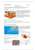
Igneous Intrusions:
= Molten igneous material (magma), with a high temp and
the ability to flow, that migrates through the crust until it
reaches its level of mutual buoyancy (where it’s a similar
density of the country (surrounding) rock) and fills in any
spaces before slowly solidifying.
Information on the shapes and volumes of intrusions
gained from field work/visual observations, geophysical
surveying (seismic/gravity/radar surveys), underground
mapping and drilling (or cores).
Pluton = 100’s Km3 in volume igneous bodies.
Batholith = Larger versions of plutons. <&^Both solidified magma chambers.
Sill = Igneous structures (concordant) parallel to the local sedimentary succession (intrusions in horizontal
strata).
Dike = Cross-cutting igneous intrusions (discordant).
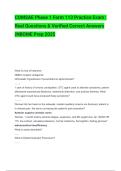
Geological Sketch Map of Devon/Cornwall Batholiths:
The Cornubian granite batholith is a solidified
magma chamber, that crystallised ~300 Ma ago.
It may have fed volcanoes at the surface but if
so, the volcanic rocks have long since been
eroded.
Red – visible batholith.
Pink - Gained from geophysical methods.
Geological map of the SW Peninsula of NW Scotland – Island of
Mull:
Ross of Mull granite pluton, Isle of Mull, Scotland, UK;
crystallised 418 Ma ago
Basalt Dyke:
Basalt dyke, approx 10 m wide,
intruded into shale, Grand
Canyon National Park, Arizona,
USA
, Basalt Dyke:
Basalt dyke, approx 1 m wide, in caldera wall of Sollipulli, Chile. 2200m
Above Sea level.
Sill Example:
Near horizontal mafic sill of the Ferrar Dolerite (dark) intruded into Beacon
Sandstone (light) at the margin of Taylor Glacier, Antarctica
< Volcanic neck 515 m above surrounding flat-
lying sediments, with radiating dykes, Shiprock,
New Mexico, USA
Classification of Igneous Rocks:
Igneous rocks can be classified by determining the silica
content (weight % of SiO…), grain size
(fine/medium/coarse) or the rocks proportion of minerals.
Volcanism & Plutonism – 2
Kettle Hoe – Depression left behind when an ice block beneath the surface has melted and caused the
overlying sediment to collapse in/sink in an isolated shape, due to the decrease in volume.
Igneous Intrusions:
= Molten igneous material (magma), with a high temp and
the ability to flow, that migrates through the crust until it
reaches its level of mutual buoyancy (where it’s a similar
density of the country (surrounding) rock) and fills in any
spaces before slowly solidifying.
Information on the shapes and volumes of intrusions
gained from field work/visual observations, geophysical
surveying (seismic/gravity/radar surveys), underground
mapping and drilling (or cores).
Pluton = 100’s Km3 in volume igneous bodies.
Batholith = Larger versions of plutons. <&^Both solidified magma chambers.
Sill = Igneous structures (concordant) parallel to the local sedimentary succession (intrusions in horizontal
strata).
Dike = Cross-cutting igneous intrusions (discordant).
Geological Sketch Map of Devon/Cornwall Batholiths:
The Cornubian granite batholith is a solidified
magma chamber, that crystallised ~300 Ma ago.
It may have fed volcanoes at the surface but if
so, the volcanic rocks have long since been
eroded.
Red – visible batholith.
Pink - Gained from geophysical methods.
Geological map of the SW Peninsula of NW Scotland – Island of
Mull:
Ross of Mull granite pluton, Isle of Mull, Scotland, UK;
crystallised 418 Ma ago
Basalt Dyke:
Basalt dyke, approx 10 m wide,
intruded into shale, Grand
Canyon National Park, Arizona,
USA
, Basalt Dyke:
Basalt dyke, approx 1 m wide, in caldera wall of Sollipulli, Chile. 2200m
Above Sea level.
Sill Example:
Near horizontal mafic sill of the Ferrar Dolerite (dark) intruded into Beacon
Sandstone (light) at the margin of Taylor Glacier, Antarctica
< Volcanic neck 515 m above surrounding flat-
lying sediments, with radiating dykes, Shiprock,
New Mexico, USA
Classification of Igneous Rocks:
Igneous rocks can be classified by determining the silica
content (weight % of SiO…), grain size
(fine/medium/coarse) or the rocks proportion of minerals.