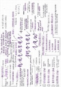
COMMERCIAL PILOT LICENCE (CPL)
NAVIGATION – CNAV
OBLATE SPHEROID
● Sphere that’s pushed in at the top and bottom
● Actual shape of earth
EQUATOR
● Line perpendicular to the earth’s axis of rotation, that cuts the earth
into two equal halves
PARALLELS OF LATITUDE
● Lines parallel to the equator
● Each “circle” is smaller than the equator line
● Measured north or south of the equator, up to 90 degrees
MERIDIANS OF LONGITUDE
● Lines parallel to the earth’s axis of rotation, going from north to south
● Each “semi-circle” is the same size as each other
● Measured east and west of the prime meridian, up to 180 degrees
PRIME MERIDIAN
● Designated 0 degree meridian
● Passes through Greenwich, England
ANTI-MERIDIAN
● Opposite meridian to the prime meridian, located at 180 degrees
east/west
● Passes through the Pacific Ocean
,CO-ORDINATES
● Latitude and longitude positions defining a point on earth
● Displayed as degrees, minutes and seconds
TRUE DIRECTION
● Measuring direction relative to true north, designated at 0 degrees,
up to 359 degrees clockwise
TRUE NORTH
● Direction facing the geographic North Pole, being where the earth’s
axis of rotation touches the surface at the top
RHUMB LINE
● A line that cuts meridians at the same angle
● Only straight when following a meridian north-south
● Otherwise line curves concave to the pole
GREAT CIRCLE
● Line cutting the earth into two equal halves
● Includes all meridians and the equator
● Produces the shortest path between two points on the earth
● Cuts meridians at different angles
MAGNETIC DIRECTION
● Measuring direction relative to magnetic north, designated at 0
degrees, up to 359 degrees clockwise
MAGNETIC NORTH
● Direction facing the magnetic North Pole, being set by the earth’s
magnetic field
, MAGNETIC VARIATION
● Difference between true direction and magnetic direction
● Varies depending on location
● Variation east, magnetic least
● Variation west, magnetic best
ISOGONAL LINE
● Line joining points of equal magnetic variation
COMPASS DEVIATION
● Difference between magnetic direction and compass direction
● As a result of aircraft instruments and systems producing magnetic
effects on the compass
● Measured by conducting a compass swing
● Presented in the cockpit as a compass deviation card
MERCATOR PROJECTION
● A theoretical earth as if projected onto a cylinder
● Line of tangency is the equator
● Size of areas correct at line of tangency, being the equator
● Distortion in the form of stretching occurs moving away from the
equator, meaning scale also changes
● Meridians and latitude lines are straight and perpendicular to each
other
● Rhumb lines are straight
● Great circle lines are convex to the nearest pole
LINE OF TANGENCY/STANDARD PARALLEL
● Where the theoretical earth touches the cylinder it is being projected
onto