Atmospheric circulation Global heat transfers
The atmosphere is the layer of air surrounding the earth’s The earth’s climate can be influenced by the atmosphere
surface. Within the atmosphere the air is constantly moving in and the oceans, heat/energy can be moved around the
different directions- these movements causse air to circulate, globe atmospherically or by oceans through circulation.
following patterns.
Creating atmospheric circulation
Low & High pressure
1. Low pressure-> When air next to the ground is heated, it Air in the atmosphere moves
expands, gets lighter and rises. The amount of air near the both up and down and side to
ground decreases so an area of low pressure is formed side. This vertical and
horizontal movement of air
2. High pressure-> When air is cooled, it becomes denser and causes changes in air pressure.
heavier, so it descends. The amount of air near the ground
increases so an area of high pressure is formed Low pressure
-high rainfall
3. Prevailing winds->Air moves as winds, from areas of high -cloudy, rainy, windy
pressure to areas of low pressure and creates prevailing winds. -Depressions
Most prevailing winds are from the south west.
High pressure
These three processes create circular -low rainfall
movements (cells) in each hemisphere. -no clouds, clear sky
-anticyclones
Why is it hotter at the equator?
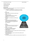
Atmospheric circulation model As the earth is round, the equator sticks out
The Hadley cell: the most. When solar radiation hits the
At the equator, hot, moist air rises, equator, the radiation is more concentrated
moves to higher latitudes (30) so the land will heat up more and quicker –
The Ferrel cell: Heating the air above it. The same amount of
At around 60 either side of the equator, radiation is spread out at the poles, making it
moist air rises, and travels to lower cooler.
latitudes (30) to sinks
The Polar cell:
At 60 north or south of the equator,
moist air rises and travels to the poles
(90), where it sinks
Oceanic circulation
-Ocean currents are movements of surface water
-Currents flowing away from the equator are warm currents
(e.g gulf stream) whilst currents flowing towards the equator
are cold currents (e.g The canaries current)
-the prevailing wind creates friction with surface water and
currents are produced
-The Coriolis effect deflects the currents right in the
northern hemisphere and left in the southern hemisphere,
because of the earth’s rotation Inter-tropical convergence zone (ITCZ)
-Cold dense polar waters sink, then spreads towards the An area surrounded the equator where winds from the
equator where it pushes up the less dense warmer water northern and southern hemisphere meet (converge)
which moves off towards the polar areas. causes low pressure.
Where Hadley cells meet.
, Approximately every 100,000 years the orbit of the earth
changes. This causes interglacial (warmer) and glacial
(cooler) periods. This happens because of eccentricity
Asteroid
Natural collisions
causes of climate change Orbital changes (Milankovitch cycles)
Climate
When there is isa any
change change
collision, in global
large temperatures
amounts of dust andand Over periods of time, the orbit of the earth changes, it
precipitation over time,
debris are ejected intodue
the to natural or human
atmosphere. activities.
This causes a goes from a circular to an oval shape. When the orbit
blanket which blocks solar radiation and cools down is elliptical the earth is further away from the sun, the
the earth. temperature of the earth is cooler. When it is circular,
it is warmer- this is eccentricity.
It is theorised that it was a huge
asteroid collision that led to the
ice age.
Volcanic activity Variations in solar output
The amount of radiation the sun
The ashes and gas from an
Produces varies over time.
Eruption, can go hundreds of
Periods of low solar activity are
Kilometres into the air and will
Likely to lead to glacial periods whereas high solar
Act like a blanket- trapping radiation and cooling the
Activity may warm the earth.
earth.
Sunspots are an example of variation in solar output. A
This reduction in surface temperature is known as a
sunspot emits a large amount of solar radiation. In a
volcanic winter.
11-year cycle the amount of sunspots change from a
minimum to a maximum. Minimum= less solar output
Ice cores:
-> Done by drilling 3km deep in the ice, this can represent climate up to 800,000 years ago.
-> In each ice core, there is half a meter of ice.
-> Ice forms in different layers representing each year
-> When ice forms, it traps bubbles of atmosphere, this can be tested to see levels of CO2.
-> The more CO2 in the atmosphere, the warmer the temperature was.
-> Also, the composition of water can be tested for isotope levels showing the temperature
at that time.
Tree rings:
-> Can be used to reconstruct the climate that trees used to grow in, records go back 10,000 yrs
-> Scientists can use tree rings to distinguish which conditions were favourable for tree growth.
->As trees grow they produce growth rings every year- if ring is larger, tree grew more that year
-> Trees are sensitive to changes in temperature, sunlight and precipitation.
-> Rings are wider in warmer, wetter climates & narrower in cooler, drier climates.
-> Also represent when a tree stopped growing such as in winter
-> Red wood trees are useful as they are immune to disease and don’t catch fire
-> Tree rings are quite reliable but only show local climates
Historical sources:
-> sources which humans created that can be used to gain an understanding about
past climates
Evidencebefore accurate
for natural temperature
climate change measurements were taken.
-> Painting can show what the past landscape was like, e.g to the right the river
Thames is frozen during the little ice age (1300- 1860)
-> Books, journals and newspaper can be used to date any extreme weather events
-> Can be inaccurate because they did not set out to record climates so may be
inaccurate and also are usually local and difficult to generalise.
The atmosphere is the layer of air surrounding the earth’s The earth’s climate can be influenced by the atmosphere
surface. Within the atmosphere the air is constantly moving in and the oceans, heat/energy can be moved around the
different directions- these movements causse air to circulate, globe atmospherically or by oceans through circulation.
following patterns.
Creating atmospheric circulation
Low & High pressure
1. Low pressure-> When air next to the ground is heated, it Air in the atmosphere moves
expands, gets lighter and rises. The amount of air near the both up and down and side to
ground decreases so an area of low pressure is formed side. This vertical and
horizontal movement of air
2. High pressure-> When air is cooled, it becomes denser and causes changes in air pressure.
heavier, so it descends. The amount of air near the ground
increases so an area of high pressure is formed Low pressure
-high rainfall
3. Prevailing winds->Air moves as winds, from areas of high -cloudy, rainy, windy
pressure to areas of low pressure and creates prevailing winds. -Depressions
Most prevailing winds are from the south west.
High pressure
These three processes create circular -low rainfall
movements (cells) in each hemisphere. -no clouds, clear sky
-anticyclones
Why is it hotter at the equator?
Atmospheric circulation model As the earth is round, the equator sticks out
The Hadley cell: the most. When solar radiation hits the
At the equator, hot, moist air rises, equator, the radiation is more concentrated
moves to higher latitudes (30) so the land will heat up more and quicker –
The Ferrel cell: Heating the air above it. The same amount of
At around 60 either side of the equator, radiation is spread out at the poles, making it
moist air rises, and travels to lower cooler.
latitudes (30) to sinks
The Polar cell:
At 60 north or south of the equator,
moist air rises and travels to the poles
(90), where it sinks
Oceanic circulation
-Ocean currents are movements of surface water
-Currents flowing away from the equator are warm currents
(e.g gulf stream) whilst currents flowing towards the equator
are cold currents (e.g The canaries current)
-the prevailing wind creates friction with surface water and
currents are produced
-The Coriolis effect deflects the currents right in the
northern hemisphere and left in the southern hemisphere,
because of the earth’s rotation Inter-tropical convergence zone (ITCZ)
-Cold dense polar waters sink, then spreads towards the An area surrounded the equator where winds from the
equator where it pushes up the less dense warmer water northern and southern hemisphere meet (converge)
which moves off towards the polar areas. causes low pressure.
Where Hadley cells meet.
, Approximately every 100,000 years the orbit of the earth
changes. This causes interglacial (warmer) and glacial
(cooler) periods. This happens because of eccentricity
Asteroid
Natural collisions
causes of climate change Orbital changes (Milankovitch cycles)
Climate
When there is isa any
change change
collision, in global
large temperatures
amounts of dust andand Over periods of time, the orbit of the earth changes, it
precipitation over time,
debris are ejected intodue
the to natural or human
atmosphere. activities.
This causes a goes from a circular to an oval shape. When the orbit
blanket which blocks solar radiation and cools down is elliptical the earth is further away from the sun, the
the earth. temperature of the earth is cooler. When it is circular,
it is warmer- this is eccentricity.
It is theorised that it was a huge
asteroid collision that led to the
ice age.
Volcanic activity Variations in solar output
The amount of radiation the sun
The ashes and gas from an
Produces varies over time.
Eruption, can go hundreds of
Periods of low solar activity are
Kilometres into the air and will
Likely to lead to glacial periods whereas high solar
Act like a blanket- trapping radiation and cooling the
Activity may warm the earth.
earth.
Sunspots are an example of variation in solar output. A
This reduction in surface temperature is known as a
sunspot emits a large amount of solar radiation. In a
volcanic winter.
11-year cycle the amount of sunspots change from a
minimum to a maximum. Minimum= less solar output
Ice cores:
-> Done by drilling 3km deep in the ice, this can represent climate up to 800,000 years ago.
-> In each ice core, there is half a meter of ice.
-> Ice forms in different layers representing each year
-> When ice forms, it traps bubbles of atmosphere, this can be tested to see levels of CO2.
-> The more CO2 in the atmosphere, the warmer the temperature was.
-> Also, the composition of water can be tested for isotope levels showing the temperature
at that time.
Tree rings:
-> Can be used to reconstruct the climate that trees used to grow in, records go back 10,000 yrs
-> Scientists can use tree rings to distinguish which conditions were favourable for tree growth.
->As trees grow they produce growth rings every year- if ring is larger, tree grew more that year
-> Trees are sensitive to changes in temperature, sunlight and precipitation.
-> Rings are wider in warmer, wetter climates & narrower in cooler, drier climates.
-> Also represent when a tree stopped growing such as in winter
-> Red wood trees are useful as they are immune to disease and don’t catch fire
-> Tree rings are quite reliable but only show local climates
Historical sources:
-> sources which humans created that can be used to gain an understanding about
past climates
Evidencebefore accurate
for natural temperature
climate change measurements were taken.
-> Painting can show what the past landscape was like, e.g to the right the river
Thames is frozen during the little ice age (1300- 1860)
-> Books, journals and newspaper can be used to date any extreme weather events
-> Can be inaccurate because they did not set out to record climates so may be
inaccurate and also are usually local and difficult to generalise.