Tectonic hazards and processes 1 of 21
Key:
EQ= earthquakes
VE= volcanic eruptions
T= tsunamis
TE= tectonic event
TH= tectonic hazard
Enquiry question 1: Why are some locations more at risk from tectonic hazards?
Key words:
Hazard-a potential threat to human life and property.
Natural hazard- a naturally occurring event with potential to cause loss of life or property.
Natural disaster- when a natural hazard causes social, environmental and economic damage. E.g.
when a vulnerable populations can’t cope using its own resources.
Vulnerability- people’s ability to cope with hazard events. The greater the hazard and more vulnerable
the people, the greater the disaster.
Mantle- a solid, but because of the very high temperatures present it is deformable (plastic) and
capable of very slow ‘flow’.
The oceanic fracture zone (OFZ)- a belt of activity through the oceans along the mid-ocean ridges,
coming ashore in Africa, the Red Sea, the Dead Sea rift and California.
The continental fracture zone (CFZ)- a belt of activity following the mountain ranges from Spain via
the Alps, to the Middle East, the Himalayas to the East Indies and the circumscribing the Pacific.
Plate boundaries- form where two tectonic plates meet.
Oceanic crust- a thin dense layer (6-10km thick), forming ocean floors.
Continental crust- a thicker, less dense layer (45-50km thick), which makes up landmasses.
Asthenosphere- the part of the mantle, below the lithosphere, where the rock is semi-molten.
Lithosphere- the solid layer, made from the crust and upper mantle, from which tectonic plates are
formed.
Mid-oceanic ridge- an underwater mountain range, formed by plate tectonics. This uplifting of the
ocean floor occurs when convection currents rise in the mantle beneath the oceanic crust and create
magma where two tectonic plates meet at a divergent boundary.
Deep ocean trench- a deep ditch in the ocean, marking the place where an oceanic plate starts to sink
beneath a continental plate.
Faults- parallel cracks.
Rift valley- a steep-sided valley formed by the downward displacement of a block of the earth's
surface between nearly parallel faults or fault systems.
Horsts- lifted areas of rocks, in continental to continental divergent plate boundaries.
Graben- the valley itself, in continental to continental divergent plate boundaries.
Hypocentre- is the ‘focus’ point within the ground where the strain energy of the earthquake stored in
the rock is first released.
Focal length- the distance between the hypocentre and the epicentre on the surface.
Mantle plume- are concentrated areas of heat convection. At plate-boundaries they are sheet-like,
whereas at hot spots they are column-like.
Island arcs- a curved chain of volcanic islands located at a tectonic plate margin, typically with a deep
ocean trench on the convex side.
Submarine volcanoes- underwater volcanoes in the Earth's surface from which magma can erupt.
Many submarine volcanoes are located near areas of tectonic plate formation, known as mid-ocean
ridges.
Fold mountains- occur when sediment is pushed upwards during subduction.
Transform faults- a strike-slip fault occurring at the boundary between two plates of the earth's crust.
Intra- plate earthquakes- earthquakes that occur near the middle of plates.
Convection currents- hot, liquid magma currents moving in the asthenosphere.
Palaeomagnetism- the study of past changes in the Earth’s magnetic field.
Seafloor spreading- when new oceanic crust- formed when hot magma is forced up from the
asthenosphere and hardens- pushes the tectonic plates apart.
Slab pull- when newly formed oceanic crust sinks into the mantle, pulling the rest of the plate further
down with it.
Subduction- when two plates move towards each other and one sides under the other into the mantle.
Benioff zone- the area where friction is created between colliding tectonic plates, resulting in
intermediate and deep earthquakes.
,Tectonic hazards and processes 2 of 21
Collision margins- where two continental plates meet and the sediments between them are crumpled
and forced up to form high fold mountain.
Constructive plate margin- where two plates me apart, also known as a divergent boundary.
Convergent boundary- where two plates move towards each other and collide, also known as a
destructive margin.
Conservative margin- where two plates slide past each other, also known as a transform margin.
Earthquakes- are sudden releases of stored energy that typically causes great destruction, as a result
of movements within the earth's crust or volcanic action.
Aftershock- a smaller earthquake that follows a larger earthquake, in the same area of the main shock,
caused as the displaced crust adjusts to the effects of the main shock.
Water column- the area of seawater from the surface to the sea floor.
1.1 The global distribution of tectonic hazards can be explained by plate boundary and other tectonic
processes.
a. The global distribution and causes of earthquakes,
volcanic eruptions and tsunamis.
• A natural hazard can be either hydro-meteorological
(caused by climatic processes) or geophysical (caused by
land processes).
• Geophysical hazards occur near plate boundaries, as
plates move at different speeds and directions which can
cause collisions resulting in TEs.
• Overlap between the terms hazard and disaster and
people’s vulnerability, is shown by Degg’s disaster model.
• THs (EQs, VE, T) occur in specific locations, related to
tectonic plate boundaries and other tectonic settings.
• Distribution is uneven, some areas at higher risk than
others.
• TEs can generate multiple hazards when they occur.
• All THs caused by Earth’s internal heat engine. Radioactive decay of isotopes in the Earth’s core along
with primordial heat left over from the big bang and mantle generate huge amounts of heat which flow
towards the Earth’s surface.
• Heat flow generates convection currents in the plastic mantle. Therefore the interior of Earth is
dynamic rather than static.
• Most THs occur at plate boundaries, representing locations of ascending (divergent) and descending
(convergent) arms of mantle convection cells.
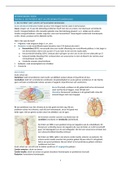
b. The distribution of plate boundaries resulting from divergent, convergent and conservative plate
movements (oceanic, continental and combined situations).
Plate boundary types depend on: motion (moving apart, colliding or sliding past each other) and plate
type (continental or oceanic).
Two different types of crust:
• Oceanic- low density, mainly basalt, thin, newer.
• Continental- high density, mainly granite, thick, old.
, Tectonic hazards and processes 3 of 21
Boundary type Plate type Example Description Hazards
Divergent/ Oceanic-Oceanic Mid-Atlantic ridge, • Plates diverge. Minor,
Constructive Iceland • Magma rises in between the shallow EQs
margins gap due to rising convection
(Two plates move currents and small, basaltic
apart) eruptions.
• Forms new oceanic plate when
it cools, mid oceanic ridge.
• VEs cause submarine
volcanoes.
Continental- African Rift Valley/ • Caused by a recent mantle Basaltic
Continental Red Sea plume splitting a continental volcanoes
plate to create a new oceanic Minor EQs
basin.
• Volcanoes form where the
magma rises, in the gap.
• Form where the crust forms
parallel cracks (faults) and the
land between them collapses.
Convergent/ Continental- Himalayas • Collision of two continental Infrequent
Destructive margins Continental plates creating a mountain belt major EQs
(Two plates collide) as they crumple. distributed
• Collision margin occurs, forcing over a wide
rock to form high fold area
mountains. No volcanic
• No subduction of continental activity
crust, slight oceanic.
Oceanic-Oceanic Aleutian Islands, • One oceanic plate is subducted Frequent,
Alaska beneath another, lighter one. violent EQs
• Fold mountains occur.
• Deep oceanic trenches and
volcanoes form.
• Submarine volcanoes grow to
form island volcanoes (island
arcs).
Oceanic- Andean Mountains • Oceanic plate is subducted Frequent,
Continental underneath a continental plate, large EQs
creating a volcanic mountain Violent VEs
range. (composite)
• Continental crust slides into the
asthenosphere and melts,
marked by deep ocean
trenches.
Key:
EQ= earthquakes
VE= volcanic eruptions
T= tsunamis
TE= tectonic event
TH= tectonic hazard
Enquiry question 1: Why are some locations more at risk from tectonic hazards?
Key words:
Hazard-a potential threat to human life and property.
Natural hazard- a naturally occurring event with potential to cause loss of life or property.
Natural disaster- when a natural hazard causes social, environmental and economic damage. E.g.
when a vulnerable populations can’t cope using its own resources.
Vulnerability- people’s ability to cope with hazard events. The greater the hazard and more vulnerable
the people, the greater the disaster.
Mantle- a solid, but because of the very high temperatures present it is deformable (plastic) and
capable of very slow ‘flow’.
The oceanic fracture zone (OFZ)- a belt of activity through the oceans along the mid-ocean ridges,
coming ashore in Africa, the Red Sea, the Dead Sea rift and California.
The continental fracture zone (CFZ)- a belt of activity following the mountain ranges from Spain via
the Alps, to the Middle East, the Himalayas to the East Indies and the circumscribing the Pacific.
Plate boundaries- form where two tectonic plates meet.
Oceanic crust- a thin dense layer (6-10km thick), forming ocean floors.
Continental crust- a thicker, less dense layer (45-50km thick), which makes up landmasses.
Asthenosphere- the part of the mantle, below the lithosphere, where the rock is semi-molten.
Lithosphere- the solid layer, made from the crust and upper mantle, from which tectonic plates are
formed.
Mid-oceanic ridge- an underwater mountain range, formed by plate tectonics. This uplifting of the
ocean floor occurs when convection currents rise in the mantle beneath the oceanic crust and create
magma where two tectonic plates meet at a divergent boundary.
Deep ocean trench- a deep ditch in the ocean, marking the place where an oceanic plate starts to sink
beneath a continental plate.
Faults- parallel cracks.
Rift valley- a steep-sided valley formed by the downward displacement of a block of the earth's
surface between nearly parallel faults or fault systems.
Horsts- lifted areas of rocks, in continental to continental divergent plate boundaries.
Graben- the valley itself, in continental to continental divergent plate boundaries.
Hypocentre- is the ‘focus’ point within the ground where the strain energy of the earthquake stored in
the rock is first released.
Focal length- the distance between the hypocentre and the epicentre on the surface.
Mantle plume- are concentrated areas of heat convection. At plate-boundaries they are sheet-like,
whereas at hot spots they are column-like.
Island arcs- a curved chain of volcanic islands located at a tectonic plate margin, typically with a deep
ocean trench on the convex side.
Submarine volcanoes- underwater volcanoes in the Earth's surface from which magma can erupt.
Many submarine volcanoes are located near areas of tectonic plate formation, known as mid-ocean
ridges.
Fold mountains- occur when sediment is pushed upwards during subduction.
Transform faults- a strike-slip fault occurring at the boundary between two plates of the earth's crust.
Intra- plate earthquakes- earthquakes that occur near the middle of plates.
Convection currents- hot, liquid magma currents moving in the asthenosphere.
Palaeomagnetism- the study of past changes in the Earth’s magnetic field.
Seafloor spreading- when new oceanic crust- formed when hot magma is forced up from the
asthenosphere and hardens- pushes the tectonic plates apart.
Slab pull- when newly formed oceanic crust sinks into the mantle, pulling the rest of the plate further
down with it.
Subduction- when two plates move towards each other and one sides under the other into the mantle.
Benioff zone- the area where friction is created between colliding tectonic plates, resulting in
intermediate and deep earthquakes.
,Tectonic hazards and processes 2 of 21
Collision margins- where two continental plates meet and the sediments between them are crumpled
and forced up to form high fold mountain.
Constructive plate margin- where two plates me apart, also known as a divergent boundary.
Convergent boundary- where two plates move towards each other and collide, also known as a
destructive margin.
Conservative margin- where two plates slide past each other, also known as a transform margin.
Earthquakes- are sudden releases of stored energy that typically causes great destruction, as a result
of movements within the earth's crust or volcanic action.
Aftershock- a smaller earthquake that follows a larger earthquake, in the same area of the main shock,
caused as the displaced crust adjusts to the effects of the main shock.
Water column- the area of seawater from the surface to the sea floor.
1.1 The global distribution of tectonic hazards can be explained by plate boundary and other tectonic
processes.
a. The global distribution and causes of earthquakes,
volcanic eruptions and tsunamis.
• A natural hazard can be either hydro-meteorological
(caused by climatic processes) or geophysical (caused by
land processes).
• Geophysical hazards occur near plate boundaries, as
plates move at different speeds and directions which can
cause collisions resulting in TEs.
• Overlap between the terms hazard and disaster and
people’s vulnerability, is shown by Degg’s disaster model.
• THs (EQs, VE, T) occur in specific locations, related to
tectonic plate boundaries and other tectonic settings.
• Distribution is uneven, some areas at higher risk than
others.
• TEs can generate multiple hazards when they occur.
• All THs caused by Earth’s internal heat engine. Radioactive decay of isotopes in the Earth’s core along
with primordial heat left over from the big bang and mantle generate huge amounts of heat which flow
towards the Earth’s surface.
• Heat flow generates convection currents in the plastic mantle. Therefore the interior of Earth is
dynamic rather than static.
• Most THs occur at plate boundaries, representing locations of ascending (divergent) and descending
(convergent) arms of mantle convection cells.
b. The distribution of plate boundaries resulting from divergent, convergent and conservative plate
movements (oceanic, continental and combined situations).
Plate boundary types depend on: motion (moving apart, colliding or sliding past each other) and plate
type (continental or oceanic).
Two different types of crust:
• Oceanic- low density, mainly basalt, thin, newer.
• Continental- high density, mainly granite, thick, old.
, Tectonic hazards and processes 3 of 21
Boundary type Plate type Example Description Hazards
Divergent/ Oceanic-Oceanic Mid-Atlantic ridge, • Plates diverge. Minor,
Constructive Iceland • Magma rises in between the shallow EQs
margins gap due to rising convection
(Two plates move currents and small, basaltic
apart) eruptions.
• Forms new oceanic plate when
it cools, mid oceanic ridge.
• VEs cause submarine
volcanoes.
Continental- African Rift Valley/ • Caused by a recent mantle Basaltic
Continental Red Sea plume splitting a continental volcanoes
plate to create a new oceanic Minor EQs
basin.
• Volcanoes form where the
magma rises, in the gap.
• Form where the crust forms
parallel cracks (faults) and the
land between them collapses.
Convergent/ Continental- Himalayas • Collision of two continental Infrequent
Destructive margins Continental plates creating a mountain belt major EQs
(Two plates collide) as they crumple. distributed
• Collision margin occurs, forcing over a wide
rock to form high fold area
mountains. No volcanic
• No subduction of continental activity
crust, slight oceanic.
Oceanic-Oceanic Aleutian Islands, • One oceanic plate is subducted Frequent,
Alaska beneath another, lighter one. violent EQs
• Fold mountains occur.
• Deep oceanic trenches and
volcanoes form.
• Submarine volcanoes grow to
form island volcanoes (island
arcs).
Oceanic- Andean Mountains • Oceanic plate is subducted Frequent,
Continental underneath a continental plate, large EQs
creating a volcanic mountain Violent VEs
range. (composite)
• Continental crust slides into the
asthenosphere and melts,
marked by deep ocean
trenches.