GRADE 8 GEOGRAPHY
Unit 1 Maps and atlases Lines of latitude, longitude form a grid that covers
Latitude and longitude – degrees and minutes earth.
We used cardinal points (north, south, east, west) to Know latitude, longitude / co-ordinates of a place, we
describe where one place is in relation to another. can find that place on a map.
Use a grid to help you to locate places on a map.
Many atlas maps use a special kind of grid to help us to
locate places.
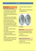
This grid is made up of lines of latitude +longitude.
Lines of latitude = lines that run across a globe / map.
Longest line of latitude, 0° line, equator.
Other lines of latitude run parallel to equator.
Each line is numbered in degrees, from 0° at equator
to 90° north at North Pole, 90° south at South Pole.
Refer to latitude of a place as number of degrees north
Latitude and longitude
/ south of equator.
Lines of longitude - lines on globe / map that join
Degrees and minutes
North, South Poles.
Easier to measure latitude, longitude with degrees
0° line of longitude runs through a place called
More accurate to divide each degree up into smaller
Greenwich, near London, England.
units = minutes
Line of longitude =he Greenwich meridian / prime
Each degree consists of 60 minutes
meridian.
All other lines of longitude are east / west of this line.
Using the atlas index to find places on a map
Refer to longitude of a place as number of degrees
Index at the back of an atlas – all you need to know to
east / west of Greenwich meridian.
locate places on maps
Town – country - state – direction, minutes
, GRADE 8 GEOGRAPHY
Kinds of scale in an atlas (world, regional, local)
Remember a small-scale map gives a small amount of
detail about an area.
Examples of these maps = maps of the world / maps of
continents.
Large-scale map gives a large amount of detail about
an area. Calculate distances between settlements (global and
Examples of maps = maps of provinces / towns. South Africa) using different scales
In atlas, most maps have scale shown underneath map Use scale of map to calculate distances between
/ at side of map. places.
Scale can be shown in three ways: Use word scale, ratio scale / line scale.
− Word scale, Often easier to use line scale to calculate distances.
− Line scale How to use line scale – steps:
− Ratio scale.
Scale
Review line and world scales
Scale = real distance on ground = 1 cm on map.
Line scale for world scale – 1cm represents 30km
Introduction to ratio scales
Ratio scale shows ratio of 1cm on the map to number
of centimeters in reality
, GRADE 8 GEOGRAPHY
Place straight edge of a piece of paper along map
between two points you want to measure the distance
between.
Mark positions of these two points on paper with a
pencil
Place strip of paper along line scale of map with mark
you made for Cape Town on “0”.
See where mark for Bloemfontein is on scale.
Read off distance in km. Hold end of thread at Cape Town, bend thread along
road to Bloemfontein
How to use a line scale to find an indirect distance
Remember you need a piece of thread, wool / thin
string to work out indirect distances - along rivers,
roads / railways.
Hold end of piece of thread on starting point. Stretch thread out along line scale for that map, read
Carefully bend tread along route to end point. off distance in km for other end of thread
Mark end point on thread with your finger.
Places in the news
Your teacher will put a map of world on classroom wall
with lots of space around it.
, GRADE 8 GEOGRAPHY
Bring news items from around world that interest you One of eight planets that move in orbit around sun.
to class. Earth is sphere-shaped.
Pin each news item on board surrounding world map, Half of sphere = hemisphere.
run string from news item to place on map where it Longest line of latitude, 0° line, = equator,
happened. Divides earth into two equal halves / hemispheres.
Chosen news item, look up place where event Region between North Pole + equator = northern
happened in index of atlas. hemisphere.
Write down latitude, longitude in degrees, minutes. Region between South Pole + equator = southern
Location of place, you can then find it on map of hemisphere.
world. 0° line of longitude / Greenwich meridian divides
world into western, eastern hemisphere.
The Globe Region between Greenwich meridian, +1800W line of
Hemisphere longitude - western hemisphere.
Region between Greenwich meridian + 1800E line of
longitude - eastern hemisphere.
The earth’s rotation on its axis – day and night
Earth turns all time on its axis, from west to east.
One complete turn = rotation.
Movement happens all the time, we do not notice it.
Travelling at a speed of about 1 600 km/h in order to
complete one rotation in 24 hours.
Important lines of latitude
Day and night
Globe - model of Earth. Every day we experience sunrise, daylight, sunset,
Earth = planet. darkness.
Unit 1 Maps and atlases Lines of latitude, longitude form a grid that covers
Latitude and longitude – degrees and minutes earth.
We used cardinal points (north, south, east, west) to Know latitude, longitude / co-ordinates of a place, we
describe where one place is in relation to another. can find that place on a map.
Use a grid to help you to locate places on a map.
Many atlas maps use a special kind of grid to help us to
locate places.
This grid is made up of lines of latitude +longitude.
Lines of latitude = lines that run across a globe / map.
Longest line of latitude, 0° line, equator.
Other lines of latitude run parallel to equator.
Each line is numbered in degrees, from 0° at equator
to 90° north at North Pole, 90° south at South Pole.
Refer to latitude of a place as number of degrees north
Latitude and longitude
/ south of equator.
Lines of longitude - lines on globe / map that join
Degrees and minutes
North, South Poles.
Easier to measure latitude, longitude with degrees
0° line of longitude runs through a place called
More accurate to divide each degree up into smaller
Greenwich, near London, England.
units = minutes
Line of longitude =he Greenwich meridian / prime
Each degree consists of 60 minutes
meridian.
All other lines of longitude are east / west of this line.
Using the atlas index to find places on a map
Refer to longitude of a place as number of degrees
Index at the back of an atlas – all you need to know to
east / west of Greenwich meridian.
locate places on maps
Town – country - state – direction, minutes
, GRADE 8 GEOGRAPHY
Kinds of scale in an atlas (world, regional, local)
Remember a small-scale map gives a small amount of
detail about an area.
Examples of these maps = maps of the world / maps of
continents.
Large-scale map gives a large amount of detail about
an area. Calculate distances between settlements (global and
Examples of maps = maps of provinces / towns. South Africa) using different scales
In atlas, most maps have scale shown underneath map Use scale of map to calculate distances between
/ at side of map. places.
Scale can be shown in three ways: Use word scale, ratio scale / line scale.
− Word scale, Often easier to use line scale to calculate distances.
− Line scale How to use line scale – steps:
− Ratio scale.
Scale
Review line and world scales
Scale = real distance on ground = 1 cm on map.
Line scale for world scale – 1cm represents 30km
Introduction to ratio scales
Ratio scale shows ratio of 1cm on the map to number
of centimeters in reality
, GRADE 8 GEOGRAPHY
Place straight edge of a piece of paper along map
between two points you want to measure the distance
between.
Mark positions of these two points on paper with a
pencil
Place strip of paper along line scale of map with mark
you made for Cape Town on “0”.
See where mark for Bloemfontein is on scale.
Read off distance in km. Hold end of thread at Cape Town, bend thread along
road to Bloemfontein
How to use a line scale to find an indirect distance
Remember you need a piece of thread, wool / thin
string to work out indirect distances - along rivers,
roads / railways.
Hold end of piece of thread on starting point. Stretch thread out along line scale for that map, read
Carefully bend tread along route to end point. off distance in km for other end of thread
Mark end point on thread with your finger.
Places in the news
Your teacher will put a map of world on classroom wall
with lots of space around it.
, GRADE 8 GEOGRAPHY
Bring news items from around world that interest you One of eight planets that move in orbit around sun.
to class. Earth is sphere-shaped.
Pin each news item on board surrounding world map, Half of sphere = hemisphere.
run string from news item to place on map where it Longest line of latitude, 0° line, = equator,
happened. Divides earth into two equal halves / hemispheres.
Chosen news item, look up place where event Region between North Pole + equator = northern
happened in index of atlas. hemisphere.
Write down latitude, longitude in degrees, minutes. Region between South Pole + equator = southern
Location of place, you can then find it on map of hemisphere.
world. 0° line of longitude / Greenwich meridian divides
world into western, eastern hemisphere.
The Globe Region between Greenwich meridian, +1800W line of
Hemisphere longitude - western hemisphere.
Region between Greenwich meridian + 1800E line of
longitude - eastern hemisphere.
The earth’s rotation on its axis – day and night
Earth turns all time on its axis, from west to east.
One complete turn = rotation.
Movement happens all the time, we do not notice it.
Travelling at a speed of about 1 600 km/h in order to
complete one rotation in 24 hours.
Important lines of latitude
Day and night
Globe - model of Earth. Every day we experience sunrise, daylight, sunset,
Earth = planet. darkness.