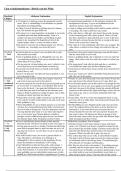
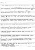
Geografie
graad 9
Kwartaal
1-4
Opgesom deur Annuscke Espach
, SW Opsommings
GEOGRAFIE
Graad 9
Topografiese en Ortofotokaarte
1. Topografiese kaarte
1.1 Kenmerke van topografiese kaarte
• ’n Vertikale lugfoto word geneem en deur ’n reknaar op die kaart geteken.
• Toon bou (topografie) van ’n land aan
• Toon verskynsels met behulp van kleure en simbole.
• Verklaring onder die kaart dui verskynsels aan. bv. kaartsimbole
• Kontoere word gebruik om hoogte aan te dui
• Die skaal is 1: 50 000
1.2 Skaal
Bv. 1:50 000
Een eenheid op die kaart is gelyk aan 50 000 eenhede in werklikheid.
- die werklikheid word verklein
1.3. Kenmerke van kontoere
• Kontoerlyne word gebruik, en kan ook hoogtelyne genoem word.
• Word in bruin geteken en altyd 20m uitmekaar.
• Indekskontoerlyn is donkerder.
• Stop en kruis nooit.
• Kan aanmekaar raak by waterval of krans.
• Kan landvorme voorstel. Bv. Valleie, uitlopers, butte, mesa’s en watervalle.
• Kan ook hellings voorstel, bv. steil (kontoere naby mekaar ) of geleidelike
helling (verder uit mekaar) of terrasvormige hellings (soos trapvorm)
Opgesom deur Annuscke Espach
, UITLOPER: ‘n hoogliggende gebied aan weerskante van ‘n vallei
*KYK PRENTE
Ander landvorme:
→ Saal: n hoe platterige rug tudden twee kruine van n berg
→ Rif: ‘n lang, nou hoogland met steil kante. Dit is langer as wat dit breed is.
1.4. Uitkenning van hoogte
1. Kontoerlyne
2. Punthoogte
3. Driehoeksbaken / Trigonometriese baken
4. Pylhoogte / Hoogtemerk
Kontoerinterval: die verskil in hoogte tussen 2 kontoerlyne langs mekaar (bv.
20m)
2. Ortofotokaart
1.1. Kenmerke van ’n Ortofotokaart
• ’n Lugfoto in swart en wit waarop kontoere aangedui is. (Landskap makliker
uitken)
• Skaal is 1: 10 000.
• Kontoere loop 5m uitmekaar.
3. Rigting
• Alle topografiese kaarte het ’n rigitngwyser. (Word
met ’n pyl en letter N aangedui.
• ’n Kompas word gebruik om die 16
kompaspunte voor te stel.
Opgesom deur Annuscke Espach