GCSE Geography River Landscapes in the UK
When the river loses energy, it drops any of the material it has been
carrying. This is deposition.
Factors leading to deposition include shallow water, when the volume of
the water decreases, when the river approaches its mouth (as the water
becomes shallower) and when the water has a slower velocity.
A river’s water can fluctuate over time. The hydrological cycle is useful in
order to understand how and why the amount of water fluctuates.
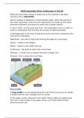
A drainage basin is the area of land around the river that is drained by the
river and its tributaries.
Watershed – the area of high land forming the edge of a river basin
Source – where a river begins
Mouth – where a river meets the sea
Confluence – the point at which two rivers meet
Tributary – a small river or stream that joins a larger river
Channel – this is where the river flows
River profiles
A long profile is a line representing the river from its source to its mouth.
It shows how the river changes over its course.
In the upper course, where the river starts, there is often an upland area.
The river’s load is large in the upper course, as it hasn’t been broken
down by erosion yet.
,In the lower course, the land is a lot flatter. The river’s load is fine
sediment as erosion has broken down the rocks.
A cross profile shows a cross-section of a river’s channel and valley at a
certain point along the river’s course.
A – as the river flows downhill there is an increase in vertical erosion.
The channel is shallow and narrow because there is not a lot of water in
the channel.
B- as the river flows into the middle course, there is some vertical
erosion but more lateral erosion. The channel is wider and deeper as a
result.
C- in the lower course there is a lot less erosion, with only some lateral
erosion. The channel is at its widest and deepest.
Fluvial landforms resulting from different physical processes
Erosional landforms
The process of erosion can create different landforms. The erosional
features are often found in the upper course of the river.
A waterfall is a sudden drop along the river course. It forms when there
are horizontal bands of resistant rock positioned over exposed less
resistant rock.
Waterfalls can be formed where a layer of harder rock overlays a layer of
softer rock. As the river passes over the softer rock, it is able to erode it at
a faster rate, forming a step in the river bed. Erosion, particularly
hydraulic action and abrasion, do two things: it undercuts the harder
,rock to form a notch and it deepens the step to form a plunge pool at the
base of the waterfall. As the notch grows, eventually there isn’t enough
support under the harder rock and so it collapses into the plunge pool.
This adds rocks and boulders to the plunge pool, and so the process of
abrasion works with hydraulic action to further erode the plunge pool
and notch. The processes of erosion continue, further eroding out the
notch and plunge pool. Eventually, the harder rock above will collapse
again, meaning that the waterfall will retreat upstream over time. As it
retreats, it leaves behind a steep sided gorge.
In the upper course there is more vertical erosion. The river cuts down into
the valley. If there are areas of hard rock which are harder to erode, the
river will bend around it. This creates interlocking spurs of land which
link together.
Erosional and depositional landforms
,As the river makes its way to the middle course, it gains more water and
therefore more energy. Lateral erosion starts to widen the river. When the
river flows over flatter land it develops large bends called meanders. As a
river goes around a bend, most of the water is pushed towards the
outside. This causes increased speed and therefore increased erosion
through hydraulic action and abrasion. The lateral erosion on the outside
bend causes undercutting of the bank to form a river cliff. Water on the
inner bend is slower, causing the water to slow down and deposit the
eroded material, creating a gentle slope of sand and shingle. The build-up
of deposited sediment is known as a slip-off slope (or a river beach).
Due to erosion on the outside of a bend and deposition on the inside, the
shape of a meander will change over a period of time. Erosion narrows the
neck of the land within the meander and as the process continues, the
meanders move close together. When there is a very high discharge
(usually during a flood), the river cuts across the neck, taking a new,
straighter and shorter route. Deposition will occur to cut off the original
meander, leaving a horseshoe-shaped oxbow lake.
Depositional landforms
A floodplain is an area of land which is covered in water when a river
bursts its banks.
Floodplains form due to both erosion and deposition. Erosion removes any
interlocking spurs, creating a wide, flat area on either side of the river.
During a flood, material being carried by the river is deposited (as the
river loses its speed and energy to transport material). Over time, the
height of the floodplain increases as material is deposited on either side of
the river.
Floodplains are often agricultural land, as the area is very fertile because
it’s made up of alluvium (deposited silt from a river flood). The floodplain
Is often a wide, flat area caused by meanders shifting along the valley.
, Levées occur in the lower course of a river when there is an increase in
the volume of water flowing downstream and flooding occurs. Sediment
that has been eroded further upstream is transported downstream. When
the river floods, the sediment spreads out across the floodplain. After a
flood occurs, the river loses energy. The largest material is deposited first
on the sides of the riverbanks and smaller material further away. After
many floods the sediment builds up to increase the height of the
riverbanks, meaning that the channel can carry more water (a greater
discharge) and flooding is less likely to occur in the future.
When the river loses energy, it drops any of the material it has been
carrying. This is deposition.
Factors leading to deposition include shallow water, when the volume of
the water decreases, when the river approaches its mouth (as the water
becomes shallower) and when the water has a slower velocity.
A river’s water can fluctuate over time. The hydrological cycle is useful in
order to understand how and why the amount of water fluctuates.
A drainage basin is the area of land around the river that is drained by the
river and its tributaries.
Watershed – the area of high land forming the edge of a river basin
Source – where a river begins
Mouth – where a river meets the sea
Confluence – the point at which two rivers meet
Tributary – a small river or stream that joins a larger river
Channel – this is where the river flows
River profiles
A long profile is a line representing the river from its source to its mouth.
It shows how the river changes over its course.
In the upper course, where the river starts, there is often an upland area.
The river’s load is large in the upper course, as it hasn’t been broken
down by erosion yet.
,In the lower course, the land is a lot flatter. The river’s load is fine
sediment as erosion has broken down the rocks.
A cross profile shows a cross-section of a river’s channel and valley at a
certain point along the river’s course.
A – as the river flows downhill there is an increase in vertical erosion.
The channel is shallow and narrow because there is not a lot of water in
the channel.
B- as the river flows into the middle course, there is some vertical
erosion but more lateral erosion. The channel is wider and deeper as a
result.
C- in the lower course there is a lot less erosion, with only some lateral
erosion. The channel is at its widest and deepest.
Fluvial landforms resulting from different physical processes
Erosional landforms
The process of erosion can create different landforms. The erosional
features are often found in the upper course of the river.
A waterfall is a sudden drop along the river course. It forms when there
are horizontal bands of resistant rock positioned over exposed less
resistant rock.
Waterfalls can be formed where a layer of harder rock overlays a layer of
softer rock. As the river passes over the softer rock, it is able to erode it at
a faster rate, forming a step in the river bed. Erosion, particularly
hydraulic action and abrasion, do two things: it undercuts the harder
,rock to form a notch and it deepens the step to form a plunge pool at the
base of the waterfall. As the notch grows, eventually there isn’t enough
support under the harder rock and so it collapses into the plunge pool.
This adds rocks and boulders to the plunge pool, and so the process of
abrasion works with hydraulic action to further erode the plunge pool
and notch. The processes of erosion continue, further eroding out the
notch and plunge pool. Eventually, the harder rock above will collapse
again, meaning that the waterfall will retreat upstream over time. As it
retreats, it leaves behind a steep sided gorge.
In the upper course there is more vertical erosion. The river cuts down into
the valley. If there are areas of hard rock which are harder to erode, the
river will bend around it. This creates interlocking spurs of land which
link together.
Erosional and depositional landforms
,As the river makes its way to the middle course, it gains more water and
therefore more energy. Lateral erosion starts to widen the river. When the
river flows over flatter land it develops large bends called meanders. As a
river goes around a bend, most of the water is pushed towards the
outside. This causes increased speed and therefore increased erosion
through hydraulic action and abrasion. The lateral erosion on the outside
bend causes undercutting of the bank to form a river cliff. Water on the
inner bend is slower, causing the water to slow down and deposit the
eroded material, creating a gentle slope of sand and shingle. The build-up
of deposited sediment is known as a slip-off slope (or a river beach).
Due to erosion on the outside of a bend and deposition on the inside, the
shape of a meander will change over a period of time. Erosion narrows the
neck of the land within the meander and as the process continues, the
meanders move close together. When there is a very high discharge
(usually during a flood), the river cuts across the neck, taking a new,
straighter and shorter route. Deposition will occur to cut off the original
meander, leaving a horseshoe-shaped oxbow lake.
Depositional landforms
A floodplain is an area of land which is covered in water when a river
bursts its banks.
Floodplains form due to both erosion and deposition. Erosion removes any
interlocking spurs, creating a wide, flat area on either side of the river.
During a flood, material being carried by the river is deposited (as the
river loses its speed and energy to transport material). Over time, the
height of the floodplain increases as material is deposited on either side of
the river.
Floodplains are often agricultural land, as the area is very fertile because
it’s made up of alluvium (deposited silt from a river flood). The floodplain
Is often a wide, flat area caused by meanders shifting along the valley.
, Levées occur in the lower course of a river when there is an increase in
the volume of water flowing downstream and flooding occurs. Sediment
that has been eroded further upstream is transported downstream. When
the river floods, the sediment spreads out across the floodplain. After a
flood occurs, the river loses energy. The largest material is deposited first
on the sides of the riverbanks and smaller material further away. After
many floods the sediment builds up to increase the height of the
riverbanks, meaning that the channel can carry more water (a greater
discharge) and flooding is less likely to occur in the future.