Geography Exam Notes
CGC1WA.2
Study Topics for Multiple Choice and True/False
Lines of latitude (temperature) and longitude (time zones):
Latitude - Horizontal lines measuring north or south of the Equator (0°). Range: 0°-90°
- Countries above this line are in the northern hemisphere
- Countries below this line are in the southern hemisphere
Longitude - Vertical lines measuring east or west of the Prime Meridian (0°). Range: 0°-180°
- Countries to the left of this line are in the western hemisphere
- Countries to the right of this line are in the eastern hemisphere
- Lines east and west of the Prime Meridian meet at the International Date Line (180°)
Scales and Scale Conversions:
Large Scale Maps - Maps that have a lot of detail
- Maps that cover a small area of land
- Maps that have scales of 1:50,000 or lower
- Eg. Amusement park maps, outlet mall maps, neighborhood maps, etc
Small Scale Maps - Maps that have less detail
- Maps that cover a larger area of land
- Maps that have scales greater than 1:50,000
- Eg. World Map, Country Map, Zoomed-out Google Maps
A map scale can either be a direct statement, representative fraction, or a linear scale
Direct Statement - Scale stated in words
- States what one centimeter on the map represents in reality
- Eg. 1cm = 100 km
Representative Fraction - Most common scale and can be found on most maps
- The scale is expressed as a ratio … both numbers that are stated are in the same unit of
measure
- Eg. 1:100,000,000 (to convert you have to direct, you have to divide by 100,000)
Linear Scale - shows divisions as to what one centimeter would represent in reality
- Linear scale is a visual representation of a direct statement
- Eg. If the direct statement scale was 1cm = 25km, then the linear scale is:
75km
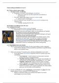
,Map Projections:
Map Projection Information
Cylindrical Map - Straight lines of latitude and longitude meet at
Projection right angles.
- Poles are severely distorted
- Area around the equator is very accurate
- Used to view the world as a whole or
comparing locations (latitude and longitude)
Conic Map - Depicts angular distances between meridians
Projection (longitudes)
- Shows the circular nature of Earth
- Ideal for viewing the Earth by hemisphere
- North distorted (land shrunk) south distorted
(land expanded)
Azimuthal Map - Angular map projection
Projection - Beneficial for finding distance from any point
on Earth
- Significant polar distortions
Robinson Map - Attempt to make the world look right
Projection - Common atlas and wall map projection
- Poles are distorted to make all other land
masses look circular in nature
Transverse - Works well with small areas
Mercator - Typically used with topographic maps,
Projection geological maps, and geological survey maps
- Ineffective when viewing the entire world
, Types of Issues:
4 W Geographic Inquiry Approach
● What is Where? - Location
- Physical features (natural)
- Cultural features (man-made)
● Why There?
- Causes of the issue
- Process responsible for the cause
- Define Interrelationships that are impacted by the cause and the process
● Why Care? - Importance - Relevance - Implication of the Decision
● What to do? - Planning - Decision-making - Action
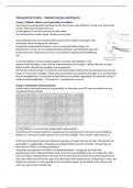
Subduction Zone:
- This process happens when a continental and an oceanic plate are converging.
- The convergence of a continental plate and an oceanic plate will force the denser oceanic
plate to submerge under the continental plate.
- This action is usually smooth and stable, as the bedrock from the oceanic plate will be
driven into the mantle where the rock will melt into magma and be recycled at a
divergent boundary
- The water from the oceanic plate will help lubricate the process
- Subduction zones are home to high-magnitude earthquakes.
Theory of Plate Tectonics:
● 50 years after Wegener’s theory was released and proven, a group of geologists, including
a Canadian (Tuzo Wilson) tried to answer HOW Continental Drift happened
● They theorized that the earth’s continents and oceans sit on numerous plates (7 major, and
many smaller ones) that are constantly moving
● This movement is controlled by convection currents (uneven distribution of heat) that
occur in the mantle (asthenosphere)
● Plate tectonics are responsible for: earthquakes, volcanoes, mountain ranges, ridges, rift
valley formation, fertile plains, etc
Soil Profiles:
True Soil - The three horizons include:
● Top-soil - Horizon A
● Subsoil - Horizon B
● Parent Material - Horizon C
This type of soil profile will have very little vegetation limitation, meaning that this soil can
grow almost any agricultural product
Drawing:
CGC1WA.2
Study Topics for Multiple Choice and True/False
Lines of latitude (temperature) and longitude (time zones):
Latitude - Horizontal lines measuring north or south of the Equator (0°). Range: 0°-90°
- Countries above this line are in the northern hemisphere
- Countries below this line are in the southern hemisphere
Longitude - Vertical lines measuring east or west of the Prime Meridian (0°). Range: 0°-180°
- Countries to the left of this line are in the western hemisphere
- Countries to the right of this line are in the eastern hemisphere
- Lines east and west of the Prime Meridian meet at the International Date Line (180°)
Scales and Scale Conversions:
Large Scale Maps - Maps that have a lot of detail
- Maps that cover a small area of land
- Maps that have scales of 1:50,000 or lower
- Eg. Amusement park maps, outlet mall maps, neighborhood maps, etc
Small Scale Maps - Maps that have less detail
- Maps that cover a larger area of land
- Maps that have scales greater than 1:50,000
- Eg. World Map, Country Map, Zoomed-out Google Maps
A map scale can either be a direct statement, representative fraction, or a linear scale
Direct Statement - Scale stated in words
- States what one centimeter on the map represents in reality
- Eg. 1cm = 100 km
Representative Fraction - Most common scale and can be found on most maps
- The scale is expressed as a ratio … both numbers that are stated are in the same unit of
measure
- Eg. 1:100,000,000 (to convert you have to direct, you have to divide by 100,000)
Linear Scale - shows divisions as to what one centimeter would represent in reality
- Linear scale is a visual representation of a direct statement
- Eg. If the direct statement scale was 1cm = 25km, then the linear scale is:
75km
,Map Projections:
Map Projection Information
Cylindrical Map - Straight lines of latitude and longitude meet at
Projection right angles.
- Poles are severely distorted
- Area around the equator is very accurate
- Used to view the world as a whole or
comparing locations (latitude and longitude)
Conic Map - Depicts angular distances between meridians
Projection (longitudes)
- Shows the circular nature of Earth
- Ideal for viewing the Earth by hemisphere
- North distorted (land shrunk) south distorted
(land expanded)
Azimuthal Map - Angular map projection
Projection - Beneficial for finding distance from any point
on Earth
- Significant polar distortions
Robinson Map - Attempt to make the world look right
Projection - Common atlas and wall map projection
- Poles are distorted to make all other land
masses look circular in nature
Transverse - Works well with small areas
Mercator - Typically used with topographic maps,
Projection geological maps, and geological survey maps
- Ineffective when viewing the entire world
, Types of Issues:
4 W Geographic Inquiry Approach
● What is Where? - Location
- Physical features (natural)
- Cultural features (man-made)
● Why There?
- Causes of the issue
- Process responsible for the cause
- Define Interrelationships that are impacted by the cause and the process
● Why Care? - Importance - Relevance - Implication of the Decision
● What to do? - Planning - Decision-making - Action
Subduction Zone:
- This process happens when a continental and an oceanic plate are converging.
- The convergence of a continental plate and an oceanic plate will force the denser oceanic
plate to submerge under the continental plate.
- This action is usually smooth and stable, as the bedrock from the oceanic plate will be
driven into the mantle where the rock will melt into magma and be recycled at a
divergent boundary
- The water from the oceanic plate will help lubricate the process
- Subduction zones are home to high-magnitude earthquakes.
Theory of Plate Tectonics:
● 50 years after Wegener’s theory was released and proven, a group of geologists, including
a Canadian (Tuzo Wilson) tried to answer HOW Continental Drift happened
● They theorized that the earth’s continents and oceans sit on numerous plates (7 major, and
many smaller ones) that are constantly moving
● This movement is controlled by convection currents (uneven distribution of heat) that
occur in the mantle (asthenosphere)
● Plate tectonics are responsible for: earthquakes, volcanoes, mountain ranges, ridges, rift
valley formation, fertile plains, etc
Soil Profiles:
True Soil - The three horizons include:
● Top-soil - Horizon A
● Subsoil - Horizon B
● Parent Material - Horizon C
This type of soil profile will have very little vegetation limitation, meaning that this soil can
grow almost any agricultural product
Drawing: