Examen
Sketching Assignment - Topographic Maps - Already Graded A+
Note
Vendu
-
Pages
6
Grade
A+
Publié le
14-07-2023
Écrit en
2022/2023
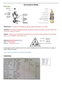
ESC1000L, GLY1010L Lab 2: Topographic Maps Elaborate A: Understanding Elevations and Topographic Contours 1. The map below shows topographic contours at an interval of 20 m. Starting from the 0 m contour at the shoreline, label the elevations of the contours on the map below. Note that the closed contours with the inward hatches are depressions where the elevation decreases towards the center.
Montrer plus
Lire moins
Établissement
Cours
Oups ! Impossible de charger votre document. Réessayez ou contactez le support.
École, étude et sujet
- Établissement
- Florida International University
- Cours
- MAN 3025 Organization & Management
Tous les documents sur ce sujet (3)
Infos sur le Document
- Publié le
- 14 juillet 2023
- Nombre de pages
- 6
- Écrit en
- 2022/2023
- Type
- Examen
- Contient
- Questions et réponses
Sujets
-
sketching assignment topographic maps
€9,42
Accéder à l'intégralité du document:
Garantie de satisfaction à 100%
Disponible immédiatement après paiement
En ligne et en PDF
Tu n'es attaché à rien
Faites connaissance avec le vendeur
Les scores de réputation sont basés sur le nombre de documents qu'un vendeur a vendus contre paiement ainsi que sur les avis qu'il a reçu pour ces documents. Il y a trois niveaux: Bronze, Argent et Or. Plus la réputation est bonne, plus vous pouvez faire confiance sur la qualité du travail des vendeurs.
ExamsConnoisseur