Inhoud
Formules.................................................................................................................................................3
Week 1 (Navigation)...............................................................................................................................4
Altitude...............................................................................................................................................4
Distance..............................................................................................................................................5
Heading Track.....................................................................................................................................5
Internal navigation.............................................................................................................................6
Longitude latitude..............................................................................................................................7
Radio Navigation................................................................................................................................7
Time....................................................................................................................................................8
Wind Triangle.....................................................................................................................................8
Workshop...........................................................................................................................................9
Week 2 (GNSS)......................................................................................................................................10
Satellite Based Navigation................................................................................................................10
Augmented systems.........................................................................................................................12
Workshop.........................................................................................................................................14
Week 3 (Surveillance)...........................................................................................................................15
MLAT: Multilateration systems- Wide Area Multilateration.............................................................15
WAM: Wide Area Multilateration.....................................................................................................17
Electronic conspicuity.......................................................................................................................20
Workshop.........................................................................................................................................20
Week 4 (Communication).....................................................................................................................20
Defitions and SATOM........................................................................................................................20
Radio.............................................................................................................................................22
SATCOM........................................................................................................................................23
Data Systems....................................................................................................................................23
ACARS (Reader)................................................................................................................................25
Workshop.........................................................................................................................................26
SELCAL: Selective Calling...............................................................................................................26
ACARS: Aircraft Communications Addressing and Reporting System...........................................26
CPDLC: Controller-Pilot Data Link Communications.....................................................................26
SWIM: System Wide Information Management...........................................................................27
VoIP: Voice over Internet Protocol...............................................................................................27
GATE LINK:....................................................................................................................................27
Week 5.................................................................................................................................................27
, TCAS: Traffic Collision Avoidance System.........................................................................................27
EGPWS: Enhanced Ground Proximity Warning System....................................................................29
Workshop.........................................................................................................................................30
Week 6 (ATM).......................................................................................................................................30
ANS and Transponder.......................................................................................................................30
ICAO, EASA and SWIM......................................................................................................................32
Workshop:’.......................................................................................................................................35
LVNL..............................................................................................................................................35
ANS...............................................................................................................................................36
Surveillance:.................................................................................................................................37
Week 7 (masterclass LVNL)...................................................................................................................39
Function LVNL...................................................................................................................................39
ADSB/C radar conclusion..............................................................................................................41
GNSS conclusion...........................................................................................................................42
Week 8 (Unmanned Aircraft Systems)..................................................................................................43
Safety and Security...........................................................................................................................45
Workshop.........................................................................................................................................46
,Formules
, Week 1 (Navigation)
Altitude
Transition level: Located at 180.000 ft, where the switch is made from to QNH to flight levels. (For
the US 180.000 ft but can be 3000 ft)
MSL: Mean Sea Level
AGL: Above Ground Level
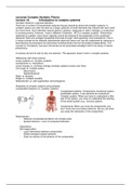
Types of attitude:
- Indicated (altimeter) altitude is the
reading on the altimeter when the
altimeter is set to the local
barometric pressure at Mean Sea
Level.
- Absolute (distance above ground)
altitude is the height of the aircraft
above the terrain over which it is
flying. Also referred to feet/metres
above ground level (AGL).
- True (elevation above sea level) altitude is the actual elevation above mean sea level. It is
Indicated Altitude corrected for non-standard temperature andpressure. In UK aviation
radiotelephony usage, the vertical distance of a level, a point or an object considered as a
point, measured from mean sea level; this is referred to over the radio as altitude.(see QNH)
- Height (distance above certain point) is the elevation above a ground reference point,
commonly the terrain elevation. In UK aviation radiotelephony usage, the vertical distance of
a level, a point or an object considered as a point, measured from a specified datum; this is
referred to over the radio as height, where the specified datum is the airfield elevation (see
QFE).
- Pressure (ISA) altitude is the elevation above a standard datum air-pressure plane (typically,
1013,25 hPaor 29.92" Hg). Pressure altitude and indicated altitude are the same when the
altimeter setting is 29.92" Hg or 1013,25 hPa.
- Density (non ISA) altitude is the altitude corrected for non-ISA International Standard
Atmosphere atmospheric conditions. Aircraft performance depends on density altitude,
which is affected by barometric pressure, humidity and temperature. On a very hot day,
density altitude at an airport (especially one at a high elevation) may be so high as to
preclude take-off, particularly for helicopters or a heavily loaded aircraft
Altimeter settings:
- QNE: Reads FL above MSL when flying above transition altitude. Temperature corrections
required from ISA and airfield pressure deviations for height indication.
- QNH: Reads airfield elevation above MSL when located on the airfield. Temperature must be
corrected for true height.
- QFE: Reads zero when at the reference datum of an airfield. In ISA conditions the meter will
read height above the airfield.
Formules.................................................................................................................................................3
Week 1 (Navigation)...............................................................................................................................4
Altitude...............................................................................................................................................4
Distance..............................................................................................................................................5
Heading Track.....................................................................................................................................5
Internal navigation.............................................................................................................................6
Longitude latitude..............................................................................................................................7
Radio Navigation................................................................................................................................7
Time....................................................................................................................................................8
Wind Triangle.....................................................................................................................................8
Workshop...........................................................................................................................................9
Week 2 (GNSS)......................................................................................................................................10
Satellite Based Navigation................................................................................................................10
Augmented systems.........................................................................................................................12
Workshop.........................................................................................................................................14
Week 3 (Surveillance)...........................................................................................................................15
MLAT: Multilateration systems- Wide Area Multilateration.............................................................15
WAM: Wide Area Multilateration.....................................................................................................17
Electronic conspicuity.......................................................................................................................20
Workshop.........................................................................................................................................20
Week 4 (Communication).....................................................................................................................20
Defitions and SATOM........................................................................................................................20
Radio.............................................................................................................................................22
SATCOM........................................................................................................................................23
Data Systems....................................................................................................................................23
ACARS (Reader)................................................................................................................................25
Workshop.........................................................................................................................................26
SELCAL: Selective Calling...............................................................................................................26
ACARS: Aircraft Communications Addressing and Reporting System...........................................26
CPDLC: Controller-Pilot Data Link Communications.....................................................................26
SWIM: System Wide Information Management...........................................................................27
VoIP: Voice over Internet Protocol...............................................................................................27
GATE LINK:....................................................................................................................................27
Week 5.................................................................................................................................................27
, TCAS: Traffic Collision Avoidance System.........................................................................................27
EGPWS: Enhanced Ground Proximity Warning System....................................................................29
Workshop.........................................................................................................................................30
Week 6 (ATM).......................................................................................................................................30
ANS and Transponder.......................................................................................................................30
ICAO, EASA and SWIM......................................................................................................................32
Workshop:’.......................................................................................................................................35
LVNL..............................................................................................................................................35
ANS...............................................................................................................................................36
Surveillance:.................................................................................................................................37
Week 7 (masterclass LVNL)...................................................................................................................39
Function LVNL...................................................................................................................................39
ADSB/C radar conclusion..............................................................................................................41
GNSS conclusion...........................................................................................................................42
Week 8 (Unmanned Aircraft Systems)..................................................................................................43
Safety and Security...........................................................................................................................45
Workshop.........................................................................................................................................46
,Formules
, Week 1 (Navigation)
Altitude
Transition level: Located at 180.000 ft, where the switch is made from to QNH to flight levels. (For
the US 180.000 ft but can be 3000 ft)
MSL: Mean Sea Level
AGL: Above Ground Level
Types of attitude:
- Indicated (altimeter) altitude is the
reading on the altimeter when the
altimeter is set to the local
barometric pressure at Mean Sea
Level.
- Absolute (distance above ground)
altitude is the height of the aircraft
above the terrain over which it is
flying. Also referred to feet/metres
above ground level (AGL).
- True (elevation above sea level) altitude is the actual elevation above mean sea level. It is
Indicated Altitude corrected for non-standard temperature andpressure. In UK aviation
radiotelephony usage, the vertical distance of a level, a point or an object considered as a
point, measured from mean sea level; this is referred to over the radio as altitude.(see QNH)
- Height (distance above certain point) is the elevation above a ground reference point,
commonly the terrain elevation. In UK aviation radiotelephony usage, the vertical distance of
a level, a point or an object considered as a point, measured from a specified datum; this is
referred to over the radio as height, where the specified datum is the airfield elevation (see
QFE).
- Pressure (ISA) altitude is the elevation above a standard datum air-pressure plane (typically,
1013,25 hPaor 29.92" Hg). Pressure altitude and indicated altitude are the same when the
altimeter setting is 29.92" Hg or 1013,25 hPa.
- Density (non ISA) altitude is the altitude corrected for non-ISA International Standard
Atmosphere atmospheric conditions. Aircraft performance depends on density altitude,
which is affected by barometric pressure, humidity and temperature. On a very hot day,
density altitude at an airport (especially one at a high elevation) may be so high as to
preclude take-off, particularly for helicopters or a heavily loaded aircraft
Altimeter settings:
- QNE: Reads FL above MSL when flying above transition altitude. Temperature corrections
required from ISA and airfield pressure deviations for height indication.
- QNH: Reads airfield elevation above MSL when located on the airfield. Temperature must be
corrected for true height.
- QFE: Reads zero when at the reference datum of an airfield. In ISA conditions the meter will
read height above the airfield.