Topographic maps
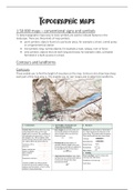
1:50 000 maps – conventional signs and symbols
To keep topographic maps easy to read, symbols are used to indicate features in the
landscape. There are three kinds of map symbols:
• point symbols: objects found at a particular place, for example a school, a wind pump
or a trigonometrical station
• line symbols: long, narrow objects, for example a road, railway, river or fence
• area symbols: objects that are both long and broad, for example a lake, cultivated
farmland or a built-up area in a town.
Contours and landforms
Contours
These enable you to find the height of any place on the map. Contours also show how steep
each part of the map area is. This enables you to ‘see’ slopes and to determine landforms.