Date : 2024/01/18
Map skills
Vertical aerial photographs
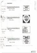
● Aerial photo shows views of the land taken from a camera attached under amd aeroplane .
Oblique aerial photographs show of the land from above at an angle.
● Vertical aerial photographs show the land from directly above Earth’s surface .
● Vertical aerial photographs help cartographers view the Earth’s surface from thee same angle as a
map.
● The scale of the vertical aerial photo is only accurate towards the center of the image .
A contour line is a symbolic horizontal line indicating the height and shape of a slope.
● We use contour lines on maps to give us information about the height an shape of landscape features
such as hills, mountains and valleys .
The concept of contour lines ( models and landscape maps with landscape features )
● Map are not realistic in the same way that photographs are.
We use symbols and colours on maps to represent objects that are on the ground .
● Contour lines are a type of symbol that is used to show height on maps .
Contour lines provide information about the height and shape of objects
Contour lines
● Map makers ( cartographers ) decided if they want to shoe a contour line every 20cm, 50cm, or
100m.
● The distance between each contour is known as the contour interval .
● Cartographsers study vertical aerial photographs , satellite images and land surveys done on the
ground , to find out as much as possible about the area.
Pg 11
, Date : 2024/02/2
Geography
—---------------------------------------------------------------------------------------------------------------------------------
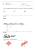
Contour patterns showing river valleys hills , mountains , ridges and spurs
1. Mountains , hills , spurs and river valleys are popular features on topographic maps .
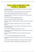
Steep and gentle slopes
● Gradient describes the steepness of a slope Steepness tells us about the angle of the slope .
● A slope will have a steep gradient if there is a big difference in the height between 2 places , while
the horizontal distance between the 2 places is still small . An example of this is a cilff.
● A slope will have a gentle gradient if the height diffrence between the two places is small and the
land distance is long , for example a gently sloping field .
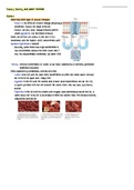
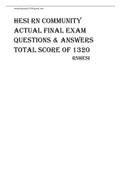
The same hill from a side view and a top view
1. Contour lines that are close together indicate a steep slope while countour lines that are futhuer apart
indicate a gentle slope .
● To calculate gradient we need to know the height between two places and the horizontal distance
between two places . the formula that is used to calculate gradient is as follows :
Gradient = Vertical height difference / Horizontal difference
We describe gradient as a ration .
1/10 as a ratio is 1:10
This mean we need to travel ten meters to go up 1 meter in height .
\
Map skills
Vertical aerial photographs
● Aerial photo shows views of the land taken from a camera attached under amd aeroplane .
Oblique aerial photographs show of the land from above at an angle.
● Vertical aerial photographs show the land from directly above Earth’s surface .
● Vertical aerial photographs help cartographers view the Earth’s surface from thee same angle as a
map.
● The scale of the vertical aerial photo is only accurate towards the center of the image .
A contour line is a symbolic horizontal line indicating the height and shape of a slope.
● We use contour lines on maps to give us information about the height an shape of landscape features
such as hills, mountains and valleys .
The concept of contour lines ( models and landscape maps with landscape features )
● Map are not realistic in the same way that photographs are.
We use symbols and colours on maps to represent objects that are on the ground .
● Contour lines are a type of symbol that is used to show height on maps .
Contour lines provide information about the height and shape of objects
Contour lines
● Map makers ( cartographers ) decided if they want to shoe a contour line every 20cm, 50cm, or
100m.
● The distance between each contour is known as the contour interval .
● Cartographsers study vertical aerial photographs , satellite images and land surveys done on the
ground , to find out as much as possible about the area.
Pg 11
, Date : 2024/02/2
Geography
—---------------------------------------------------------------------------------------------------------------------------------
Contour patterns showing river valleys hills , mountains , ridges and spurs
1. Mountains , hills , spurs and river valleys are popular features on topographic maps .
Steep and gentle slopes
● Gradient describes the steepness of a slope Steepness tells us about the angle of the slope .
● A slope will have a steep gradient if there is a big difference in the height between 2 places , while
the horizontal distance between the 2 places is still small . An example of this is a cilff.
● A slope will have a gentle gradient if the height diffrence between the two places is small and the
land distance is long , for example a gently sloping field .
The same hill from a side view and a top view
1. Contour lines that are close together indicate a steep slope while countour lines that are futhuer apart
indicate a gentle slope .
● To calculate gradient we need to know the height between two places and the horizontal distance
between two places . the formula that is used to calculate gradient is as follows :
Gradient = Vertical height difference / Horizontal difference
We describe gradient as a ration .
1/10 as a ratio is 1:10
This mean we need to travel ten meters to go up 1 meter in height .
\