SOCIAL SCIENCES
, CONTOUR LINES [MAPWORK]
CONTOUR LINES → (contour) lines on a map > connect places of the same height above sea
level [indicate landscape phenomena]
→ symbolic horizontal line indicating height and the shape of the slopesi
→ accurate way to indicate relief on maps [shape, size & steepness]
[relief > shape of the earth's surface > unevenness of the surface]
NOTES:
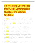
Z Numbers / figures on the
contour lines > HEIGHT (in
Steep slope Gradual slope meters above sea level)
Z Contour interval > distance
between each contour line
(e.g. 20m)
DIFFERENCE BETWEEN A HILL
AND A RIDGE:
Height (m) ridge > long, narrow & steep
hilltop / mountain range
HILL
RIDGE
STEEP & GRADUAL SLOPES:
[Slope = Gradient]
Gradient > describes how style is a slope [determined by the angle of the slope]
GRADE 9 > TERM 1
STEEP GRADIENT IN SLOPE → if there is a large difference in height between locations,
while the horizontal distance between the two locations is small (e.g. cliff) [contour lines
that are CLOSE to each other]
EVEN / GRADUAL GRADIENT IN SLOPE → if there is a small difference in elevation between
locations, while the horizontal distance between the two locations is far [contour lines
that are FAR apart]
gradient=
*** a small dot ( ⚫ ) > highest point difference in vertical height [m]
horizontal distance [m]
2 © Noted Summaries Grade 9 SS Part 1 : Geography www.notedsummaries.co.za
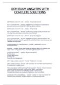
, RIVER VALLEYS & SPURS:
VALLEY → low-lying land between hills and mountains where rivers flow thickly > ( V
shaped and runs upwards )
SPUR → finger-like pieces of land that run down from a mountain or hill > ( U shaped and
run downwards ) > stone ridges that form the valley
3 © Noted Summaries Grade 9 SS Part 1 : Geography www.notedsummaries.co.za
, CONTOUR LINES [MAPWORK]
CONTOUR LINES → (contour) lines on a map > connect places of the same height above sea
level [indicate landscape phenomena]
→ symbolic horizontal line indicating height and the shape of the slopesi
→ accurate way to indicate relief on maps [shape, size & steepness]
[relief > shape of the earth's surface > unevenness of the surface]
NOTES:
Z Numbers / figures on the
contour lines > HEIGHT (in
Steep slope Gradual slope meters above sea level)
Z Contour interval > distance
between each contour line
(e.g. 20m)
DIFFERENCE BETWEEN A HILL
AND A RIDGE:
Height (m) ridge > long, narrow & steep
hilltop / mountain range
HILL
RIDGE
STEEP & GRADUAL SLOPES:
[Slope = Gradient]
Gradient > describes how style is a slope [determined by the angle of the slope]
GRADE 9 > TERM 1
STEEP GRADIENT IN SLOPE → if there is a large difference in height between locations,
while the horizontal distance between the two locations is small (e.g. cliff) [contour lines
that are CLOSE to each other]
EVEN / GRADUAL GRADIENT IN SLOPE → if there is a small difference in elevation between
locations, while the horizontal distance between the two locations is far [contour lines
that are FAR apart]
gradient=
*** a small dot ( ⚫ ) > highest point difference in vertical height [m]
horizontal distance [m]
2 © Noted Summaries Grade 9 SS Part 1 : Geography www.notedsummaries.co.za
, RIVER VALLEYS & SPURS:
VALLEY → low-lying land between hills and mountains where rivers flow thickly > ( V
shaped and runs upwards )
SPUR → finger-like pieces of land that run down from a mountain or hill > ( U shaped and
run downwards ) > stone ridges that form the valley
3 © Noted Summaries Grade 9 SS Part 1 : Geography www.notedsummaries.co.za